Your Mobile Support

  • Subscribe to our RSS feed.
  • Twitter
  • StumbleUpon
  • Reddit
  • Facebook
  • Digg

Tuesday, 6 March 2012

Protecting the world’s coral reefs through mapping

Posted on 14:00 by Unknown

Editors Note: Today’s guest author is Katie Reytar, a Research Associate for the World Resources Institute. WRI was the recipient of a Google Earth Outreach Developer Grant, funded through the Google Inc. Charitable Giving Fund at the Tides Foundation. We’re excited to help them share and visualize the results of years of research about the state of the world’s reefs.

Since 1998, the World Resources Institute (WRI) has been using GIS (Geographic Information System) models to develop map-based assessments of threats to the world’s coral reefs. Reefs at Risk Revisited, released in February 2011, is the latest assessment in the series and is based on a nearly three-year study that produced the most highly-detailed global maps of coral reef threats to date. The study analyzed and mapped threats to coral reefs from local human activities such as coastal development, unsustainable fishing, and marine and land-based pollution, as well as climate-related threats caused by increasing levels of greenhouse gases in the atmosphere.

While the Reefs at Risk Revisited report, maps and data sets are the core components of our work, we found ourselves still searching for a compelling way to convey our findings on these dynamic yet fragile reef ecosystems. We also wanted to generate greater awareness of the unique characteristics of reef habitats across different geographies and the irreplaceable cultural and life-sustaining services that reefs provide to people all over the world. All of these elements are best communicated when you can see them for yourself, which is why we created a virtual tour of these reefs around the world with our Google Earth Outreach Developer Grant.

Watch a virtual tour of the most at-risk reefs in the world courtesy of the World Resources Institute.

In the tour, the Reefs at Risk Revisited maps come alive on Google Earth with photos and underwater video from each of the major coral reef regions of the world: the Caribbean, Middle East, Indian Ocean, Southeast Asia, Australia, and Pacific, as well as a global-level introduction and conclusion. The journey to each region provides a brief overview of the biodiversity of reef ecosystems, their importance to people and local economies, and the types and magnitudes of threats that reefs face, illustrated with footage of both healthy and damaged reefs.

You’ll also experience first hand these fantastically dynamic and productive ecosystems that extend across about 250,000 sq km (96,500 sq miles) of the tropical ocean. Even though this area represents less than 0.1% of the global ocean, reefs are home to as many as 25% of all known marine species. In the tropics, coral reefs are not only a critical habitat for marine species, but they also play an essential role in the lives of millions of people who live near them: they provide food and income from fisheries, revenue from tourism, and protection for coastal communities from storm surges.

Among the other products of the Reefs at Risk Revisited project are global maps of coral reefs rated according to level of threat in the present, 2030, and 2050. These maps are available as downloadable KML files on the WRI website for viewing on Google Earth, and also as part of an online map developed using Google Fusion Tables. With these interactive maps you can zoom in to your favorite reef to explore it more closely in your own self-guided tour.

Explore Reefs at Risk Revisited in Google Earth.

We hope that you enjoy our tour and maps, and that you are able to visit a coral reef to learn more about these important and unique ecosystems. With improved understanding, we can manage and protect these resources so that we can all enjoy them and benefit from them for generations to come.

Posted by Katie Reytar, Research Associate at the World Resources Institute
Read More
Posted in Google Earth, Outreach | No comments

Mapping the March to Tampa

Posted on 07:49 by Unknown

Cross-posted on the Google Politics & Elections blog

Super Tuesday has arrived! So far, 12 states have held caucuses or primaries to nominate a Republican presidential candidate in time for the RNC convention in Tampa this August. Today, 10 more states with 419 delegates at stake will get a chance to add their voices. From Alaska’s Bering Sea to the Georgia’s Golden Isles, voting will span five time zones and over 4,000 miles; by the time polling closes in Nome, AK, it’ll be 12 a.m. on the East Coast.

Our Politics & Elections team has mapped the results of every contest since Iowa, and now we’ve upgraded the visualization. The new map lets you track both the state-by-state numbers as well as the results by county, with delegate counts in addition to raw numbers and percentages from the AP. This auto-updating map will live on google.com/elections, and outlets subscribing to Associated Press election results can also embed it on their site.


We also have some other great tools to help you make sense of this year’s political scene. Our infographic gallery features Google Insights for Search data, much of which is broken down by state to make sense of regional variation. Follow the Google+ page for Hangouts on Air with prominent political reporters and daily insight. And if you just want to quickly look up how things are going, you’ll find fresh results in Google search on both desktop and mobile.


Posted by Jesse Friedman, Google Politics & Elections Team
Read More
Posted in Google Maps | No comments

Friday, 24 February 2012

Follow in Darwin's footsteps with the iNaturalist mobile app

Posted on 07:45 by Unknown

Editor’s Note: Today’s guest author is Dr. Scott Loarie, a fellow at the Carnegie Institution for Science at Stanford and co-director of iNaturalist.org, a biodiversity citizen-science website. Pepperwood Preserve was the recipient of a Google Earth Outreach Developer Grant, funded through the Google Inc. Charitable Giving Fund at the Tides Foundation. We’re excited to share how the iNaturalist Android application developed as a result of this grant is being used in action at Pepperwood Preserve.

Last weekend, as I rolled back a piece of bark at Pepperwood Preserve to reveal a big black beetle, I was reminded of a great story about Charles Darwin. Out collecting beetles, Darwin already had a beetle in each hand when he spotted a third. To free up a hand, he popped one of the beetles in his mouth. No sooner had he done this when it excreted some sort of burning liquid onto his tongue forcing him to spit it out, drop the second, and miss his chance for the third.

Now in 2012, all I had to do was point my phone at the beetle and snap its picture with the iNaturalist app (available on iOS and Android). Beetle mishaps aside, following in Darwin's footsteps wasn't really something non-scientists could participate in until recently. Specimens had to be collected, stuffed and shipped to museums where they were identified, labeled and catalogued. But with new technologies like Google Maps and smartphones, contributing data to museums now only takes a single click.

Pepperwood Research Specialist Morgan Kennedy demonstrates how to use the iNaturalist app to observe a native grass at Pepperwood Preserve.

Last Saturday, Morgan Kennedy introduced the Pepperwood Vital Signs project on iNaturalist.org, a citizen-science website I help direct, to a group of about 20 community members at Pepperwood Preserve. The project aims to map the distribution of plants and animals across the preserve with geo-referenced photos contributed by community members. The community members participating in the project often don't know the name of the species they are photographing, but by passing the contributions on to international museum consortiums and conservation organizations, iNaturalist photos are usually identified by scientists and experts within a few days.

Over the last year, community members have documented more than 400 distinct species by uploading more than 900 geo-referenced photos from Pepperwood. As the pilot preserve participating in the new Bay Area Open Space Council BioAtlas initiative, Pepperwood is developing ways to use iNaturalist to assemble the contributed data into digital education materials that can be used by the preserves to further engage and educate their community members.

This Google Map shows the Pepperwood Boundaries and more than 900 contributions to the Pepperwood Vital Signs project on iNaturalist.org.

Saturday's training was especially exciting because Morgan demoed the new Android App that iNaturalist developed with the support of a Google Earth Outreach Developer Grant to Pepperwood. By making the contribution of data to museums easy and fun, the Android app clears a major barrier towards recruiting non-scientists to participate.

These reinforcements couldn't have arrived sooner. Plants and animals are disappearing about 1,000 times faster than normal with ongoing climate and land-use change, and one of the most difficult hurdles towards addressing these challenges has been the basic scarcity of information about where plants and animals persist and where they do not. Without the help of non-scientists, the handfuls of museums and graduate students tasked with providing this information simply can't scale to meet these challenges.

Want to get involved? Download the app (on iOS or Android), get outdoors, and start documenting nature from wherever you are in the world! If you want to start your own regional project, like the Pepperwood Vital Signs project, you can do that here. You'll be following in Darwin's footsteps - just don't be tempted to put any beetles in your mouth!

Posted by Scott Loarie, co-director iNaturalist.org
Read More
Posted in Google Earth, Outreach | No comments

Thursday, 23 February 2012

Imagery Update: Week of February 20th

Posted on 13:00 by Unknown

The Google Earth and Maps Imagery team recently published another batch of satellite imagery. In this post, we’ll explore a few well-known locations from across the globe.

Our first example is the Bristol Motor Speedway, located outside of Bristol, Tennessee. This NASCAR short track speedway is the 8th largest sports venue in the world, and hosts up to 165,000 people.

Bristol Motor Speedway, Bristol, Tennessee

If you think the typical NASCAR race is too crowded, how about visiting a location with a few million others on a single day? That’s the estimated crowd size expected each year to the Kaba (shown below), in Mecca, Saudi Arabia, on the day of the annual Islamic pilgrimage Hajj.

The Kaaba, Mecca, Saudi Arabia

Another great place to visit - either virtually or in person - is the Grand Mediation Amphitheatre located in the World Dhammakaya Centre in Pathum Thani Province, Thailand. As shown below, the Centre provides a place where anyone is welcome to meditate.

The World Dhammakaya Centre, Pathum Thani Province, Thailand

If you prefer to spend your leisure time contemplating classic literature, you’ll enjoy this final example from Spain’s central La Mancha region. This perspective view highlights the vineyards and arid plateaus that form the backdrop of The Ingenious Gentleman Don Quixote of La Mancha.

Perspective view of Castile–La Mancha, Spain

If you’d like to receive an email notification when the Google Earth and Maps Imagery team updates your favorite areas(s), we’ve got just the tool: The Follow Your World application!

These are only a few examples of the sites that can be seen and discovered in our latest batch of published imagery. Happy exploring!

Countries/regions receiving high resolution satellite updates:
Albania, Algeria, Angola, Antarctica, Argentina, Armenia, Australia, Austria, Azerbaijan, Bangladesh, Belarus, Belize, Benin, Bermuda, Bolivia, Bosnia and Herzegovina, Botswana, Brazil, Bulgaria, Burkina Faso, Burundi, Cambodia, Cameroon, Canada, Cape Verde, Central African Republic, Chad, Chile, China, Colombia, Costa Rica, Croatia, Cuba, Cyprus, Czech Republic, Democratic Republic of the Congo, Djibouti, Dominican Republic, Ecuador, Egypt, El Salvador, Eritrea, Estonia, Ethiopia, Fiji, Finland, France, Gabon, Georgia, Germany, Ghana, Gibraltar, Greece, Greenland, Grenada, Guatemala, Guinea, Guinea-Bissau, Haiti, Honduras, Hungary, India, Indonesia, Iran, Ireland, Israel, Italy, Japan, Jordan, Kazakhstan, Kenya, Kuwait, Kyrgyzstan, Laos, Lebanon, Lesotho, Liberia, Libya, Lithuania, Macedonia, Madagascar, Malawi, Mali, Marshall Islands, Mauritania, Mayotte, Mexico, Moldova, Mongolia, Morocco, Mozambique, Myanmar, Namibia, Nepal, Netherlands, New Zealand, Nicaragua, Niger, Nigeria, North Korea, Norway, Oman, Pakistan, Panama, Papua New Guinea, Paraguay, People's Republic of the Congo, Peru, Philippines, Poland, Portugal, Qatar, Romania, Russia, Rwanda, Saudi Arabia, Senegal, Serbia, Slovakia, Slovenia, Somalia, South Africa, South Korea, Spain, Sri Lanka, Sudan, Suriname, Svalbard, Swaziland, Sweden, Switzerland, Syria, Taiwan, Tajikistan, Tanzania, Thailand, The Bahamas, The Gambia, Timor-Leste, Tunisia, Turkey, Turkmenistan, Uganda, Ukraine, United Arab Emirates, United Kingdom, United States, Uruguay, Uzbekistan, Venezuela, Vietnam, Western Sahara, Yemen, Zambia, Zimbabwe.

These updates are now available in both Google Maps and Google Earth. For a complete picture of where we updated imagery, download this KML for viewing in Google Earth.

Posted by Eric Kolb, Geo Data Strategist
Read More
Posted in Google Earth, Google Maps, imagery | No comments

Wednesday, 22 February 2012

Enhanced search in Google Earth 6.2

Posted on 07:00 by Unknown

Lao-tzu once said, “The journey of a thousand miles begins with a single step.” In Google Earth, that single step is often searching for the name of the place you want to go. The search field is the gateway to all of the amazing places you might visit, and for the recent release of Google Earth 6.2, we worked hard to make it even more powerful and easy to use.

As a result, searching for a location in Google Earth 6.2 is a bit different: we’ve streamlined the look and feel of the search interface, removing tabs and consolidating all the search fields together into one (just like Google Search). We’ve also added features that Google Earth previously didn’t have, like transit directions and search layers. And we’ve made sure that underneath these shiny new features, you still have access to the power and flexibility of KML.

If you live in one of the many metropolitan areas supported by Google Transit, you’ve probably used the transit directions search on Google Maps to plan a trip. Now you can do the same thing in 3D with Google Earth. Select “Get Directions” and enter your endpoints, then choose the train icon at the top of the search results for public route instructions. You can also click on any of the transit stations or stops to fly there. Be sure to turn on 3D buildings - some train stations are really quite pretty! You’ll also notice icons for walking and biking directions, so if you’ve ever wanted to go on a virtual tour of your next cycling excursion, or find out just how steep that hill is before you commit to the journey, now you can.

New transit directions in Google Earth 6.2

Search layers were first introduced in Google Maps a few years ago, and at last, they’ve recently made their way to Google Earth. Search layers enable you to see all the results of your search on the map at once, not just the top ten, making it easy to find clusters of certain types of businesses like fast food restaurants or coffee shops. One of the more entertaining uses of search layers that I’ve found has to do with a road that will be familiar to anyone who’s visited California: El Camino Real. Stretching from Sonoma Valley to San Diego, El Camino is a great place to find shops and restaurants of all kinds - and lots of them! Here’s a search layer for all the pizza places in the San Francisco Bay area; can you spot El Camino?

Search in Google Earth is much more than a pretty face, though. Just beneath the surface lies the powerful KML language, which you can use to take full control of your searches. Right-click on any search listing to save it to My Places or copy it as KML text, or click one of the icons below the search results to save or copy everything all at once. Save your walking directions to My Places and start a tour of the route to get turn-by-turn directions from the comfort of your chair. You can also click on “History” below the search field to see all of your recent searches at once, and selectively hide and show results to get, say, a picture of the top ten hotels and crêpe restaurants in Paris, for optimal crêpe-eating efficiency.

We’ll continue to improve the search experience in Google Earth, so stay tuned, and keep those searches coming!

Posted by Brian Ellis, Software Engineer, Google Earth
Read More
Posted in Google Earth, Transit | No comments

Tuesday, 21 February 2012

Street View on Google Maps comes to Russia

Posted on 15:22 by Unknown

Welcome to Russia! You can now virtually travel through the world’s largest country to the cities of Moscow and St. Petersburg using Google Maps Street View.

Take an online stroll around famous Red Square and Moscow Kremlin, or go to outskirts of Moscow to wander around the beautiful Tsaritsino or Kuskovo parks. You can also visit the former site of the palace in Kolomenskoye, once considered the 8th World Wonder.

View Larger Map

Red Square, Moscow

St. Petersburg, the second largest city in Russia and northernmost megapolis in the world, was once a country capital, and the history of this young city started with The Peter and Paul Fortress. Today, the entire historical center of St. Petersburg is a UNESCO Heritage Site that you can enjoy via Street View.

View Larger Map

Historical Center, St. Petersburg

Within St. Petersburg, you can see the great palaces and parks that Russian emperors and nobles built, with Peterhof being its crown jewel. In fact, whole southern shore on the Gulf of Finland consists of palaces and parks including Peterhof, the Oranienbaum, and Alexandria.


View Larger Map

Peterhof, St. Petersburg

We hope you enjoy your virtual trip to Russia, and look forward to sharing more countries, cultures and sites as Street View continues to expand to more places. For a demo on how Street View works, start here.

Also, if you have a story to share about a place in Russia, find it in Street View and share it on Google+ with the #streetview.

Posted by Boris Khvostichenko, Product Manager, Google Russia
Read More
Posted in imagery, Russia, Street View | No comments

Wednesday, 15 February 2012

Lay claim to your personal conservation plot with Adopt-an-Acre

Posted on 12:00 by Unknown

One of my favorite quotes is by American anthropologist Margaret Mead: “Never doubt that a small group of thoughtful, committed citizens can change the world. Indeed, it is the only thing that ever has.”

We can each play an active role in changing the world for the better by preserving areas we care about. The Nature Conservancy has just made it easier with their Adopt-an-Acre program. They’ve updated their mapping tool today as the result of a Google Earth Outreach Developer Grant, which offers funding to organizations that create clever, cutting-edge applications using Google mapping technologies.

One of the solutions for widespread habitat loss is to acquire large plots of land for conservation. Since 1991, the Adopt-an-Acre program has protected more than 600,000 acres spanning from North America to Africa and Australia, even protecting offshore areas critical for delicate coral reefs and humpback breeding grounds.

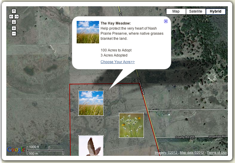
Adopt an acre through the Nature Conservancy

There are two featured areas that allow you to adopt a specific acre, the Nash Prairie Preserve in Texas and the Warm Springs Mountain Preserve in Virginia. Simply fly to ground level on the embedded Google Map and choose your acre. You can also select your plot through Google Earth by clicking on the “View in Google Earth” link. This map enables any interested individual to make a pledge and help restore an acre of land to its pristine state.

The Nash Prairie Preserve in Texas is a beautiful and vital tall prairie grassland. These prairies used to cover wide expanses in the Bottomlands region of coastal Texas, but these areas have been reduced due to metropolitan encroachment. More than 120 bird species and 300 plant species thrive in this disappearing ecosystem, which you can help protect.

The Warm Springs Mountain Preserve in Virginia is the other area within a 77,000 acre wildlife corridor where you can adopt a specific acre. If you have a connection to the Allegheny Mountains in Virginia, or if you are passionate about preserving species like the interior dwelling songbird, you can choose from a variety of landscapes, pristine rivers and mountain forests to conserve.

Best of all, you can adopt an acre in the name of a loved one or as a gift to someone else. Their name will appear on the map alongside others who have entered their names in support of preserving our wild America.

Learn more about what nonprofits have done with mapping technologies on the Google Earth Outreach website.

Posted by Tanya Birch, Google Earth Outreach
Read More
Posted in Google Earth, Google Maps, Outreach | No comments
Newer Posts Older Posts Home
Subscribe to: Posts (Atom)

Popular Posts

  • Help improve the “blue dot” for people visiting your venue
    When we announced the availability of indoor maps for Android last November , we also introduced Google Maps Floor Plans as a tool for busi...
  • Take off for the holidays with Google Street View
    Whether it’s touring the canals of Venice , swimming with the seals in the Galapagos or climbing the Burj Khalifa in Dubai, Street View ha...
  • Imagery Update - Week of May 16th
    The Google Earth and Google Maps Imagery Team has just published its latest batch of satellite and aerial imagery, and as always, there ar...
  • Imagery Update - Week of May 31st
    The Google Earth and Google Maps Imagery Team has just published its first batch of satellite and aerial imagery for June, and as always, ...
  • Welcome to the world’s largest intact forest: Canada’s boreal
    Editor’s Note: Today's guest author is Steve Kallick, from the Pew Environment Group’s International Boreal Conservation Campaign. We ar...
  • Why maps matter: Using digital cartography tools to change the world
    People have created maps since early civilization, but only recently have digital mapping tools like Google Earth and Maps made it easy to...
  • Imagery Update: Week of August 29th
    The Google Earth and Google Maps Imagery Team has published their latest batch of aerial and satellite imagery! In this blog post, we’d li...
  • Take a trip to the Super Bowl with Google Earth
    We’re two days away from one of my favorite events of the year, the Super Bowl (and I’m sure I’m not alone!). I’m one of those fans who star...
  • Traffic and Transit Come to Google Maps in Malaysia
    We originally launched Google Maps in Malaysia back in 2009, and since then, Malaysians have been avid users of the service on both their d...
  • Google Maps Roundup for September: Making Google Maps even better for you
    As always, we’re focused on making Google Maps the best it can be for people around the world. In September, we added many new features to G...

Categories

  • #treasuremap
  • +1
  • 3D
  • 8bitmaps
  • Adwords Express
  • Africa
  • Amazon
  • Andorra
  • Android
  • api
  • Art Project
  • Audi
  • biking
  • Boost
  • Boulder
  • Brazil
  • Bulgaria
  • Business Photos
  • Canada
  • check-in
  • community
  • competition
  • contest
  • crisis response
  • Culture
  • custom maps
  • developer
  • Developers
  • directions
  • disaster response
  • discovery
  • Download Free Nokia 6680 PC Suite
  • Download Micromax pc suite
  • Download Micromax pc suite for window
  • Download micromax Q5 Pc suite
  • Download PC suite
  • Download Samsung Mobile Pc Suite
  • earth outreach
  • education
  • Enterprise
  • Estonia
  • Europe
  • Fusion Tables
  • galaxy s2
  • Gibraltar
  • GMM
  • google
  • Google Earth
  • Google Earth Engine
  • Google Map Maker
  • Google Maps
  • Google Maps API
  • Google Maps Engine
  • Google Maps for Mobile
  • Google Maps Navigation
  • Google Maps Transit
  • Google Places
  • Google Plus
  • Google Search
  • Google Street View
  • google.org
  • Google+
  • googlenew
  • Grand Canyon
  • ground truth
  • Halloween
  • historical
  • history
  • Hotpot
  • HTC PC Suite Download
  • HTC PC suite for WIN 7
  • HTC PC Suite Free Download
  • HTC sync Downlaod
  • HTC Sync Download for windows
  • HTC Sync Free Download
  • Hungary
  • imager
  • imagery
  • Indoor Maps
  • iPhone
  • Iraq
  • Japan
  • Latitude
  • Latvia
  • layers
  • LG Mobile PC Suite
  • LG Mobile Support Tool
  • LG PC suite Download
  • Lithuania
  • London
  • Malaysia
  • Mall of America
  • Map Maker
  • mapsgl
  • Matt Harding
  • Mexico
  • Micromax A110
  • Micromax Canvas 2
  • Micromax pc suite download
  • Micromax PC suite for windows
  • Micromax Q5 FB PC Suite Free Download
  • Micromax Q5 FB PC Suite Free Download For Windows
  • Mircromax Q3 PC Suite Download for windows
  • Mobile
  • Monticello
  • My Maps
  • my places
  • my tracks
  • navigation
  • new Google Maps
  • Nokia 5250 PC Suite Free Download
  • Nokia 5530 PC Suite Free Download
  • Nokia 5610 PC Suite Free Download
  • Nokia 5800 PC Suite Free Download
  • Nokia 6030 PC Suite Free Download
  • Nokia 6680 PC Suite Download for windows
  • Nokia 6680 PC suite free Download
  • Nokia Asha 305
  • Nokia Asha 306 PC Suite download
  • Nokia C3-01
  • Nokia Free Suite
  • Nokia Mobile PC suite Download
  • oblique imagery
  • ocean
  • offline maps
  • Outreach
  • Pakistan
  • Panoramio
  • Parks Canada
  • Pegman
  • photo tours
  • photos
  • picasa
  • Quiz
  • real estate
  • Russia
  • Samsung C3322 PC Suite Free Download
  • Samsung C6712 PC Suite Free Download
  • Samsung Corby 2 PC Suite Free Download
  • Samsung Galaxy
  • Samsung Galaxy 5830 PC Suite Download
  • Samsung Galaxy Ace Hugo Boss
  • Samsung Galaxy Ace PC Suite Download
  • Samsung galaxy I8190 S III PC Suite Download
  • samsung galaxy mega
  • Samsung Galaxy Mega 5.8
  • Samsung Galaxy Mega 6.3
  • samsung galaxy s2
  • Samsung Galaxy Stratosphere II I415
  • samsung GT-I9100 pc suite
  • Samsung GT-S6102 Galaxy Y Duos PC Suite Download
  • Samsung GT-S6102 PC Suite Download
  • Samsung I9000 Galaxy S PC Suite Download
  • Samsung mobile pc suite downlaod
  • samsung mobile pc suite download for Windows 7 ad XP
  • samsung mobile pc suite download for Windows 7 and XP
  • Samsung N7100
  • Samsung Note 2
  • Samsung Note II
  • Samsung PC Suite Download.
  • Samsung Wave Y Drivers Download
  • Samsung Wave Y PC Suite Free Download
  • Santa
  • Santa Tracker
  • search stories
  • SketchUp
  • Slovakia
  • Slovenia
  • Sony PC Companion Free Download
  • Sony PC Suite Free Download
  • South Sudan
  • space
  • Spain
  • sports
  • Street View
  • Sumsang C3322 Drivers Download
  • SXSW
  • Tags
  • Thomas Jefferson
  • Thomas Jefferson Foundation
  • Tip of the week
  • tour guide
  • traffic
  • Train
  • Transit
  • trees
  • Trekker
  • U.S. National Park Service
  • Ukraine
  • University of Virginia
  • voice search
  • walking
  • Waze
  • weather
  • webgl
  • Xperia PC Suite Download
  • zagat

Blog Archive

  • ▼  2013 (87)
    • ▼  November (7)
      • Take off for the holidays with Google Street View
      • Take a hike with Street View through U.S. National...
      • Street View floats into Venice
      • Mapping the world’s deforestation over time
      • Meet nonprofits using “Geo for Good”
      • Tour Builder: Tell your stories with Google Earth
      • From where you are to where you want to go
    • ►  October (3)
    • ►  September (4)
    • ►  August (9)
    • ►  July (13)
    • ►  June (12)
    • ►  May (10)
    • ►  April (9)
    • ►  March (11)
    • ►  February (2)
    • ►  January (7)
  • ►  2012 (192)
    • ►  December (9)
    • ►  November (5)
    • ►  October (24)
    • ►  September (13)
    • ►  August (15)
    • ►  July (18)
    • ►  June (21)
    • ►  May (17)
    • ►  April (19)
    • ►  March (26)
    • ►  February (12)
    • ►  January (13)
  • ►  2011 (234)
    • ►  December (13)
    • ►  November (17)
    • ►  October (19)
    • ►  September (15)
    • ►  August (23)
    • ►  July (25)
    • ►  June (20)
    • ►  May (20)
    • ►  April (23)
    • ►  March (24)
    • ►  February (18)
    • ►  January (17)
  • ►  2010 (21)
    • ►  December (21)
Powered by Blogger.

About Me

Unknown
View my complete profile