Your Mobile Support

  • Subscribe to our RSS feed.
  • Twitter
  • StumbleUpon
  • Reddit
  • Facebook
  • Digg
Showing posts with label Google Earth Engine. Show all posts

Thursday, 14 November 2013

Mapping the world’s deforestation over time

Posted on 11:08 by Unknown

We’re excited to announce today that, in a collaboration led by Dr. Matthew Hansen at the University of Maryland, we’ve built the first detailed maps of the world’s forests, from 2000-2012, documenting and quantifying forest landscape changes such as fires, tornadoes, disease and logging.

The most significant findings were that the overall rate of tropical deforestation is increasing, and global forests have experienced a net loss of 1.5M sq km during 2000-2012 due to both natural (disturbance) and human causes. That’s a loss of forested land comparable in size to the entire state of Alaska.

Global Forest Change, 2000-2012: individual maps of forest extent, gain, loss, and loss color-coded by year. Click to enlarge.

Sumatra has lost over 50% of its natural forest within the past 30 years. Click to enlarge.

The detailed study was published today in the journal Science, High-Resolution Global Maps of 21st-Century Forest Cover Change. Key to the study’s success was the collaboration between scientists at the University of Maryland, who developed the models to analyze Landsat satellite data, and computer scientists at Google, who then used Google Earth Engine technology to run these models on more than 650,000 Landsat images. While the analysis would have taken a single computer more than 15 years to perform, it was completed in a matter of days using Google Earth Engine.

Here are some other notable sites:


Paraguay’s Chaco woodlands within the western half of the country are experiencing rapid deforestation in the development of cattle ranches. The result is the highest rate of deforestation in the world. Click to enlarge.

The Siberian larch forests of Yakutia, Russia, are prone to fire during spring to early summer. Most of these fires are deliberately set and spread uncontrolled. Such extensive fires result in significant carbon emissions. Click to enlarge.


If you'd like to dive even deeper and learn more about this project, head on over to the Google Research blog post authored by Dr. Matt Hansen. Also, tune in next Monday, November 18 at 1:00pm ET, 10:00am PT to an online presentation and demonstration by Matt Hansen and colleagues from UMD, Google, USGS, NASA and the Moore Foundation. Please submit your questions for live Q&A.

Updated 3:30pm PDT: Corrected total sq km of net loss during 2000-2012.

Posted by Rebecca Moore and Matt Hancher, Google Earth Engine team
Read More
Posted in Google Earth Engine | No comments

Wednesday, 26 June 2013

Only clear skies on Google Maps and Earth

Posted on 09:00 by Unknown

To celebrate the sunny days of summer (in the northern hemisphere at least), we're unveiling new satellite imagery for all Google mapping products today. This stunning new imagery of the earth from space virtually eliminates clouds, includes refreshed imagery for regions of the world where high-resolution imagery is not yet available, and offers a more comprehensive and accurate view of the texture of our planet's landscape.
The new, even more beautiful global view in Maps and Earth.

In 2002 NASA released the Blue Marble, a global image of the earth with a resolution of one kilometer per pixel, based on data from NASA’s MODIS instrument. Updated in 2005 to twice the resolution, it has remained the canonical globally-uniform picture of the earth for over a decade.

With the Blue Marble as inspiration, we used Google Earth Engine technology to mine hundreds of terabytes of data from the USGS’s and NASA’s Landsat 7 satellite. The result is a seamless, globally-consistent image of the entire planet with a resolution of 15 meters per pixel, far finer than is possible with MODIS data alone.

To get a feel for the difference, here’s a comparison of the Grand Canyon, first from the Blue Marble Next Generation (courtesy NASA’s Earth Observatory), and then in our new Landsat-based imagery.
The Grand Canyon, as seen by MODIS and by Landsat 7.

The Landsat 7 satellite suffered a hardware failure early in its life that introduced striped artifacts into all of its images. By analyzing a large number of images we were able to virtually eliminate these stripes, as well as clouds and other atmospheric effects. The process was very similar to how we produced the global time-lapse imagery of the earth that we released last month.

Castellón, Spain: One example Landsat 7 image, and the final combined image.

The resulting 800,000 megapixel global image is so big that if you wanted to print it at a standard resolution of 300 dots per inch you would need a piece of paper the size of a city block!
Northwestern South America: before and after.

Mining data from a large number of Landsat images of each area allowed us to reconstruct cloud-free imagery even in tropical regions that are always at least partly cloudy.

Central Papua, Indonesia: before and after.

We prioritized recent data when it was available, so this update also includes refreshed imagery in many regions of the world, especially in areas where high-resolution imagery is not available, including parts of Russia, Indonesia, and central Africa.

Agricultural expansion in Saudi Arabia: before and after.

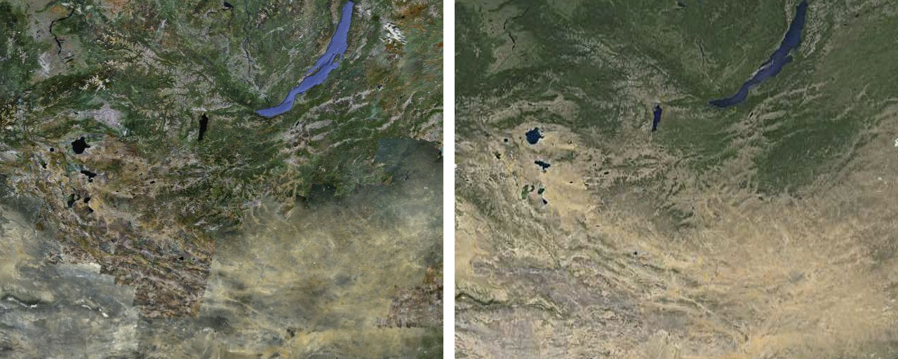
This new picture of the earth also reveals the texture of the landscape with greater clarity than ever before.

Continuing deforestation in Brazil: before and after.

We're proud of the progress we have made, but there is always room to keep improving. For example, although we have tried to minimize the impact of the stripe artifacts in the Landsat 7 images, they are still visible in some areas. There is more good news though: the new Landsat 8 satellite, launched earlier this year, promises to capture even more beautiful and up-to-date imagery in the months and years ahead.

Mongolia and surrounds, before and after.

You can see our new satellite imagery by going to Google Maps and turning on satellite view, or by launching Google Earth, and zooming out. Have fun exploring!


Posted by Matt Hancher, Tech Lead, Google Earth Engine
Read More
Posted in Google Earth, Google Earth Engine, Google Maps, imagery | No comments

Thursday, 9 May 2013

A picture of Earth through time

Posted on 04:15 by Unknown
(Cross posted on Official Google Blog)

Today, we're making it possible for you to go back in time and get a stunning historical perspective on the changes to the Earth’s surface over time. Working with the U.S. Geological Survey (USGS), NASA and TIME, we're releasing more than a quarter-century of images of Earth taken from space, compiled for the first time into an interactive time-lapse experience. We believe this is the most comprehensive picture of our changing planet ever made available to the public.

Built from millions of satellite images and trillions of pixels, you can explore this global, zoomable time-lapse map as part of TIME's new Timelapse project. View stunning phenomena such as the sprouting of Dubai’s artificial Palm Islands, the retreat of Alaska’s Columbia Glacier, the deforestation of the Brazilian Amazon and urban growth in Las Vegas from 1984 to 2012:


Feel free to share these GIFs! More examples can be found on Google+.

The images were collected as part of an ongoing joint mission between the USGS and NASA called Landsat. Their satellites have been observing earth from space since the 1970s—with all of the images sent back to Earth and archived on USGS tape drives that look something like this example (courtesy of the USGS).

We started working with the USGS in 2009 to make this historic archive of earth imagery available online. Using Google Earth Engine technology, we sifted through 2,068,467 images—a total of 909 terabytes of data—to find the highest-quality pixels (e.g., those without clouds), for every year since 1984 and for every spot on Earth. We then compiled these into enormous planetary images, 1.78 terapixels each, one for each year.

As the final step, we worked with the CREATE Lab at Carnegie Mellon University, recipients of a Google Focused Research Award, to convert these annual Earth images into a seamless, browsable HTML5 animation. Check it out on the Google’s Timelapse website.

Much like the iconic image of Earth from the Apollo 17 mission—which had a profound effect on many of us—this time-lapse map is not only fascinating to explore, but we also hope it can inform the global community’s thinking about how we live on our planet and the policies that will guide us in the future. A special thanks to all our partners who helped us to make this happen.

Posted by Rebecca Moore, Engineering Manager, Google Earth Engine & Earth Outreach
Read More
Posted in Google Earth, Google Earth Engine, imagery | No comments

Wednesday, 12 September 2012

Elephants in Peril

Posted on 13:39 by Unknown

Editor’s note: Today’s guest authors are Rob Heittman from Solertium, Inc., a technical development company and Iain Douglas-Hamilton, founder of Save the Elephants, based in Kenya. Save the Elephants was the recipient of a Google Earth Outreach Developer Grant, funded through the Google Inc. Charitable Giving Fund at the Tides Foundation. We’re hoping that mapping data patterns over time will shed much-needed light on the recent dramatic increase in poaching of elephants in Africa.

History is currently repeating itself in a quite unpleasant way.

Once again, as we did in the 1970s and 1980s, we are seeing previously tranquil elephants affected by huge surges in the illegal killing of elephants for ivory. We know, from past experience, that this ivory rush is fueled by a sudden increase in demand: new prosperity in Asian markets, where ordinary people can suddenly afford to buy ivory. After a relative respite since the 1989 ivory trade ban, I am sad to report that elephants are once again in peril.

Murembo, a bull elephant, from Tsavo National Park, Kenya
Photo Credit: Johan Marais

Save The Elephants operates a research camp in Samburu, Kenya; a very special place. The elephants there are protected by law, the ceaseless efforts of the Kenya Wildlife Service, local stakeholders, and amazing technology that helps secure their future. Within Samburu -- and other places in Africa -- we provide a tracking system which uses GPS radio collars to monitor the movements of elephants in near real time. Using Google Earth and our new, lightweight mobile apps, our team can be deeply knowledgeable about the Samburu elephants, and share data with the guardians to come to their aid if needed. Alerts tell us when unusual conditions occur. The most serious alert concerns immobility. This too often means another poaching incident, and another elephant's life lost to runaway demand for ivory.


Save the Elephants’ private Android and iOS apps allow for real-time elephant tracking, alerting rangers to elephants movements and poaching incidents.

We believe the ivory poaching we're seeing is a microcosm of what is going on across Africa. This past year, especially, there have been a series of massacres, for example, one in Cameroon in which almost an entire population was wiped out with automatic weapons.


Just 10 years ago, the areas in red, where illegal elephant killing is peaking, were showing healthy or stable elephant populations in green. Explore the changes over time in the timelapse feature.  Since 2008, major deterioration set in.

The other necessary part of the solution is to reduce the demand. Here, technology can also be a powerful ally. We are now using new Google technologies to bring the same level of awareness to anyone with a Web browser. With our most recent initiative, the Elephants in Peril site (http://www.elephantsinperil.org), we have turned to Fusion Tables and Google Maps Engine to do two important things. First, we are working to bring together public data sets, often buried in boring official reports, to reveal the complete story of elephant populations over time, map them out, and understand what trends can be seen. Second, we aim to share the real, unvarnished scientific data from whatever sources in a citable, and highly usable form.

As long as elephants continue to be threatened by surging ivory demand, we want Elephants in Peril to become a reliable source, whether a visitor wants to learn about the problem, write, tell about it, or take steps to help solve it. Google's simple data publishing and visualization tools make it possible for us to undertake this effort and reach a larger audience than would otherwise be possible.


elephantsinperil.org map shows main populations left in Africa with green being high density and red being low density.

We are in a race with the poachers; a race we have to win. Google Earth, Google Maps Engine, and Fusion Tables give us the advantage of speed. Already, we have used the system to share results with the media, and save weeks or months in achieving publicity. Later this year, we will publish original research that helps to tie our findings in Samburu to the challenges across the African continent, using the site to engage concerned individuals, NGOs and governments. In future, we look forward to translating the site into Chinese to improve its utility as a resource in Asia.

Google Earth Outreach and the Tides Foundation have made our mobile apps and Elephants in Peril possible. We welcome the assistance of any concerned Google developers or users. Please visit our website; even better, visit us in Africa if you can, and give us your ideas to help us win this race.

Posted by Dr. Iain Douglas-Hamilton, Founder of Save the Elephants, and Rob Heittman, CTO of Solertium, Inc.
Read More
Posted in Africa, earth outreach, Google Earth, Google Earth Engine, Google Maps | No comments

Monday, 23 July 2012

Forty years of our planet, from space

Posted on 09:09 by Unknown

Today we celebrate the 40th anniversary of the Landsat satellite program -- now the longest-running continuous acquisition of satellite images of the Earth's surface. Over the years, Landsat has collected petabytes of images offering an historic perspective on planetary change that can help scientists, independent researchers, and nations make informed economic and environmental policy decisions.

We’re working with the USGS and Carnegie Mellon University, to make parts of this enormous collection of imagery available to the public in timelapse videos of the Earth's surface. With them you can travel through time, from 1999-2011, to see the transformation of our planet. Whether it’s deforestation in the Amazon, urban growth in Las Vegas or the difference in snow coverage between the seasons. Here are a few highlights.

Landsat timelapse tour of the Amazon rainforest shows the spread of deforestation between 1999 (left) and 2011 (right).

The rapid growth of Las Vegas, Nevada between 1999 (left) and 2011 (right) is visible in the Landsat timelapse tour.

A seasonal timelapse created using MODIS imagery, where every video frame represents about one week. This shows snow-cover differences over the U.S. between February and August, 2002.

We believe these may be the largest video frames ever created. If you could see the entire video at full resolution, a single frame would be 1.78 terapixels which is 18 football fields' worth of computer screens laid side-by-side.

In 2008, the USGS opened access to the entire Landsat archive for free. Google Earth Engine makes it possible for this data to be accessed and used by scientists and others no matter where they are in the world. Watch the video below to learn more about the history of the Landsat program and how Google Earth Engine was used to process and analyze this enormous archive of planetary imagery.


Happy 40th, Landsat! We're proud to be making this vast archive available to the public, and to be enabling deep analysis of this data by scientists and policymakers all over the world. Head over to the Google Earth Engine site to experience all the fully interactive tours of these timelapse videos.

Posted by Eric Nguyen, Software Engineer for Earth Engine and Randy Sargent, Visiting Researcher from Carnegie Mellon University
Read More
Posted in Google Earth, Google Earth Engine, imagery | No comments
Older Posts Home
Subscribe to: Posts (Atom)

Popular Posts

  • Help improve the “blue dot” for people visiting your venue
    When we announced the availability of indoor maps for Android last November , we also introduced Google Maps Floor Plans as a tool for busi...
  • Take off for the holidays with Google Street View
    Whether it’s touring the canals of Venice , swimming with the seals in the Galapagos or climbing the Burj Khalifa in Dubai, Street View ha...
  • Follow in Darwin's footsteps with the iNaturalist mobile app
    Editor’s Note: Today’s guest author is Dr. Scott Loarie, a fellow at the Carnegie Institution for Science at Stanford and co-director of iN...
  • Imagery Update: Week of August 29th
    The Google Earth and Google Maps Imagery Team has published their latest batch of aerial and satellite imagery! In this blog post, we’d li...
  • Imagery Update - Week of May 16th
    The Google Earth and Google Maps Imagery Team has just published its latest batch of satellite and aerial imagery, and as always, there ar...
  • Imagery Update: Week of November 28th
    The winter and holiday seasons are quickly approaching but that hasn’t stopped the Google Earth and Maps Imagery Team from updating aerial...
  • A clearer view of the seafloor in Google Earth
    More than two-thirds of Earth is covered by oceans. If you drained all of that water away, you'd see huge basins that have never been ex...
  • Imagery Update - Week of May 31st
    The Google Earth and Google Maps Imagery Team has just published its first batch of satellite and aerial imagery for June, and as always, ...
  • Celebrate Kisses Across Canada
    First kisses, last kisses and all those kisses in between... here’s your chance to kiss and tell! Just in time for Valentine’s Day, the Cana...
  • Imagery Update: Week of August 15th
    The Google Earth and Google Maps Imagery Team just published a new batch of aerial and satellite imagery, and as always, there’s all kinds...

Categories

  • #treasuremap
  • +1
  • 3D
  • 8bitmaps
  • Adwords Express
  • Africa
  • Amazon
  • Andorra
  • Android
  • api
  • Art Project
  • Audi
  • biking
  • Boost
  • Boulder
  • Brazil
  • Bulgaria
  • Business Photos
  • Canada
  • check-in
  • community
  • competition
  • contest
  • crisis response
  • Culture
  • custom maps
  • developer
  • Developers
  • directions
  • disaster response
  • discovery
  • Download Free Nokia 6680 PC Suite
  • Download Micromax pc suite
  • Download Micromax pc suite for window
  • Download micromax Q5 Pc suite
  • Download PC suite
  • Download Samsung Mobile Pc Suite
  • earth outreach
  • education
  • Enterprise
  • Estonia
  • Europe
  • Fusion Tables
  • galaxy s2
  • Gibraltar
  • GMM
  • google
  • Google Earth
  • Google Earth Engine
  • Google Map Maker
  • Google Maps
  • Google Maps API
  • Google Maps Engine
  • Google Maps for Mobile
  • Google Maps Navigation
  • Google Maps Transit
  • Google Places
  • Google Plus
  • Google Search
  • Google Street View
  • google.org
  • Google+
  • googlenew
  • Grand Canyon
  • ground truth
  • Halloween
  • historical
  • history
  • Hotpot
  • HTC PC Suite Download
  • HTC PC suite for WIN 7
  • HTC PC Suite Free Download
  • HTC sync Downlaod
  • HTC Sync Download for windows
  • HTC Sync Free Download
  • Hungary
  • imager
  • imagery
  • Indoor Maps
  • iPhone
  • Iraq
  • Japan
  • Latitude
  • Latvia
  • layers
  • LG Mobile PC Suite
  • LG Mobile Support Tool
  • LG PC suite Download
  • Lithuania
  • London
  • Malaysia
  • Mall of America
  • Map Maker
  • mapsgl
  • Matt Harding
  • Mexico
  • Micromax A110
  • Micromax Canvas 2
  • Micromax pc suite download
  • Micromax PC suite for windows
  • Micromax Q5 FB PC Suite Free Download
  • Micromax Q5 FB PC Suite Free Download For Windows
  • Mircromax Q3 PC Suite Download for windows
  • Mobile
  • Monticello
  • My Maps
  • my places
  • my tracks
  • navigation
  • new Google Maps
  • Nokia 5250 PC Suite Free Download
  • Nokia 5530 PC Suite Free Download
  • Nokia 5610 PC Suite Free Download
  • Nokia 5800 PC Suite Free Download
  • Nokia 6030 PC Suite Free Download
  • Nokia 6680 PC Suite Download for windows
  • Nokia 6680 PC suite free Download
  • Nokia Asha 305
  • Nokia Asha 306 PC Suite download
  • Nokia C3-01
  • Nokia Free Suite
  • Nokia Mobile PC suite Download
  • oblique imagery
  • ocean
  • offline maps
  • Outreach
  • Pakistan
  • Panoramio
  • Parks Canada
  • Pegman
  • photo tours
  • photos
  • picasa
  • Quiz
  • real estate
  • Russia
  • Samsung C3322 PC Suite Free Download
  • Samsung C6712 PC Suite Free Download
  • Samsung Corby 2 PC Suite Free Download
  • Samsung Galaxy
  • Samsung Galaxy 5830 PC Suite Download
  • Samsung Galaxy Ace Hugo Boss
  • Samsung Galaxy Ace PC Suite Download
  • Samsung galaxy I8190 S III PC Suite Download
  • samsung galaxy mega
  • Samsung Galaxy Mega 5.8
  • Samsung Galaxy Mega 6.3
  • samsung galaxy s2
  • Samsung Galaxy Stratosphere II I415
  • samsung GT-I9100 pc suite
  • Samsung GT-S6102 Galaxy Y Duos PC Suite Download
  • Samsung GT-S6102 PC Suite Download
  • Samsung I9000 Galaxy S PC Suite Download
  • Samsung mobile pc suite downlaod
  • samsung mobile pc suite download for Windows 7 ad XP
  • samsung mobile pc suite download for Windows 7 and XP
  • Samsung N7100
  • Samsung Note 2
  • Samsung Note II
  • Samsung PC Suite Download.
  • Samsung Wave Y Drivers Download
  • Samsung Wave Y PC Suite Free Download
  • Santa
  • Santa Tracker
  • search stories
  • SketchUp
  • Slovakia
  • Slovenia
  • Sony PC Companion Free Download
  • Sony PC Suite Free Download
  • South Sudan
  • space
  • Spain
  • sports
  • Street View
  • Sumsang C3322 Drivers Download
  • SXSW
  • Tags
  • Thomas Jefferson
  • Thomas Jefferson Foundation
  • Tip of the week
  • tour guide
  • traffic
  • Train
  • Transit
  • trees
  • Trekker
  • U.S. National Park Service
  • Ukraine
  • University of Virginia
  • voice search
  • walking
  • Waze
  • weather
  • webgl
  • Xperia PC Suite Download
  • zagat

Blog Archive

  • ▼  2013 (87)
    • ▼  November (7)
      • Take off for the holidays with Google Street View
      • Take a hike with Street View through U.S. National...
      • Street View floats into Venice
      • Mapping the world’s deforestation over time
      • Meet nonprofits using “Geo for Good”
      • Tour Builder: Tell your stories with Google Earth
      • From where you are to where you want to go
    • ►  October (3)
    • ►  September (4)
    • ►  August (9)
    • ►  July (13)
    • ►  June (12)
    • ►  May (10)
    • ►  April (9)
    • ►  March (11)
    • ►  February (2)
    • ►  January (7)
  • ►  2012 (192)
    • ►  December (9)
    • ►  November (5)
    • ►  October (24)
    • ►  September (13)
    • ►  August (15)
    • ►  July (18)
    • ►  June (21)
    • ►  May (17)
    • ►  April (19)
    • ►  March (26)
    • ►  February (12)
    • ►  January (13)
  • ►  2011 (234)
    • ►  December (13)
    • ►  November (17)
    • ►  October (19)
    • ►  September (15)
    • ►  August (23)
    • ►  July (25)
    • ►  June (20)
    • ►  May (20)
    • ►  April (23)
    • ►  March (24)
    • ►  February (18)
    • ►  January (17)
  • ►  2010 (21)
    • ►  December (21)
Powered by Blogger.

About Me

Unknown
View my complete profile