Your Mobile Support

  • Subscribe to our RSS feed.
  • Twitter
  • StumbleUpon
  • Reddit
  • Facebook
  • Digg

Monday, 23 January 2012

New 45° imagery available for 24 cities

Posted on 17:31 by Unknown

The second 45° imagery update of 2012 includes new imagery for 17 U.S. and 7 international locations in Google Maps.

Ulm is a university town in southern Germany, located at the Danube river. One of the most famous buildings in this town is the Ulm Minster in Gothic style which measures more than 160 meters in height. Climbing the 768 steps to the top platform, visitors will see a breathtaking panoramic view of the Alps on clear days.


View Larger Map


Cleveland, Ohio is an important hub at the southern rim of Lake Erie. Many banks, insurance companies, and healthcare firms are headquartered here; this is also the home of the famous Rock’n’Roll Hall of Fame:


View Larger Map


In the southern hemisphere, we’ve published imagery of Porto Alegre in the very south of Brazil. It has more than one million inhabitants. The many parks in Porto Alegre makes this city one of the most beautiful in all of Latin America.


View Larger Map


Have fun exploring the new sites!

Here is a list of updated cities:

US:
Boise/Caldwell, ID; Buffalo, NY; Chattanooga, TN; Cleveland, OH; Denver, CO; Greenville, SC; Houston/Pasadena, TX; Kansas City/Gladstone, MS; Knoxville/Louisville, TN; Memphis/Bartlett, TN; Mobile, AL; Nashville, TN; Pensacola, FL; Racine, WI; Santa Monica, CA; Sarasota/Englewood, FL; Stockton, CA

Europe:
Baiona, Spain; Basel, Switzerland; Friedberg, Germany; Mannheim, Germany; Santander, Spain; Ulm, Germany

South America:
Porto Alegre, Brazil

Posted by Bernd Steinert, Geo Data Specialist
Read More
Posted in | No comments

Thursday, 19 January 2012

Biodiversity on the move

Posted on 12:00 by Unknown

Editor’s Note: Today’s guest author is Ari Daniel Shapiro from Atlantic Public Media (APM), a non-profit public media organization in Woods Hole, Massachusetts. APM was the recipient of a Google Earth Outreach Developer Grant, funded through the Google Inc. Charitable Giving Fund at the Tides Foundation. We’re excited to showcase how Atlantic Public Media has weaved Google Earth and KML tours into engaging stories about the diversity of life.

Life gets around. Tiny Arctic Terns soar from the Arctic to the Antarctic, and back, in a single year. A kind of sea algae known as “sea grapes” roam from Australia to the Mediterranean as stowaways, and then promptly conquer their new home.

As a radio producer, I’m used to telling these kinds of stories with audio, weaving together interview tape, ambient sound, and narration. For the last two years, I’ve worked with Atlantic Public Media and the Encyclopedia of Life (EOL) to produce an audio series entitled One Species at a Time. Each episode pays homage to a different organism that gallops or creeps or pulses on our planet. We collaborate on these stories with Marie Studer, the EOL's Learning and Education Director, who has championed our podcast as way to make the natural world come alive and generate excitement amongst people who want to learn about it and explore.

While our podcast and public radio programming brought these tales of the natural world to listeners all over the planet, we always look for ways to tell these stories better and share them more widely. Eduardo Garcia Milagros, a biologist and KML developer in Spain, approached us last year with the idea to use Google Earth as a platform for these mini-documentaries. Brimming with enthusiasm, he shared “When I first opened Google Earth, I went to see my hometown. Once I started exploring KML capabilities, I realized that Google Earth can be an amazing educational tool, especially when you have a good story.” Inspired by his excitement, we decided to identify species whose stories could really be best illustrated through a map, such as the Arctic Tern’s annual migration.

Our tour on Arctic terns can be viewed on YouTube or downloaded and explored in Google Earth.

Incorporating Google Earth into our narratives proved to be an interesting challenge for me and Jay Allison, my editor on the project and the Executive Director of APM. We wanted to make the most of the map as a medium to bring to life the tale of the Arctic Tern and other species for viewers. By integrating geographic animation and imagery from all over the world with the audio and images from contributing scientists, we were able to support and enhance the story. For example, in the sea algae tour below, we circle the globe to the Amazon rainforest to illustrate a phenomenon in the ecology of the Mediterranean.

Our sea algae tour can also be found on YouTube or downloaded for viewing in Google Earth.

These tours combine voice, sound, images, video, and data-driven animations to explain how two creatures have been able to travel so much of our planet. Coming from a public radio documentary background, we tend to approach things from a purely narrative or poetic angle, but Google Earth tours allow for audio/visual dialogue as well. The movement isn't purely in the story. The map can become part of a “conversation,” and we're just beginning to explore the possibilities.

We hope to produce more of these Biodiversity on the Move tours in the future; we’d like to hear what you think of them and what we can improve next time. Drop us a line on the Encyclopedia of Life blog.

Posted by Ari Daniel Shapiro, Atlantic Public Media and the Encyclopedia of Life
Read More
Posted in Google Earth, Outreach | No comments

Monday, 16 January 2012

World Bank and Google join forces to empower mapping communities around the world

Posted on 08:34 by Unknown

Today the World Bank and Google announced a collaborative agreement aimed at improving disaster preparedness and development efforts in countries around the world.

Under this agreement, the World Bank will act as a conduit to make Google Map Maker source data more widely and easily available to government organizations in the event of major disasters, and also for improved planning, management, and monitoring of public services provision.

The free, web-based mapping tool called Google Map Maker enables citizens to directly participate in the creation of maps by contributing their local knowledge. Once approved, those additions are then reflected on Google Maps and Google Earth for others around the world to see.

The Google Map Maker data includes detailed maps of more than 150 countries and regions, and identifies locations like schools, hospitals, roads, settlements and water points that are critical for relief workers to know about in times of crisis. The data will also be useful for planning purposes, as governments and their development partners can use the information to monitor public services, infrastructure and development projects; make them more transparent for NGOs, researchers, and individual citizens; and more effectively identify areas that might be in need of assistance before a disaster strikes.

Community mapper in Kampala, Uganda

World Bank partner organizations, which include government and United Nations agencies, will be able to contact World Bank offices for possible access to the Google Map Maker data for their various projects. World Bank country offices in Kenya, South Sudan, Tanzania, Sierra Leone, Ghana, Zambia, Nigeria, Democratic Republic of Congo, Moldova, Mozambique, Nepal, and Haiti plan to pilot the Map Maker agreement.

The World Bank Institute (WBI) and the Global Facility for Disaster Reduction and Recovery (GFDRR) will manage the World Bank’s involvement in the collaboration, building on previous joint mapping efforts. For example in April 2011, members of the Southern Sudanese Diaspora participated in a series of community mapping events organized by World Bank and Google to create comprehensive maps of schools, hospitals and other social infrastructure in this new country via Map Maker technology.

Google has enjoyed a strong relationship with World Bank for many years. As indicated by the World Bank Vice President for the Africa Region Obiageli Ezekwesili, “Today’s technology can empower civil society, including the diaspora, to collaborate and support the development process. This collaboration is about shifting the emphasis from organizations to people, and empowering them to solve their own problems and develop their own solutions using maps.”

France Lamy, Program Manager, Google.org
Read More
Posted in google.org, Map Maker | No comments

Friday, 13 January 2012

Imagery Update: Week of January 9th

Posted on 15:15 by Unknown

Update (January 23, 2012): Some imagery was not included in the last update as expected. The following countries received updated imagery: Algeria, Argentina, Australia, Austria, Bangladesh, Bolivia, Bosnia and Herzegovina, Brazil, Canada, Chile, China, Cuba, Côte d'Ivoire, Democratic Republic of the Congo, Egypt, Ethiopia, France, Germany, Greenland, India, Indonesia, Iran, Ireland, Italy, Japan, Kenya, Lebanon, Libya, Madagascar, Mali, Mexico, Moldova, Morocco, Nepal, New Zealand, Nigeria, North Korea, Pakistan, Peru, Philippines, Qatar, Romania, Russia, Saudi Arabia, Senegal, Slovakia, South Africa, Svalbard, Syria, Thailand, Trinidad and Tobago, Turkey, Uganda, United States, Wake Island, Yemen

It’s a new year and what better way to usher it in than with new aerial and satellite imagery published by the Google Earth and Maps Imagery Team! In this post, we’ll explore several international features captured in this latest update.

Our first example is part of an aerial image acquired last August of the central park grounds, fountain, and wasserturm (water tower) of Mannheim, Germany. Mannheim is the city where Karl Benz built and tested the world’s first automobile.

Mannheim Water Tower, Mannheim, Germany

Our next aerial example, also acquired last August, shows the water parks of Linz, Austria, adjacent to the Danube River. The park makes up part of the "Kulturmeile" ("culture mile") that includes museums and concert halls.

Sun and water bathers, Linz, Austria

The satellite image below shows the medieval grounds and structures of one of the oldest castles in the world, the Citadel of Aleppo in Syria. The citadel sits on a large hill that has been in use since the 3rd millenium BC, and is outlined by perimeter walls and a foundation that reaches 50 meters in height.

Citadel of Aleppo, Syria

This next satellite image highlights a section of the Great Wall of China in Badaling, Yanqing County, China. This site is the most visited section of the wall, and hosted U.S. President Nixon and Vice Premier Li Xiannian during Nixon’s historic visit to China.

Section of the Great Wall of China in Badaling, Yanqing County, China

Lastly, shown below is a satellite image of the National Synchrotron Radiation Research Center, in Dong, Taiwan. Shown at bottom center is the partially built circular Taiwan Photon Source facility, due to be completed in 2013.

National Synchrotron Radiation Center, Dong, Taiwan

If you’d like to receive an email notification when the Google Earth and Maps Imagery team updates your favorite site(s), we’ve got just the tool: The Follow Your World application!

These are only a few examples of the types of features that can be seen and discovered in our latest batch of published imagery. Happy exploring!

High resolution aerial updates:
USA: Baton Rouge, LA; Brady, TX; Downieville, CA; East Bay, CA; El Paso, TX; Greenwood, MS; Greenwood, SC; Kingman AZ; Level Land, TX; Long View, TX; Lufkin, TX; Ozona, TX; Quincy, CA; Radium Springs, NM; San Angelo, TX

Austria: Innsbruck, Linz,
Germany: Augsburg, Mannheim

Countries/regions receiving high resolution satellite updates:
Algeria, Argentina, Australia, Austria, Bangladesh, Belarus, Benin, Bhutan, Bolivia, Botswana, Brazil, Bulgaria, Burkina Faso, Burundi, Cameroon, Canada, Cape Verde, Central African Republic, Chad, Chile, China, Colombia, Comoros, Costa Rica, Croatia, Cuba, Cyprus, Czech Republic, Côte d'Ivoire, Democratic Republic of the Congo, Djibouti, Dominican Republic, Ecuador, Egypt, Eritrea, Ethiopia, Finland, France, French Polynesia, Germany, Ghana, Greece, Greenland, Guatemala, Guinea, Haiti, Honduras, Hungary, India, Indonesia, Iran, Ireland, Italy, Japan, Jordan, Kazakhstan, Kenya, Kuwait, Lesotho, Libya, Madagascar, Malawi, Marshall Islands, Mexico, Mongolia, Morocco, Mozambique, Myanmar, Namibia, Nepal, New Zealand, Niger, Nigeria, North Korea, Oman, Pakistan, Papua New Guinea, Paraguay, Peru, Philippines, Poland, Portugal, Qatar, Republic of Korea, Romania, Russia, Rwanda, Saudi Arabia, Senegal, Serbia, Sierra Leone, Slovakia, Somalia, South Africa, Spain, Sri Lanka, Sudan, Svalbard, Swaziland, Sweden, Switzerland, Syria, Tajikistan, Tanzania, Thailand, Togo, Tunisia, Turkey, Uganda, Ukraine, United Arab Emirates, United Kingdom, United States, Uruguay, Uzbekistan, Venezuela, Vietnam, West Bank, Yemen, Zambia, Zimbabwe

These updates are now available in both Google Maps and Google Earth. For a complete picture of where we updated imagery, download this KML for viewing in Google Earth.

Posted by Eric Kolb, Geo Data Strategist
Read More
Posted in Google Earth, imagery | No comments

Thursday, 12 January 2012

Explore your world, start here.

Posted on 06:40 by Unknown

Google has always been on a mission to help organize the world’s information, and our Google Maps and Google Earth teams constantly work to apply this to place and space. A quick retrospective look at 2011 shows a number of improvements to help our users discover and experience new places around the world, both digitally and in person.

To start, we’ve continued to add new satellite and 45 degree imagery on Google Maps and Google Earth, which reached 1B downloads last year, as well as expand our imagery coverage of Street View to Belgium, business interiors, partner locations like parks and even museums with the Art Project. If you want to follow these imagery updates, we expanded Follow Your World so you can get notifications about locations that interest you.

You may have also noticed improvements to the look and feel of our maps, especially with 3D buildings across the world (e.g. Rome, Italy) and smoother transitions with the introduction of Google MapsGL. Using WebGL technology your maps experience is much better with 3D buildings, smoother transitions between imagery and the ability to instantly “swoop” into Street View without a plugin.

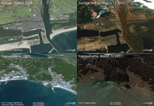
Providing the latest map data has also been an important goal, which is why we introduced Google Map Maker in the U.S. and Canada to reach a total of 188 countries where users have an easier way to contribute local knowledge. Up-to-date maps can also enable other organizations be more effective, such as relief and aid organizations who were able to access imagery after the earthquake and tsunami hit northern Japan, and organizations that use Google Earth Builder to build on top of our APIs.

Before and after the earthquake and tsunami.

And of course, your mobile device enables you to take Google Maps with you wherever you go. We recently made indoor maps available with a more accurate blue dot to help you orient yourself, as well as offline maps so you can still see a map area when you’re not connected. The video below shows some of the ways Google Maps can help through all parts of your journey.


In 2012, our goal is to continue making knowledge of the physical world more accessible and tailored to your needs. We want Google Maps and Google Earth to be your sidekick; making travel and exploration smarter and more efficient. Whether you want to map your excursion from point A to point B, find interesting detours along your way, or see new and foreign places, Google Maps can help you explore your world.

To learn more about some Google Maps features, check out our interactive tour at maps.google.com/starthere

Posted by Brian McClendon, VP of Engineering, Google Earth and Maps
Read More
Posted in Google Earth, Google Maps, imagery | No comments

Wednesday, 11 January 2012

Street View: your friendly campus tour guide

Posted on 06:00 by Unknown
(Cross posted to Official Google Blog)

For many, the start of a new year is also the start of a new semester. Whether you’re a current student trying to familiarize yourself with campus, an applicant assessing your options or an alumnus feeling nostalgic, the Street View feature in Google Maps can be your tour guide without the backward walking. We recently added imagery of more university campuses to the existing special collections already available via Street View through our Partner Program. Let’s take a quick tour of some of the many beautiful campuses around the world.

In Tokyo’s Shinjuku ward, you can find Waseda University. Founded in 1882, it is known for producing some of the top Japanese politicians and business leaders in recent history. Check out the statue of Ōkuma Shigenobu, who founded the university.

View Larger Map

Halfway around the world, we can visit the University of Glasgow in Scotland. Founded in 1451, this university is one of the oldest in the world, and the fourth oldest in the English speaking world. Take a tour of the magnificent campus starting at the West Quadrangle of the Main Building.

View Larger Map

Hop the Atlantic and cross the U.S. to Stanford University, which was founded in 1891 in Palo Alto, Calif. Located near Google’s headquarters in Mountain View, both of our founders, Larry Page and Sergey Brin, attended Stanford for their graduate studies. Explore the campus starting at the palm-lined main quad with a view of Hoover Tower.

View Larger Map

Students, take note: Even though your campus is now available in your browser, you still need to go to class! To view other imagery collections of popular universities around the world see a complete list of the campuses or visit a few more highlights in the Street View gallery.

Posted by Chris Fiock, Program Manager for Street View
Read More
Posted in imagery, Street View | No comments

Tuesday, 10 January 2012

Get indoor maps of Las Vegas Casinos, the Convention Center and more

Posted on 09:05 by Unknown

At the 2012 Consumer Electronic Show (CES) in Las Vegas, NV, attendees will now be able to use Google Maps on their Android devices to help them find their way in the sea of exhibitors and attractions throughout the Las Vegas Convention Center, select resorts and casinos along the Las Vegas strip, as well as the Las Vegas McCarran International Airport.

Las Vegas Convention Center with CES Exhibitors

Since November of last year, you’ve been able to use Google Maps in select places to get detailed floor plans and indoor location information within a few meters, as well as an accurate floor level location. Today, we’ve expanded the list of places with indoor maps by partnering with MGM Resorts International, Caesars Entertainment and others, to provide indoor maps for Caesars Palace, Bellagio, The Venetian, The Palazzo, MGM Grand and many more.

We hope that these indoor maps will come in handy when finding your way through the slots and to the shops. And for those of you who catch gadget-fever with CES in town, we've also partnered with a number of Best Buy stores in the Las Vegas area. For more detailed list of indoor maps partners, go to our help center or to see a demo, start here.

Left: MGM Grand Hotel and Casino, Right: Caesars Palace

Starting today, we’re also releasing some of the first floor plans in Google Maps that were uploaded through the Google Maps Floor Plans tool. From malls to convention centers, museums and educational institutions from California to New York you will now be able to see these floor plans in Google Maps for Android.

So the next time you are looking for the perfect table to win the jackpot or can’t find the nearest restroom, simply open Google Maps on your Android device and let indoor maps show you the way. If you’re attending CES, please come by the the Google Maps booth to learn more and preview our upcoming Google Maps game!


Posted by Brian McClendon, VP of Engineering, Google Earth and Maps
Read More
Posted in Google Maps, Indoor Maps | No comments
Newer Posts Older Posts Home
Subscribe to: Posts (Atom)

Popular Posts

  • Help improve the “blue dot” for people visiting your venue
    When we announced the availability of indoor maps for Android last November , we also introduced Google Maps Floor Plans as a tool for busi...
  • Take off for the holidays with Google Street View
    Whether it’s touring the canals of Venice , swimming with the seals in the Galapagos or climbing the Burj Khalifa in Dubai, Street View ha...
  • Imagery Update - Week of May 16th
    The Google Earth and Google Maps Imagery Team has just published its latest batch of satellite and aerial imagery, and as always, there ar...
  • Imagery Update - Week of May 31st
    The Google Earth and Google Maps Imagery Team has just published its first batch of satellite and aerial imagery for June, and as always, ...
  • Welcome to the world’s largest intact forest: Canada’s boreal
    Editor’s Note: Today's guest author is Steve Kallick, from the Pew Environment Group’s International Boreal Conservation Campaign. We ar...
  • Why maps matter: Using digital cartography tools to change the world
    People have created maps since early civilization, but only recently have digital mapping tools like Google Earth and Maps made it easy to...
  • Imagery Update: Week of August 29th
    The Google Earth and Google Maps Imagery Team has published their latest batch of aerial and satellite imagery! In this blog post, we’d li...
  • Take a trip to the Super Bowl with Google Earth
    We’re two days away from one of my favorite events of the year, the Super Bowl (and I’m sure I’m not alone!). I’m one of those fans who star...
  • Traffic and Transit Come to Google Maps in Malaysia
    We originally launched Google Maps in Malaysia back in 2009, and since then, Malaysians have been avid users of the service on both their d...
  • Google Maps Roundup for September: Making Google Maps even better for you
    As always, we’re focused on making Google Maps the best it can be for people around the world. In September, we added many new features to G...

Categories

  • #treasuremap
  • +1
  • 3D
  • 8bitmaps
  • Adwords Express
  • Africa
  • Amazon
  • Andorra
  • Android
  • api
  • Art Project
  • Audi
  • biking
  • Boost
  • Boulder
  • Brazil
  • Bulgaria
  • Business Photos
  • Canada
  • check-in
  • community
  • competition
  • contest
  • crisis response
  • Culture
  • custom maps
  • developer
  • Developers
  • directions
  • disaster response
  • discovery
  • Download Free Nokia 6680 PC Suite
  • Download Micromax pc suite
  • Download Micromax pc suite for window
  • Download micromax Q5 Pc suite
  • Download PC suite
  • Download Samsung Mobile Pc Suite
  • earth outreach
  • education
  • Enterprise
  • Estonia
  • Europe
  • Fusion Tables
  • galaxy s2
  • Gibraltar
  • GMM
  • google
  • Google Earth
  • Google Earth Engine
  • Google Map Maker
  • Google Maps
  • Google Maps API
  • Google Maps Engine
  • Google Maps for Mobile
  • Google Maps Navigation
  • Google Maps Transit
  • Google Places
  • Google Plus
  • Google Search
  • Google Street View
  • google.org
  • Google+
  • googlenew
  • Grand Canyon
  • ground truth
  • Halloween
  • historical
  • history
  • Hotpot
  • HTC PC Suite Download
  • HTC PC suite for WIN 7
  • HTC PC Suite Free Download
  • HTC sync Downlaod
  • HTC Sync Download for windows
  • HTC Sync Free Download
  • Hungary
  • imager
  • imagery
  • Indoor Maps
  • iPhone
  • Iraq
  • Japan
  • Latitude
  • Latvia
  • layers
  • LG Mobile PC Suite
  • LG Mobile Support Tool
  • LG PC suite Download
  • Lithuania
  • London
  • Malaysia
  • Mall of America
  • Map Maker
  • mapsgl
  • Matt Harding
  • Mexico
  • Micromax A110
  • Micromax Canvas 2
  • Micromax pc suite download
  • Micromax PC suite for windows
  • Micromax Q5 FB PC Suite Free Download
  • Micromax Q5 FB PC Suite Free Download For Windows
  • Mircromax Q3 PC Suite Download for windows
  • Mobile
  • Monticello
  • My Maps
  • my places
  • my tracks
  • navigation
  • new Google Maps
  • Nokia 5250 PC Suite Free Download
  • Nokia 5530 PC Suite Free Download
  • Nokia 5610 PC Suite Free Download
  • Nokia 5800 PC Suite Free Download
  • Nokia 6030 PC Suite Free Download
  • Nokia 6680 PC Suite Download for windows
  • Nokia 6680 PC suite free Download
  • Nokia Asha 305
  • Nokia Asha 306 PC Suite download
  • Nokia C3-01
  • Nokia Free Suite
  • Nokia Mobile PC suite Download
  • oblique imagery
  • ocean
  • offline maps
  • Outreach
  • Pakistan
  • Panoramio
  • Parks Canada
  • Pegman
  • photo tours
  • photos
  • picasa
  • Quiz
  • real estate
  • Russia
  • Samsung C3322 PC Suite Free Download
  • Samsung C6712 PC Suite Free Download
  • Samsung Corby 2 PC Suite Free Download
  • Samsung Galaxy
  • Samsung Galaxy 5830 PC Suite Download
  • Samsung Galaxy Ace Hugo Boss
  • Samsung Galaxy Ace PC Suite Download
  • Samsung galaxy I8190 S III PC Suite Download
  • samsung galaxy mega
  • Samsung Galaxy Mega 5.8
  • Samsung Galaxy Mega 6.3
  • samsung galaxy s2
  • Samsung Galaxy Stratosphere II I415
  • samsung GT-I9100 pc suite
  • Samsung GT-S6102 Galaxy Y Duos PC Suite Download
  • Samsung GT-S6102 PC Suite Download
  • Samsung I9000 Galaxy S PC Suite Download
  • Samsung mobile pc suite downlaod
  • samsung mobile pc suite download for Windows 7 ad XP
  • samsung mobile pc suite download for Windows 7 and XP
  • Samsung N7100
  • Samsung Note 2
  • Samsung Note II
  • Samsung PC Suite Download.
  • Samsung Wave Y Drivers Download
  • Samsung Wave Y PC Suite Free Download
  • Santa
  • Santa Tracker
  • search stories
  • SketchUp
  • Slovakia
  • Slovenia
  • Sony PC Companion Free Download
  • Sony PC Suite Free Download
  • South Sudan
  • space
  • Spain
  • sports
  • Street View
  • Sumsang C3322 Drivers Download
  • SXSW
  • Tags
  • Thomas Jefferson
  • Thomas Jefferson Foundation
  • Tip of the week
  • tour guide
  • traffic
  • Train
  • Transit
  • trees
  • Trekker
  • U.S. National Park Service
  • Ukraine
  • University of Virginia
  • voice search
  • walking
  • Waze
  • weather
  • webgl
  • Xperia PC Suite Download
  • zagat

Blog Archive

  • ▼  2013 (87)
    • ▼  November (7)
      • Take off for the holidays with Google Street View
      • Take a hike with Street View through U.S. National...
      • Street View floats into Venice
      • Mapping the world’s deforestation over time
      • Meet nonprofits using “Geo for Good”
      • Tour Builder: Tell your stories with Google Earth
      • From where you are to where you want to go
    • ►  October (3)
    • ►  September (4)
    • ►  August (9)
    • ►  July (13)
    • ►  June (12)
    • ►  May (10)
    • ►  April (9)
    • ►  March (11)
    • ►  February (2)
    • ►  January (7)
  • ►  2012 (192)
    • ►  December (9)
    • ►  November (5)
    • ►  October (24)
    • ►  September (13)
    • ►  August (15)
    • ►  July (18)
    • ►  June (21)
    • ►  May (17)
    • ►  April (19)
    • ►  March (26)
    • ►  February (12)
    • ►  January (13)
  • ►  2011 (234)
    • ►  December (13)
    • ►  November (17)
    • ►  October (19)
    • ►  September (15)
    • ►  August (23)
    • ►  July (25)
    • ►  June (20)
    • ►  May (20)
    • ►  April (23)
    • ►  March (24)
    • ►  February (18)
    • ►  January (17)
  • ►  2010 (21)
    • ►  December (21)
Powered by Blogger.

About Me

Unknown
View my complete profile