Your Mobile Support

  • Subscribe to our RSS feed.
  • Twitter
  • StumbleUpon
  • Reddit
  • Facebook
  • Digg

Monday, 25 November 2013

Take off for the holidays with Google Street View

Posted on 18:00 by Unknown

Whether it’s touring the canals of Venice, swimming with the seals in the Galapagos or climbing the Burj Khalifa in Dubai, Street View has taken you to some of the most beautiful and exciting places around the world.

Now, in addition to scoping out your destination, Street View can help you cut down the stress of traveling by giving you a preview of your journey, too. Our first efforts to map global transit locations include 16 international airports, over 50 train and subway stations, and even a cable car station in Hong Kong.


Here’s an interactive map so you can see the new Street View transit locations worldwide.

Now you can visit the check-in counter of your airline in Madrid, map out the way from baggage claim to the bus at Tokyo International Airport and check out where to pick up your rental car at Eindhoven Airport; you can even scope out your seat on an Emirates flight from Dubai!

Or, if you’re planning to take the train, navigate through Waterloo station so you can be one step ahead, whether you’re with a group of friends, family or a baby stroller.

Check in at Madrid Barajas, ES

Arrivals, Tokyo International Airport, JP

Eindhoven Airport, NL

Emirates A380 at Dubai Airport

Waterloo Station, London, UK

Don’t let travel logistics get you down this holiday season. With Street View, you can see how to get where you’re going faster and easier. Enjoy and safe travels!

Posted by Ulf Spitzer, Google Street View Program Manager
Read More
Posted in Google Street View | No comments

Wednesday, 20 November 2013

Take a hike with Street View through U.S. National Parks and Parks Canada

Posted on 03:00 by Unknown

What do tents and hiking boots have in common? You don’t need either to start exploring or planning your next adventure to some of the best national parks and historical sites across North America.

Working with the U.S. National Park Service and Parks Canada, our Street View cars, trikes and Trekker mapped more than 44 locations with beautiful, 360 degree panoramas.

Leave your gear behind and still get a chance to marvel at the Sequoias in California. Or perhaps you’re looking for more adventure? Lookout to Signal Mountain in Wyoming’s Grand Tetons, climb around California’s Joshua Tree National Park, or dip your toe into Moraine Lake in Banff, Canada.

Moraine Lake’s beautiful color comes from the light reflecting off rock flour at the bottom of the lake. (Wikipedia)

Getting tired? Take a break to watch the Old Faithful geyser in Yellowstone National Park, the first national park in the world.

Old Faithful’s eruptions last 1 1/2 to 5 minutes, expel up to 8,400 gallons of boiling water, and can be as high as 184 feet. (Yellowstone National Park)

Or, let your inner history buff come out to explore monuments and fortresses across North America.

Brush up presidential facts as you check out the Lincoln Memorial or get a closer look at US presidents at Mount Rushmore. Take a moment to “Remember the Alamo” as you visit this battlefield in Texas or step inside the Halifax Citadel to investigate the city’s role as a key naval station in the British Empire. For a selection of our favorites, check out the Views collection.

Fifty-six pillars and a pair of small triumphal arches surrounding a plaza and fountain make up the humbling World War II Memorial in Washington, D.C.

Take a moment to remember those that served at the Korean War Memorial, Vietnam Veterans Memorial and National World War II Memorial in Washington, D.C.

Whether you’re planning your next adventure or just looking to be inspired by the beauty of the world from the comfort of your living room, we invite you to head over to Google Maps and let Pegman be your virtual guide to Street View. We hope you enjoy exploring the majestic scenery of North America’s national parks and monuments.

Posted by Evan Rapoport, Product Manager, Google Maps
Read More
Posted in Google Street View, Parks Canada, U.S. National Park Service | No comments

Thursday, 14 November 2013

Street View floats into Venice

Posted on 14:00 by Unknown

Venice was once described as “undoubtedly the most beautiful city built by man,” and from these pictures it’s hard to disagree. You can now explore panoramic imagery of one of the most romantic spots in the world, captured with our Street View Trekker technology.

It was impossible for us to collect images of Venice with a Street View car or trike—blame the picturesque canals and narrow cobbled walkways—but our team of backpackers took to the streets to give Google Maps a truly Shakespearean backdrop. And not just the streets—we also loaded the Trekker onto a boat and floated by the famous gondolas to give you the best experience of Venice short of being there.

Our Trekker operator taking a well-earned rest while the gondolier does the hard work

The beautiful Piazza San Marco, where you can discover Doge's Palace, St. Marks' Cathedral, the bell tower, the Marciana National Library and the clocktower

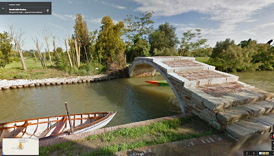
We covered a lot of ground—about 265 miles on foot and 114 miles by boat—capturing not only iconic landmarks but several hidden gems, such as the Synagogue of the first Jewish Ghetto, the Devil’s Bridge in Torcello island, a mask to scare the same Devil off the church of Santa Maria Formosa and the place where the typographer Manutius created the Italics font. Unfortunately, Street View can’t serve you a cicchetto (local appetizer) in a classic bacaro (a typical Venetian bar), though we can show you how to get there.

The Devil’s Bridge in Torcello Island

Once you’ve explored the city streets of today, you can immerse yourself in the beauty of Venice’s past by diving deep in to the artworks of the Museo Correr, which has joined the Google Cultural Institute along with Museo del Vetro and Ca’ Pesaro - International Gallery of Modern Art.

Click on a pin under "Take a Tour" to compare the modern streets with paintings of the same spots by artists such as Carpaccio and Cesare Vecellio

Or delve into historical maps of Venice, like this one showing the Frari Church, built in 1396

Finally, take a look behind the scenes showing how we captured our Street View imagery in Venice.


The Floating City is steeped in culture; it’s easy to see why it’s retained a unique fascination and romance for artists, filmmakers, musicians, playwrights and pilgrims through the centuries—and now, we hope, for Street View tourists too.

Posted by Daniele Rizzetto, Street View Operations Manager (and proud Venetian!)
Read More
Posted in Europe, Street View | No comments

Mapping the world’s deforestation over time

Posted on 11:08 by Unknown

We’re excited to announce today that, in a collaboration led by Dr. Matthew Hansen at the University of Maryland, we’ve built the first detailed maps of the world’s forests, from 2000-2012, documenting and quantifying forest landscape changes such as fires, tornadoes, disease and logging.

The most significant findings were that the overall rate of tropical deforestation is increasing, and global forests have experienced a net loss of 1.5M sq km during 2000-2012 due to both natural (disturbance) and human causes. That’s a loss of forested land comparable in size to the entire state of Alaska.

Global Forest Change, 2000-2012: individual maps of forest extent, gain, loss, and loss color-coded by year. Click to enlarge.

Sumatra has lost over 50% of its natural forest within the past 30 years. Click to enlarge.

The detailed study was published today in the journal Science, High-Resolution Global Maps of 21st-Century Forest Cover Change. Key to the study’s success was the collaboration between scientists at the University of Maryland, who developed the models to analyze Landsat satellite data, and computer scientists at Google, who then used Google Earth Engine technology to run these models on more than 650,000 Landsat images. While the analysis would have taken a single computer more than 15 years to perform, it was completed in a matter of days using Google Earth Engine.

Here are some other notable sites:


Paraguay’s Chaco woodlands within the western half of the country are experiencing rapid deforestation in the development of cattle ranches. The result is the highest rate of deforestation in the world. Click to enlarge.

The Siberian larch forests of Yakutia, Russia, are prone to fire during spring to early summer. Most of these fires are deliberately set and spread uncontrolled. Such extensive fires result in significant carbon emissions. Click to enlarge.


If you'd like to dive even deeper and learn more about this project, head on over to the Google Research blog post authored by Dr. Matt Hansen. Also, tune in next Monday, November 18 at 1:00pm ET, 10:00am PT to an online presentation and demonstration by Matt Hansen and colleagues from UMD, Google, USGS, NASA and the Moore Foundation. Please submit your questions for live Q&A.

Updated 3:30pm PDT: Corrected total sq km of net loss during 2000-2012.

Posted by Rebecca Moore and Matt Hancher, Google Earth Engine team
Read More
Posted in Google Earth Engine | No comments

Tuesday, 12 November 2013

Meet nonprofits using “Geo for Good”

Posted on 11:30 by Unknown

This week, we are excited to welcome this year’s group of nonprofit mapping specialists to the annual Geo for Good User Summit – a workshop hosted by the Google Earth Outreach team. The 4-day intensive workshop gives these do-gooder techies hands-on technical training with Google mapping tools and guidance with their projects. Out of the 75 participating organizations this year, there are some truly amazing stories to tell.

One of the attendees, Devin Dotson, is from the nonprofit American Rivers, focused on protecting and restoring the rivers of the United States. American Rivers uses maps to help tell the story of river conservation across the nation. Most recently, American Rivers made their annual announcement of the 10 rivers that are America’s Most Endangered Rivers in 2013. To illustrate these rivers, they released this map in the Google Earth Gallery, built using a Google Maps Engine software grant. The map allows the public to explore the map of the rivers and learn more about how to get involved by clicking each river.

American River’s map of America’s Most Endangered Rivers in 2013

Another Geo for Good participant is Lilian Pintea from the Jane Goodall Institute (JGI). Lilian will be sharing JGI’s story about how they’ve used mapping technology on mobile devices to monitor chimpanzee populations, habitats and human threats with local communities in Tanzania. Using this data, JGI is able to engage local communities in protecting chimpanzees and share real-time information with the world through dynamic web maps using App Engine, Fusion Tables, Google Maps API, and Open Data Kit (ODK).


Learn how the Jane Goodall Institute uses Google mapping technology to protect chimpanzees

Returning to the Summit from last year is Daniel Orellana, representing the Charles Darwin Foundation. It was during last year’s Summit that Daniel was inspired to suggest that Charles Darwin Foundation work with Google Earth Outreach to bring Street View to the Galapagos. Since the imagery was launched in September, the Charles Darwin Foundation has been working on projects to use the images for science, conservation and education. One of these projects is Darwin for a Day, which allows the public to help identify plants and animals observed when navigating through the imagery.

Daniel Orellana of Charles Darwin Foundation wearing the Street View Trekker to capture Galapagos’s volcanic beauty

To learn about Google Earth Outreach and how you can use maps to make the world a better place, head to the Google Earth Outreach website. To find out about next year’s Geo for Good or other mapping workshops, follow Google Earth Outreach on Twitter.

Raleigh Seamster, Program Manager, Google Earth Outreach
Read More
Posted in | No comments

Monday, 11 November 2013

Tour Builder: Tell your stories with Google Earth

Posted on 08:23 by Unknown
As we’ve worked with veterans and their family members on projects like Map The Fallen and VetNet, we’ve heard many amazing stories and seen how helpful storytelling can be. So we thought it might be useful to make a very simple storytelling tool. One hallway conversation led to a joint project between the Google Creative Lab and Google Earth Outreach, and today, in honor of Veterans Day, we’re excited to share Tour Builder—a simple tool for recording and sharing stories on a map.

Though originally inspired by veterans, we quickly realized that Tour Builder has the potential be a simple, useful tool for any aspiring storyteller. You could be a high school history teacher explaining the geography of the Revolutionary War, a musician updating your fans from the road, or a grandmother who wants to share her family’s story of service in WWII.


Creating a tour is easy: give it a name, add an introduction photo and a quick description. Then search the map for where your story begins and drop a placemark. Describe each place and embed photos & videos as you guide people through your story. You can dive into Street View or pick the perfect 3D view to show off your adventure.

For inspiration, just download Google Earth and explore our Gallery, which showcases some incredible journeys that have already been created using Tour Builder:
  • Elizabeth O’Herrin’s story of service in the Air National Guard from Wisconsin to Afghanistan and back.
  • The veterans of Team Rubicon who deploy emergency response teams following natural disasters like the Haiti earthquake
  • Dr. Jane Goodall's multi-generational saga of the chimpanzee “G Family” and how her Institute is protecting endangered chimpanzees with high-tech tools
  • BRAC’s efforts spreading anti-poverty solutions in 11 countries through the 100,000+ people they employ worldwide.

We invite you to try Tour Builder, and share your memories and stories with the people you love. Let us know what you think—we’d love to hear your ideas and feedback at tourbuilder-team@google.com for how Tour Builder could be a better storytelling tool and we’d love to see your tours.

Happy Veterans Day and thank you to all of the service members and military families, past and present, whose stories of service, patriotism, survival and achievement inspire us all.

Posted by Sean Askay, Google Earth Outreach, and Carrie Laureno, Google Creative Lab & Google Veterans Network
Read More
Posted in | No comments

Wednesday, 6 November 2013

From where you are to where you want to go

Posted on 10:12 by Unknown

As you gear up for the holidays, you can easily plan your vacation with the new Google Maps for desktop. With the latest updates, Earth Tours will take you on a virtual trip through cities and natural wonders in full 3D, while Street View imagery and real time traffic incidents will help to ensure smooth travels.

Explore the world with Pegman
Street View’s comprehensive imagery has always been a great way to preview your destination before arriving, but it's equally helpful when deciding where you want to go. Thanks to your feedback, we’ve made it easier to find where Street View is available, so you can explore locations in over 50 countries around the globe.

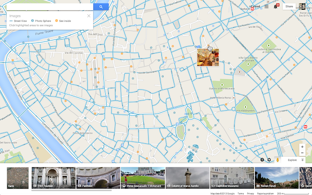
To discover a world of imagery at your fingertips, look no further than Pegman – your guide through Street View – who you can find in the lower right corner of the screen. Click on Pegman, and areas with Street View imagery will light up in blue. For a street-level preview, hover over any highlighted road, then click to dive into that location.

To see a preview before you go, click on the highlighted map

As you zoom in, you’ll also see blue circles indicating where you can find user-uploaded photos, including Photo Spheres – immersive, 360º panoramas taken from land, air, and sea. Click on a yellow circle to see inside restaurants, museums, and more. With these features, you can explore an increasing variety of locations, inside and out.

And for the Pegman fans out there, you know he's a globetrotter. Jump over to Google+ now to submit your idea for his next adventure!

New blue and yellow circles show you where to find user-uploaded images and indoor photos

Get a bird’s-eye view with Earth Tours
Explore beautiful, 3D imagery of buildings and terrain for thousands of locations from above with Earth Tours available right in your browser.* Wherever you see the Earth Tour icon, you can click, sit back, and get a virtual tour from a soaring angle. Dive into Boston or circle the Alps.

*Available on WebGL-enabled browsers, like Chrome.

Get a 3D experience wherever you see the Earth Tour icon

Navigate the roads with confidence
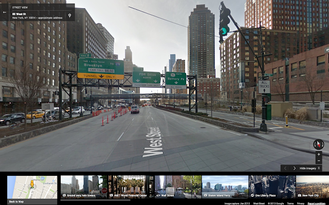
Maneuvering an unfamiliar route can be tricky when turns, exits, or tolls appear without warning. With the new step-by-step preview, you can see a street-level snapshot of each decision point to know exactly where you’re going and what to expect. Just click “Preview steps” from the directions card and advance through for a quick study of your trip, including transfers for transit.

Click on the thumbnail in the directions preview for a closer look

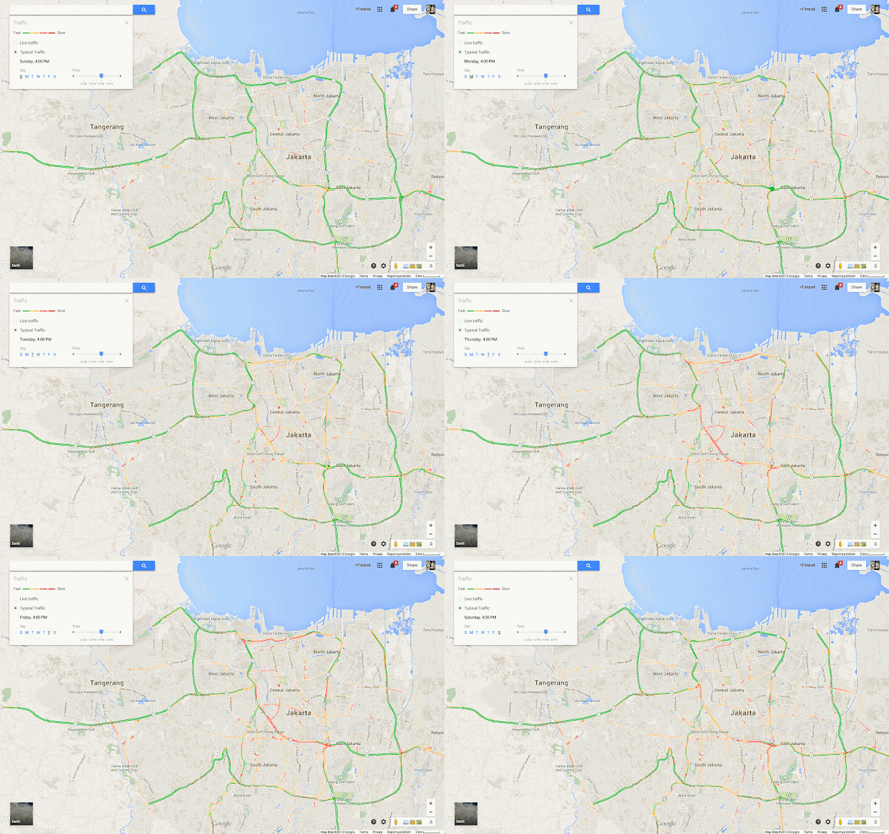
Save time commuting and navigate the roads accurately with traffic incident reports – available on desktop and mobile. When you search for driving directions, you’ll now see congestion along the route and real time incidents on the map, including data reported by Waze.

Know the road conditions before you leave

These tools are designed to help you explore and effectively navigate your world. If you’ve opted into the new Google Maps preview, these features will start rolling out today – and in the coming weeks, more of you will begin to see the new Maps experience, which you can tour below.


Posted by Kelvin Ho, Product Manager, Google Maps
Read More
Posted in Google Earth, new Google Maps, Pegman, Street View | No comments

Monday, 21 October 2013

Introducing Google Maps Engine Pro: Helping businesses create, visualize and share their data on a map

Posted on 14:32 by Unknown

(Cross-posted on the Google Enterpise Blog)

Maps are a part of our daily lives—from finding the best local Italian restaurant to planning a trip abroad. Maps are also a valuable tool in the workplace. Businesses use maps to help customers easily find their store locations or help travelers get to their final destination.

Today we’re announcing a new professional mapping tool, Google Maps Engine Pro, which lets businesses visualize their data on a map. By importing data like addresses, names, office locations and sales leads from various file formats onto a map, businesses can edit, analyze and share their information in a simple format. Google Maps Engine Pro can be as easy to use as creating a document and it gives businesses an added productivity tool to help make decisions, organize information, and plan operations using Google Maps.

With the ability to collect business information, visualize it on a map and share it across multiple devices, organizations can make better sense of data in relation to real-world surroundings. For example, Pure Fix Cycles, a distributor of custom, fixed gear bikes, uses Maps Engine Pro to identify sales opportunities across target markets, helping to expand their business throughout the U.S. and around the world.


Google Maps Engine Pro was built as an application on top of the Google Maps Engine platform, which provides businesses with cloud based technology to help them organize large datasets and create more complex maps. Today, in addition to introducing Maps Engine Pro, we’re also announcing several new features to Google Maps Engine:
  • Mobile App: The new mobile app allows individuals to access their maps created in Google Maps Engine, Maps Engine Pro and Maps Engine Lite. Once a map has been shared, users can access their data on-the-go and from any Android device.
  • Connector Tools: It’s now easy to migrate data from legacy systems, such as SAP, into Maps Engine using a connector tool that can be downloaded for free. There are more than 300+ business and geospatial applications available through the connector. To make data migration even easier, the Maps Engine now features an ESRI Toolbar that lets you transfer your ArcGIS maps to Maps Engine.
  • Introductory Account: Want to test out Google Maps Engine for your business? The introductory account is an easy way to introduce Maps Engine to your organization’s geospatial infrastructure. The free account supports the product’s full platform capabilities, including API access, but limits the number of map queries per day.
By providing better ways to easily integrate maps into your organization’s operations, businesses now have the ability to use powerful mapping technologies that were once only available to the mapping experts. With the launch of Google Maps Engine Pro and the new Google Maps Engine platform features, now every enterprise and business professional can visualize their data on a map.

Posted by Brian McClendon
Read More
Posted in | No comments

Tuesday, 15 October 2013

A long way home with help from Google Earth

Posted on 11:09 by Unknown

[Cross posted from the Official Google Blog]

In 1986, a five-year-old boy named Saroo Munshi Khan accidentally fell asleep on a stationary train in India. He woke up hours later, alone and in an unfamiliar place. This fateful train ride ripped Saroo away from his home and family. For more than a quarter century, he searched for them before finding his way back home with the help of Google Earth.

This incredible true story spans decades, miles and continents. If it weren’t for hope, determination and technology, Saroo would have remained forever lost.


On that day 27 years ago, Saroo and his 14-year-old brother, Guddu, were searching a train station for change to help support their family. Guddu wandered beyond the station and Saroo fell asleep on a stationary train waiting for his brother’s return. When he woke up, the train had left the station, separating Saroo from his home and family.

The train Saroo boarded was in Berhanpur, India, and he ended up 1,500 kilometers away, in Calcutta. For weeks, he survived on the streets. Eventually, he was taken into an orphanage, where he was adopted by the Brierleys, an Australian family. He moved across an ocean to the town of Hobart in Tasmania. At six years old, Saroo had a new family, home, country and name. Though Saroo Munshi Khan couldn’t find his home, Saroo Brierley never gave up the search.

In 2011, using vague memories and Google Earth imagery, Saroo identified his home town. Using the ruler feature in Google Earth, he mapped out a search radius by making an educated guess about how far he traveled by train. After countless hours of scouring this area of Google Earth imagery, he came upon a proverbial needle in a haystack. Saroo spotted one vague landmark that led him to the next, helping him unlock a five-year-old child’s memories. He eventually spotted a neighborhood, street and tin roof that looked familiar.

In Saroo's words, "It was just like being Superman. You are able to go over and take a photo mentally and ask, 'Does this match?' And when you say, 'No,' you keep on going and going and going."

In 2012, Saroo embarked on a trip from Australia back to Khandwa, India. Once he arrived, he shared his story with locals, who helped him find his way back home to his mother and surviving brother and sister. Twenty-six years after accidentally leaving home, he finally found his way back.

The Google Earth imagery that brought Saroo home.

Maps can affect our lives in many ways, big and small—but hopefully they always help us find our way. You can now read Saroo’s book, “A Long Way Home,” for a detailed account of his journey of survival and triumph against incredible odds. It celebrates the importance of never letting go of what drives the human spirit—hope.

Posted by Peter Birch, Google Earth Product Manager
Read More
Posted in Google Earth, Google Maps | No comments

Wednesday, 9 October 2013

Hit the road with the New Google Maps preview

Posted on 12:29 by Unknown

Though summer has come to an end – at least in the Northern Hemisphere – your feedback on the new Google Maps preview these past three months has been a great help in our continuing quest to build a better map, more tailored to you. Based on your input, we’re pleased to announce one of your most requested features – directions for multiple destinations – will begin rolling out today. And with two new tools to help manage your reservations and discover upcoming events, it's never too early to plan your next road trip or adventure.

Directions for multiple destinations
Whether you’re running weekend errands or planning a cross-country tour, you can plot multiple destinations for your trip with ease – now available for driving, walking and biking directions. Once you’ve chosen a starting point, click '+' and add stops to your route by typing in the search box or clicking on the map.

Plan your next road trip with directions for multiple destinations

When you’re exploring a new city, find the best way to museums, historic squares, and other attractions by dragging and dropping your destinations in the order that works for you. And if you’re curious before you go, the Views carousel, located in the bottom right corner, is a great way to preview Street View, Photo Tours, and other imagery.

Re-order your route by dragging and dropping one destination above or below another

See your flight, hotel, and restaurant reservations
Similar to Google Search, find your flight, hotel, and restaurant reservations faster right in Maps. Just search for your departing airport or dining destination, and we’ll instantly show your upcoming plans. Having all your stuff in one place makes it easier to manage your appointment details and plan your commute. This info is available when you're signed into Google, and only you can see it.

Then, when you're ready to go, you can quickly access your recent search history on the Google Maps app for your iPhone or Android device and hit the road

This feature is currently rolling out to Maps users in the U.S. and is available in English only.

When signed into Google, locate your destination on desktop 
and access search history on mobile to quickly navigate there

Upcoming Events
Search for Radio City Music Hall, the O2 Arena, or your favorite local performance venues, and click
on the Upcoming Events card to see a schedule of concerts, sports matches, and other events happening near you. Or if you’re new to an area, start with "music venues."

See a schedule of performances and sports matches with the Upcoming Events card

It's been a busy summer for the Maps team, and we wanted to share a few things we've been working on, but there's a lot more coming soon. Keep sending us your feedback using the "Help & Feedback" menu in the upper right corner of the screen.

Posted by Florian Goerisch, Product Manager, Google Maps
Read More
Posted in | No comments

Thursday, 26 September 2013

Street View arrives at CERN

Posted on 09:16 by Unknown

At CERN, the European particle physics laboratory based in the suburbs of Geneva, some of the world’s best physicists and engineers are using advanced particle accelerators to help solve age old questions about the universe — What is is made of? How did it start?

We’re delighted that CERN opened its doors to Google Maps Street View allowing anyone, anywhere in the world to take a peek into its laboratories, control centers and its myriad underground tunnels housing cutting-edge experiments. Street View also lets scientists working on the experiments, who may be on the other side of the world, explore the equipment they're using.

This is the Large Hadron Collider. The LHC beauty experiment will shed light on why we live in a universe that appears to be composed almost entirely of matter, but no antimatter. Learn more here.

This is the the 7000-tonne ATLAS detector. From a cavern 100 metres below a small Swiss village, it’s probing for fundamental particles including the Higgs Boson.

ALICE is a heavy-ion detector on the Large Hadron Collider ring. It's designed to study the physics of strongly interacting matter at extreme energy densities, where a phase of matter called quark-gluon plasma forms.

The Compact Muon Solenoid (CMS) is a general-purpose detector at the Large Hadron Collider. It's designed to investigate a wide range of physics, including the search for the Higgs boson, extra dimensions, and particles that could make up dark matter.

For two full weeks back in 2011, members of our Street View team from Google’s Zurich office worked with our CERN partners to capture this incredible imagery. You can check out the above experiments, like ATLAS, ALICE, CMS, LHCb and the Large Hadron Collider tunnel in Google Maps, as well as collections of other Street View imagery from amazing sites around the world, on our Views site.

You can also learn more about CERN by following its Google+ page.

Posted by Pascale Milite, Google Street View operations
Read More
Posted in Street View | No comments

Monday, 16 September 2013

The HALO Trust: Helping communities reclaim the land with Google Maps for Business

Posted on 00:00 by Unknown
(Cross posted from Official Google Blog) 

From time to time we invite guests to post about subjects of interest and today we’re pleased to share a post from Guy Willoughby, Executive Director of the HALO Trust, a U.K.-based nonprofit dedicated to landmine clearance in post-conflict areas. Hear how HALO is using Google Maps for Business to fight the war against mines, clearing more than 1.4 million landmines worldwide. -Ed.

When conflicts end, making communities safe and livable often means removing dangerous remnants of war. “Getting mines out of the ground, for good,” as we say at the HALO Trust, has been our mission over the last 25 years. We work in more than a dozen countries and regions across the globe, clearing landmines and other explosives, many of which have been buried underground. While we’ve been in operation for almost three decades, there is still more to be done.

In Kosovo, where people are reclaiming their homeland after the conflict in 1999, we’re working in close cooperation with the government and local population to collect and share information about where mines are located. It’s a true community effort—farmers tell us where they’ve seen signs of mines and where accidents have occurred. It’s our job at the HALO Trust to take this data and make it usable, accessible, and visually compelling, so clearance becomes more efficient and happens faster.

One of our biggest challenges is keeping our field teams safe. We need easy-to-use tools that can help us find, map and clear hazardous areas without putting our operations at risk. Over the years, we’ve continuously improved our mine clearance techniques, including the deployment of Google Earth Pro.


Google Earth Pro makes it easier for the HALO team to do the dangerous and detailed work of finding and mapping at-risk areas. Because it’s based on the same technology as Google Maps and Earth, it’s easy for our teams to use and create maps without IT or GIS expertise. It’s a tool that is familiar to our employees and something they use in their daily lives, so we can start mapping right away.

The information we gather, including GPS references to landmines in the field, is imported into Earth Pro so that we can plot mine locations. We also use the incredibly detailed satellite imagery in Google Earth to identify and map hazardous areas. These high-resolution maps serve many people: from families who live near mines, to crews who clear them, and donors and other organizations that support us. When donors view the vivid interactive maps of our project areas—with mines so close to schools, farms and houses—they understand why the HALO Trust’s work is so critical.


Learn more about HALO’s work in Kosovo.

Accurate maps from Google Earth Pro mean safer working conditions for our local teams, and faster progress toward our goals. In Kosovo alone, we’ve removed thousands of landmines, cluster munitions and other explosives. And with the help of Google’s mapping tools and our donors, we’ll be able to declare the country mine-free.

Posted by Guy Willoughby, Executive Director, the HALO Trust
Read More
Posted in Google Maps Engine | No comments

Thursday, 12 September 2013

Explore the Galapagos and be 'Darwin for a day' on Street View

Posted on 06:00 by Unknown

Today, in partnership with the Directorate of the Galapagos National Park and Charles Darwin Foundation, we’re launching the 360-degree images from the Galapagos Islands that we collected in May with the Street View Trekker. Now, you can visit the islands from anywhere you may be, and see many of the animals that Darwin experienced on his historic and groundbreaking journey in 1835.

The extensive Street View imagery of the Galapagos Islands will not only allow armchair travellers to experiences the islands from their desktop computer, but it will also play an instrumental role in the ongoing research of the environment, conservation, animal migration patterns, and the impact of tourism on the islands.

One way in which the Charles Darwin Foundation plans to use the Street View imagery for science is by allowing the public to help identify plants and animals observed when navigating through the imagery. Together, Charles Darwin Foundation and iNaturalist - a website and community for citizen scientists - have developed a new project they are excited to launch today: Darwin for a Day.

Using Darwin for a Day, you can explore Street View imagery in the Galapagos.
Navigate through Street View, and choose an animal or plant you’d like to help identify!
Darwin for a Day is a web application that invites you to step into Darwin’s shoes by exploring the Galapagos Islands through Google Street View and document its unique plants and animals. When you see an animal or plant you’d like to catalogue, you can describe it by creating an observation. You can just enter your best guess as to what it is - for example, “bird” - or enter in the scientific name, if you know it! All of your observations will be shared with the iNaturalist community & the Charles Darwin Foundation, and will contribute to research of the Galapagos Islands.

Visit our behind-the-scenes experience and tune in to an exclusive Google+ Hangout with the Google Maps team and our partners at 9:00 AM PT today to learn more about this special collection of imagery.

Post content Posted by Raleigh Seamster, Project Lead, Google Earth Outreach
Read More
Posted in earth outreach, Street View | No comments

Wednesday, 4 September 2013

Updated Street View imagery of tsunami-affected areas of northeastern Japan, including the exclusion zone

Posted on 11:10 by Unknown

Two years ago we launched an initiative using Street View to digitally archive the 2011 tsunami and earthquake-affected areas in Northeastern Japan. Since then, we’ve captured 360-degree panoramas of the region, including the town of Namie-machi in the Fukushima Exclusion Zone and over 70 interiors of devastated buildings across the Tohoku region.

Our digital archiving project aims not only to make a record of the disaster’s wreckage, but also to illustrate the process of Japan’s recovery. Towards that goal, we’ve driven our Street View cars throughout the Tohoku region again over the past months. Today we are updating the Street View imagery for 17 cities within the Iwate and Miyagi Prefectures for the first time since we published the first panoramas back in 2011. By releasing this new imagery on Google Maps, we hope people in Japan and from all around the world can virtually explore what these towns currently look like and better understand how local governments are working on rebuilding residents’ homes and lives.


Iwanuma, Miyagi Prefecture. View Larger Map

We recognize that the previously collected imagery has emotional and documentary value, so we’re going to continue making this imagery available to users on our Memories of the Future site. Starting today, people will be able to see 360-degree images of what these cities within the Tohoku region looked like before the tsunami and right after the tsunami, as well as what they look like today.


We are also publishing imagery today of new areas within the Fukushima Exclusion Zone, including the abandoned towns ÅŒkuma and Futaba. This includes roads near the Fukushima Daiichi Nuclear Plant, and in the new imagery, you can see the entrance to the plant on Street View.


Futaba Machi, Fukushima Prefecture. View Larger Map

In just two years, the affected areas in Northeastern Japan have already started to slowly improve and will continue to do so as the recovery continues. We hope that providing this new street-level imagery on Google Maps can make the memories of the disaster relevant and palpable for future generations.

Posted by Kei Kawai, Group Product Manager, Street View
Read More
Posted in | No comments

Wednesday, 28 August 2013

Building Better Maps in Russia and Hong Kong

Posted on 20:48 by Unknown

When you travel or look at a map of your city, you want it to be as accurate as possible. We do too. That’s why we’re launching our Ground Truth initiative in Hong Kong and parts of Russia (including Moscow, St. Petersburg, Novosibirsk, Yekaterinburg and large areas in the west of the country), so we can build a better map that helps you find what you need and get to where you’re going, quickly and easily. Ground Truth enables us to update a country’s map at a faster pace to provide you with an up-to-date map that mirrors the real world as closely as possible. Ground Truth also makes it possible for you to contribute your local knowledge to the map and report any issues you find through the Report a Problem tool, so together we can build a better map.

The updated maps in Russia and Hong Kong now provide detailed walking paths in many well-known parks and landmarks, making navigating easier especially in pedestrian-friendly Hong Kong. For example, we’ve added walking paths to Victoria Park - you can now zig zag across the park as you please.

View the walking paths of Victoria Park on the map

Russia is rather large, so many people prefer to travel by car. Today’s update is good news for drivers as well, as we’ve made big improvements to our road network. We’ve updated street names, turn restrictions and one-way streets as well as completely new maps in more than 50 towns across Russia. So the next time you drive to the city center for shopping, try out the Google Maps app for Android and iPhone to get there.

Get driving directions on Google Maps

If you’d rather adventure by sea, we’ve also added ferry routes, down to the specific harbor of departure. For example, in the updated map of Hong Kong’s Central and Western District below you can see the ferry routes as well as nearby points of interests and transportation options.

Discover the ferry routes in Hong Kong

The updated map also indicates places of interest more clearly, such as hospitals, national parks, and universities. For example, Moscow State University, Russia’s oldest and largest university, now has more detail with cleaner walking paths, named roads, and labels for different department buildings.

Explore Moscow State University

Whether you’re gazing at the awe-inspiring spirals of St. Basil’s Cathedral in Moscow or strolling through the bustling Tsim Sha Tsui Promenade in Hong Kong, Google Maps is here to help you see, explore, and discover the world!

To learn more about Ground Truth, check out this presentation from Google I/O 2013.

Posted by Kirill Levin, Google Maps Software Engineer
Read More
Posted in | No comments

Wednesday, 21 August 2013

Visit lion, tigers and (panda) bears - Oh, my! - with Street View

Posted on 11:38 by Unknown

Animal-lovers, rejoice! If you enjoy watching wildlife, but find yourself stuck in the urban jungle, never fear. You can now use Google Maps and Street View to preview the must-see spots at zoos around the world before heading there in person, or take a virtual trip to some of the most famous zoos and animal parks, right from your living room.

Lions and tigers may be standard attractions, but starting today, you can also use Street View to see the panda bears noshing on bamboo and tumbling around the Chengdu Research Base of Giant Panda Breeding in China. More than 30 percent of this endangered species calls this important conservation and breeding facility home.

View Larger Map
Giant pandas at the Chengdu Research Base of Giant Panda Breeding


And for those who just can’t get enough of pandas, the site is also a refuge to other endangered animals including the smaller red panda!

View Larger Map
Red pandas at the Chengdu Research Base of Giant Panda Breeding

To provide you with more comprehensive imagery in Google Maps, you can also check out a number of other animal parks around the world. In North America, you can see imagery from the world-renowned San Diego Zoo, as well as those in Houston, Atlanta, and Chicago - among others. You can also explore the Chapultepec Zoo in Mexico, and the Toronto Zoo and Jungle Cat World Wildlife Park in Ontario, Canada.

View Larger Map
Virtually explore the animal exhibits at the Houston Zoo 


In South America, we welcome Buin Zoo in Chile and Zoologico de Bauru in Brazil to our existing collection of global zoos and animal parks. And still more exotic animals await your virtual discovery on the other side of the globe. Check out tigers and kangaroos at the Shou Shan Zoo in Taiwan, polar bears and penguins at the Asahiyama Zoo in Japan, the world’s largest captive colony of orangutans at the Singapore Zoo, and giraffes, chimpanzees and even Asian elephants at the Taronga Zoo in Sydney, Australia.

And in Germany, you can marvel at the white lions and tigers bred at the Zoo Safari Park Stukenbrock, and visit Tierpark Hagenbeck, known as the first zoo to simulate natural habitats by using open enclosures surrounded by moats instead of cages. These animal parks join others already available on Google Maps, such as the Zoo Aquarium de Madrid and Parc Zoologic de Barcelona in Spain, La Ferme aux Crocodiles in France, Olmense Zoo in Belgium and Whipsnade Zoo in the UK.

So get out there and take in the wildlife, or visit our latest gallery of zoo and animal park imagery on our new Views site. Just remember, please don’t feed the animals!

Posted by Deanna Yick, Street View Program Manager
Read More
Posted in Google Maps, Street View | No comments
Newer Posts Older Posts Home
Subscribe to: Posts (Atom)

Popular Posts

  • Take off for the holidays with Google Street View
    Whether it’s touring the canals of Venice , swimming with the seals in the Galapagos or climbing the Burj Khalifa in Dubai, Street View ha...
  • A bird’s eye view of The Queen’s Diamond Jubilee procession
    Following the royal wedding in 2011, the eyes of the world will again be on London as we celebrate the Diamond Jubilee of Queen Elizabeth I...
  • New Maps domains in 11 countries in Middle East & North Africa
    [Cross-posted from the Google Arabia Blog - in Arabic] With the growing numbers of Internet users in the region, we noticed that a huge num...
  • Apply now to be the next Google Maps Trekker
    We’re working to build the very best map of the world, and we’d love your help to do it. Today we’re kicking off a pilot program that enable...
  • See the seafloor like never before on World Oceans Day
    Only a tiny fraction of our oceans have ever been explored. As a matter of fact, we know more about the surfaces of Mars and the Moon than w...
  • Get a better view of natural geography with Google Maps
    When you look at Google Maps, we want you to see the most comprehensive, accurate and easy-to-understand representation of the entire world....
  • Help improve the “blue dot” for people visiting your venue
    When we announced the availability of indoor maps for Android last November , we also introduced Google Maps Floor Plans as a tool for busi...
  • Refocused Design Evolution, Continued
    In June we launched the start of a comprehensive visual redesign for Google Maps founded on three key principles: focus, elasticity, and ef...
  • Google Map Maker now available in South Africa and Egypt, and coming soon to more corners of the globe
    From the wild grasslands of Kruger National Park to the the extraordinary pyramids of Giza, the world is ripe with wonders waiting to be exp...
  • Visit the Hiroshima Peace Memorial in Street View
    We’ve added many historic sites to Street View to let you explore these places online, and now we’ve included Street View imagery of the Hir...

Categories

  • #treasuremap
  • +1
  • 3D
  • 8bitmaps
  • Adwords Express
  • Africa
  • Amazon
  • Andorra
  • Android
  • api
  • Art Project
  • Audi
  • biking
  • Boost
  • Boulder
  • Brazil
  • Bulgaria
  • Business Photos
  • Canada
  • check-in
  • community
  • competition
  • contest
  • crisis response
  • Culture
  • custom maps
  • developer
  • Developers
  • directions
  • disaster response
  • discovery
  • Download Free Nokia 6680 PC Suite
  • Download Micromax pc suite
  • Download Micromax pc suite for window
  • Download micromax Q5 Pc suite
  • Download PC suite
  • Download Samsung Mobile Pc Suite
  • earth outreach
  • education
  • Enterprise
  • Estonia
  • Europe
  • Fusion Tables
  • galaxy s2
  • Gibraltar
  • GMM
  • google
  • Google Earth
  • Google Earth Engine
  • Google Map Maker
  • Google Maps
  • Google Maps API
  • Google Maps Engine
  • Google Maps for Mobile
  • Google Maps Navigation
  • Google Maps Transit
  • Google Places
  • Google Plus
  • Google Search
  • Google Street View
  • google.org
  • Google+
  • googlenew
  • Grand Canyon
  • ground truth
  • Halloween
  • historical
  • history
  • Hotpot
  • HTC PC Suite Download
  • HTC PC suite for WIN 7
  • HTC PC Suite Free Download
  • HTC sync Downlaod
  • HTC Sync Download for windows
  • HTC Sync Free Download
  • Hungary
  • imager
  • imagery
  • Indoor Maps
  • iPhone
  • Iraq
  • Japan
  • Latitude
  • Latvia
  • layers
  • LG Mobile PC Suite
  • LG Mobile Support Tool
  • LG PC suite Download
  • Lithuania
  • London
  • Malaysia
  • Mall of America
  • Map Maker
  • mapsgl
  • Matt Harding
  • Mexico
  • Micromax A110
  • Micromax Canvas 2
  • Micromax pc suite download
  • Micromax PC suite for windows
  • Micromax Q5 FB PC Suite Free Download
  • Micromax Q5 FB PC Suite Free Download For Windows
  • Mircromax Q3 PC Suite Download for windows
  • Mobile
  • Monticello
  • My Maps
  • my places
  • my tracks
  • navigation
  • new Google Maps
  • Nokia 5250 PC Suite Free Download
  • Nokia 5530 PC Suite Free Download
  • Nokia 5610 PC Suite Free Download
  • Nokia 5800 PC Suite Free Download
  • Nokia 6030 PC Suite Free Download
  • Nokia 6680 PC Suite Download for windows
  • Nokia 6680 PC suite free Download
  • Nokia Asha 305
  • Nokia Asha 306 PC Suite download
  • Nokia C3-01
  • Nokia Free Suite
  • Nokia Mobile PC suite Download
  • oblique imagery
  • ocean
  • offline maps
  • Outreach
  • Pakistan
  • Panoramio
  • Parks Canada
  • Pegman
  • photo tours
  • photos
  • picasa
  • Quiz
  • real estate
  • Russia
  • Samsung C3322 PC Suite Free Download
  • Samsung C6712 PC Suite Free Download
  • Samsung Corby 2 PC Suite Free Download
  • Samsung Galaxy
  • Samsung Galaxy 5830 PC Suite Download
  • Samsung Galaxy Ace Hugo Boss
  • Samsung Galaxy Ace PC Suite Download
  • Samsung galaxy I8190 S III PC Suite Download
  • samsung galaxy mega
  • Samsung Galaxy Mega 5.8
  • Samsung Galaxy Mega 6.3
  • samsung galaxy s2
  • Samsung Galaxy Stratosphere II I415
  • samsung GT-I9100 pc suite
  • Samsung GT-S6102 Galaxy Y Duos PC Suite Download
  • Samsung GT-S6102 PC Suite Download
  • Samsung I9000 Galaxy S PC Suite Download
  • Samsung mobile pc suite downlaod
  • samsung mobile pc suite download for Windows 7 ad XP
  • samsung mobile pc suite download for Windows 7 and XP
  • Samsung N7100
  • Samsung Note 2
  • Samsung Note II
  • Samsung PC Suite Download.
  • Samsung Wave Y Drivers Download
  • Samsung Wave Y PC Suite Free Download
  • Santa
  • Santa Tracker
  • search stories
  • SketchUp
  • Slovakia
  • Slovenia
  • Sony PC Companion Free Download
  • Sony PC Suite Free Download
  • South Sudan
  • space
  • Spain
  • sports
  • Street View
  • Sumsang C3322 Drivers Download
  • SXSW
  • Tags
  • Thomas Jefferson
  • Thomas Jefferson Foundation
  • Tip of the week
  • tour guide
  • traffic
  • Train
  • Transit
  • trees
  • Trekker
  • U.S. National Park Service
  • Ukraine
  • University of Virginia
  • voice search
  • walking
  • Waze
  • weather
  • webgl
  • Xperia PC Suite Download
  • zagat

Blog Archive

  • ▼  2013 (87)
    • ▼  November (7)
      • Take off for the holidays with Google Street View
      • Take a hike with Street View through U.S. National...
      • Street View floats into Venice
      • Mapping the world’s deforestation over time
      • Meet nonprofits using “Geo for Good”
      • Tour Builder: Tell your stories with Google Earth
      • From where you are to where you want to go
    • ►  October (3)
      • Introducing Google Maps Engine Pro: Helping busine...
      • A long way home with help from Google Earth
      • Hit the road with the New Google Maps preview
    • ►  September (4)
      • Street View arrives at CERN
      • The HALO Trust: Helping communities reclaim the la...
      • Explore the Galapagos and be 'Darwin for a day' on...
      • Updated Street View imagery of tsunami-affected ar...
    • ►  August (9)
      • Building Better Maps in Russia and Hong Kong
      • Visit lion, tigers and (panda) bears - Oh, my! - w...
    • ►  July (13)
    • ►  June (12)
    • ►  May (10)
    • ►  April (9)
    • ►  March (11)
    • ►  February (2)
    • ►  January (7)
  • ►  2012 (192)
    • ►  December (9)
    • ►  November (5)
    • ►  October (24)
    • ►  September (13)
    • ►  August (15)
    • ►  July (18)
    • ►  June (21)
    • ►  May (17)
    • ►  April (19)
    • ►  March (26)
    • ►  February (12)
    • ►  January (13)
  • ►  2011 (234)
    • ►  December (13)
    • ►  November (17)
    • ►  October (19)
    • ►  September (15)
    • ►  August (23)
    • ►  July (25)
    • ►  June (20)
    • ►  May (20)
    • ►  April (23)
    • ►  March (24)
    • ►  February (18)
    • ►  January (17)
  • ►  2010 (21)
    • ►  December (21)
Powered by Blogger.

About Me

Unknown
View my complete profile