Your Mobile Support

  • Subscribe to our RSS feed.
  • Twitter
  • StumbleUpon
  • Reddit
  • Facebook
  • Digg

Monday, 24 December 2012

Follow Santa live on Google Santa Tracker

Posted on 02:00 by Unknown

The North Pole air traffic control elves have just notified us that Santa has taken off! For the next day, you can visit the Google Santa Tracker to see where Santa’s headed next and keep tabs on how many presents he’s delivered. You can also keep up with him on your smartphone and tablet with the Android app, in your browser with the the Chrome extension, and even in 3D with Google Earth and Google Earth mobile (look for it in the Tour Guide feature with the latest version of Google Earth).


And follow Google Maps on Google+, Facebook and Twitter to get up-to-the-minute details on Santa’s journey around the world.

Ho ho ho! Happy holidays everyone!


Posted by Brian McClendon, VP of Google Maps and Google Earth
Read More
Posted in Santa Tracker | No comments

Thursday, 20 December 2012

Tips for getting the most from Google Maps on iPhone

Posted on 11:41 by Unknown
(Cross posted to Official Google Blog) 

We hope you’ve had a chance to try the new Google Maps app for iPhone (announced last week and available for download in the Apple App Store). The app is designed to be simple—just to work whenever you need it. Still, we have a few tips to make finding things with Google Maps even faster and easier. All the tips are collected on our site but here a few of my favorites:
  • Swipe to see more. In Google Maps a wealth of information is often just a swipe away. Whether you’re looking at search results or directions, you can swipe the bottom info sheet left and right to see other options. To get more details on any of the results, swipe that info sheet upward (or just tap it—that works too). Even with the info sheet expanded, you can swipe to see those other results.
  • Place a pin. Get more information about any location by just pressing and holding the map. The info sheet that pops up tells you the address, lets you save or share the place, and best of all, brings up...
  • Street View. By far the easiest way to get to Street View is placing a pin. Tap the imagery preview on the info sheet to enter into Street View, then explore! I recommend the look-around feature (bottom left button) which changes what you’re looking at as you tilt and move your phone.
Want to learn more? See the rest of our tips on the site. And as you explore the app on your own, share your own tips using #googlemaps. Most of all, enjoy discovering your world.


Posted by Vicky Tait, Consumer Operations, Google Maps
Read More
Posted in Google Maps, iPhone, Mobile, Tip of the week | No comments

Tuesday, 18 December 2012

Count down to Christmas Eve with Google Santa Tracker

Posted on 22:19 by Unknown
(Cross posted on the Official Google Blog)

While millions of people eagerly await Christmas Day, Santa and his elves are keeping busy at the North Pole. They’re preparing presents, tuning up the sleigh, feeding the reindeer and, of course, checking the list (twice!) before they take flight on their trip around the world.

While we’ve been tracking Santa since 2004 with Google Earth, this year a team of dedicated Google Maps engineers built a new route algorithm to chart Santa’s journey around the world on Christmas Eve. On his sleigh, arguably the fastest airborne vehicle in the world, Santa whips from city to city delivering presents to millions of homes. You’ll be able to follow him on Google Maps and Google Earth, and get his stats starting at 2:00 a.m. PST Christmas Eve at google.com/santatracker.

Simulating Santa's path across the world—see it live Dec 24

In addition, with some help from developer elves, we’ve built a few other tools to help you track Santa from wherever you may be. Add the new Chrome extension or download the Android app to keep up with Santa from your smartphone or tablet. And to get the latest updates on his trip, follow Google Maps on Google+, Facebook and Twitter.

Get a dashboard view of Santa's journey on Google Maps

The Google Santa Tracker will launch on December 24, but the countdown to the journey starts now! Visit Santa’s Village today to watch the countdown clock and join the elves and reindeer in their preparations. You can even ask Santa to call a friend or family member.

We hope you enjoy tracking Santa with us this year. And on behalf of everyone at Google—happy holidays!

Posted by Brian McClendon, VP of Google Maps and Google Earth
Read More
Posted in google, Google Earth, Google Maps, Santa | No comments

Wednesday, 12 December 2012

Google Maps is now available for iPhone

Posted on 20:27 by Unknown
(Cross posted on Official Google Blog)

People around the world have been asking for Google Maps on iPhone. Starting today, we’re pleased to announce that Google Maps is here—rolling out across the world in the Apple App Store. It’s designed from the ground up to combine the comprehensiveness and accuracy of Google Maps with an interface that makes finding what you’re looking for faster and easier.

The app shows more map on screen and turns mobile mapping into one intuitive experience. It’s a sharper looking, vector-based map that loads quickly and provides smooth tilting and rotating of 2D and 3D views. The search box at the top is a good place to start—perhaps by entering the name of a new and interesting restaurant. An expandable info sheet at the bottom shows the address, opening hours, ratings and reviews, images, directions and other information.


At the heart of this app is our constantly improving map of the world that includes detailed information for more than 80 million businesses and points of interest. Preview where you want to go with Street View and see inside places with Business Photos to decide on a table or see if it’s better at the bar. To get you there, you’ve got voice-guided, turn-by-turn navigation, live traffic conditions to avoid the jams and if you want to use public transportation, find information for more than one million public transit stops.


The world around us is constantly changing and, thanks to feedback from you, we make tens of thousands of daily updates to keep Google Maps accurate and comprehensive. Here’s a helpful hint for the new app: if you see something off, simply shake your phone to send us feedback.

To complete the Google Maps ecosystem, we’re also releasing the Google Maps SDK for iOS, and a simple URL scheme to help developers use Google Maps when building their beautiful and innovative apps.

The new Google Maps app is available for the iPhone and iPod Touch (4th gen) iOS 5.1 and higher, in more than 40 countries and 29 languages, including Chinese, Dutch, English, French, German, Italian, Japanese and Spanish. Please note some of the features mentioned in this post aren’t available in all countries.

Visit the App Store today and download the new Google Maps app. We believe this delightful new experience is a great starting point—and we’ll continue to improve Google Maps for you, every day.

Posted by Daniel Graf, Director, Google Maps for Mobile
Read More
Posted in 3D, Business Photos, Google Maps, iPhone, Mobile | No comments

Friday, 7 December 2012

Google Maps: You learn, we listen

Posted on 10:05 by Unknown

Whether you use Google Maps to get to work on time, explore new places, or find your way, our goal is the same: to make Google Maps the most comprehensive, accurate, and usable map for you. We are constantly working to achieve this goal by supporting you where and when you need it, and actively listening to your feedback.

Your answers and support for your Maps

There are more than one billion monthly active users of Google Maps services, and we are able to reach users in over 40 languages on our desktop maps and mobile maps Help Centers. Learn everything from searching on Google Maps to embedding a map onto your blog. In order to make sure the how-to guides and videos we post are useful to you, we provide a star rating form at the bottom of each article. Your ratings help us prioritize which articles we update - like this newly improved Help Center article for creating My Maps.


In the Google Maps Help Forum, a tight-knit community of superusers called “Top Contributors” and Googlers help you troubleshoot more technical issues, brainstorm best practices, and connect with others passionate about Google Maps. Our Google+, Twitter, and Facebook channels are also there to share product tips, and of course to listen to what you have to say.


Tell us what you think about our Maps

Your feedback is valuable when it comes to improving both the quality of support provided to you as well as the quality of the product itself. Provide comments and feedback about your Maps experience (and even help to fix the map) through the “Report a problem” feature. It can be found in multiple places on the desktop version of Maps, most prominently in the bottom-right corner of the map.

You can tell us what you think about our Maps by clicking “Report a problem” > “Other problems” > “All other comments, feedback on Google Maps.”


There are instances where feedback has caused big changes. For example, some Google Maps Android users had expressed their disappointment that viewing maps required an internet connection. The product team took that to heart and created a feature for mobile users to download maps for use offline.


Good support is about creating a connection between those of us behind the product and all of you who use the product. We want you to know your support options and feedback channels. After all, support and feedback are what drives Google Maps forward and what helps to make your experience easier than folding up a map.

Posted by Laura Paragano, Consumer Operations
Read More
Posted in community, Google Maps | No comments

Thursday, 6 December 2012

Explore digital archives of buildings in Japan affected by the 2011 tsunami

Posted on 05:00 by Unknown
(Cross posted on the Official Google Blog)

A year ago we released Street View imagery of areas in Northeastern Japan that were affected by the March 11, 2011 earthquake and tsunami. Our hope was that the 360-degree panoramas would provide a comprehensive, accurate and easy-to-use way for people around the world to view the damage to the region by enabling a virtual walk through of the disaster zones.

The panoramas were only the start of our digital archiving project. Last month we took the next step—using the technology behind Business Photos to photograph the inside of buildings in Northeastern Japan that were heavily damaged but still standing. We worked with four city governments in the Tōhoku area to photograph more than 30 buildings, and today we’re bringing this imagery to Google Maps and our Memories for the Future site. The new imagery enables you to walk through the buildings and switch between floors to get a first-hand glimpse at the extent of the destruction caused by the earthquake and tsunami.


The timing of the project was critical. There has been a strong debate in these areas whether to keep the buildings up as a permanent reminder of the tragedy or to tear them down to allow emotional wounds to heal. After long consultations with their citizens, many local governments have decided to move forward with demolishing the buildings. Knowing this, we quickly moved to photograph the buildings before they started to be dismantled.

The panorama below shows an elementary school very close to the ocean. Thankfully, all the students survived the disaster as they had been well drilled to rush to escape at the sound of tsunami warnings.


View Larger Map
Panorama of Kamaishi Municipal Toni Elementary School

Other sites include Rikuzentakata city public housing, a building that physically demonstrates the heights of the tsunami wave. Everything up to the fourth floor is completely ruined, but the fifth floor remains mostly unscathed.


View Larger Map
Panorama of Rikuzentakata City Public Housing

We’ve also captured imagery of Ukedo Elementary School and a few other buildings in Namie Town—located in the restricted area (PDF) within 20km of the Fukushima Daiichi nuclear power plant. In the elementary school, you can see holes in the gym floor, where a graduation banner still hangs in the gym, though the ceremony never took place.


View Larger Map
Panorama of Ukedo Elementary School

We’ll continue to photograph more buildings in two Iwate Prefecture cities, Ōfunato and Kamaishi, over the coming weeks. By the end of the year, we also hope to complete the collection of imagery from five new cities in the Miyagi prefecture. We look forward to making this new imagery available as soon as it’s ready to pay tribute to both the tragedy of the disaster and the current efforts to rebuild. City governments in Northeastern Japan that are interested in this digital archiving project are welcome to contact us through this form.

Posted by Kei Kawai, Group Product Manager, Street View
Read More
Posted in Google Maps, Google Street View | No comments

Wednesday, 5 December 2012

Building a better map of Europe

Posted on 15:28 by Unknown

More than a billion people use Google Maps each month to find their way around town and around the world.  To help these people get exactly the information they need, the Google Maps team works constantly to ensure that the geographic data behind our maps is comprehensive and accurate. As part of this ongoing effort, we’ve just released updated maps for 10 countries and regions in Europe: Andorra, Bulgaria, Estonia, Gibraltar, Hungary, Latvia, Lithuania, Slovakia, Slovenia and Spain.

Today’s update is part of a project called Ground Truth that began in 2008. Through this initiative, we acquire high-quality map data from authoritative sources around the world and then apply a mix of advanced algorithms, supplemental data (including satellite, aerial and Street View imagery), and human input to create a map that corresponds as closely as possible to the real-world facts that you’d find if you were to visit that location.

For example, this update adds a new 70-km section of Bulgaria’s Trakiya motorway, which opened recently to drivers but hasn’t been reflected on most maps of the region until now.


Explore this area on Google Maps

But roads and highways alone don’t define the character of a place, and they aren’t always sufficient to help you get around. So Google Maps also integrates information such as walking paths, ferry lines, building outlines, park boundaries, university campuses and more—providing a richer, more comprehensive and more realistic experience for locals, visitors and armchair travelers alike.

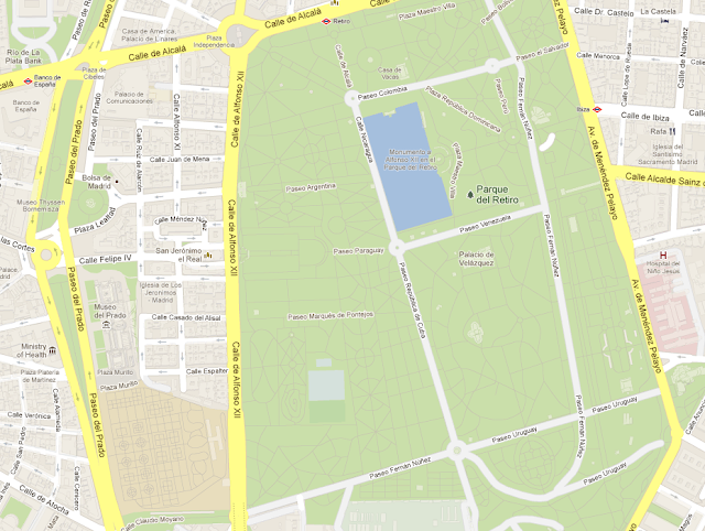
Our new map of Spain, for example, not only shows the famous Museo del Prado and Parque del Retiro in Madrid, but also includes additional building models in surrounding neighborhoods, the well-known “Estanque” (or pond) in the center of the park, and detailed walking paths throughout both the park and the nearby Royal Botanical Gardens.


Explore this area on Google Maps

Of course, the world is always changing, and we want Google Maps to change with it. So when you notice something on the map that needs updating, let us know through the simple “Report a problem” tool in the lower right corner of the map. We’ll make the appropriate changes to the map—often within just a few minutes or hours of reviewing and verifying your feedback! This tool launches today in the 10 places where we’ve updated our maps, and is already available in dozens of other countries around the world.

With today’s release, the maps that we’ve built through our Ground Truth initiative are now available in a total of 40 countries worldwide. To see the progress we’ve made to date, take a look at the image below.


We hope today’s launch of more comprehensive and accurate maps of Europe will help you explore amazing places from Barcelona and Budapest to Bratislava and beyond.

Posted by Brian McClendon, VP Google Maps and Google Earth
Read More
Posted in Andorra, Bulgaria, Estonia, Europe, Gibraltar, Google Maps, googlenew, Hungary, Latvia, Lithuania, Slovakia, Slovenia, Spain | No comments

Monday, 3 December 2012

New Crisis Response map features storm information for Typhoon Pablo (Bopha)

Posted on 16:37 by Unknown

(Cross-posted on The Official Google.org Blog.)

The Google Crisis Response team has assembled a Typhoon Pablo crisis map to help you track the storm’s progress and provide updated emergency information. On the map, you’ll find storm warnings, shelter locations, the latest weather information, and more. The map is available in English, as well as Filipino. You can also find the map embedded on the Filipino government’s Pablo site.


View larger map

You can easily share and embed these maps on your website — just hit the “Share” button at the top of the map to get the HTML code. We’ll continue to update the maps as more information becomes available.

Posted by Steve Hakusa, Software Engineer, Google Crisis Response
Read More
Posted in crisis response | No comments

Better maps in your Android apps!

Posted on 10:43 by Unknown
(Cross posted on Google Geo Developer Blog) 

Today we’re launching an update to the Google Maps Android API, which gives developers the ability to use Google’s comprehensive, accurate and useful maps to build beautiful Android apps. The updated API is easy to use and features vector-based maps that load quickly and enables users to easily navigate 2D and 3D views, and tilt and rotate the map with simple gestures.

With the new version of the Google Maps Android API, developers can utilize Google Maps to its fullest. We’ve incorporated many of the highly-requested features developers want, such as:
  • More dynamic and flexible UI designs for large screen Android devices, such as tablets, using Android Fragments
  • Adding more Google Maps layers in their apps including satellite, hybrid, terrain, traffic and now indoor maps for many major airports and shopping centers
  • The ability to create markers and info windows with less code
Some of our favorite apps already use Google Maps, such as Trulia, Expedia Hotels and FlightTrack. Soon, when you upgrade to the latest version of these apps, you’ll experience the new API and maps as rich as those in Google Maps for Android.


With the latest Google Maps Android API, Trulia Android app users can search for a place to buy or rent in 3D.

To hear from these developers about their apps and migration to the new version of the API, check out the following Google Developers Live video below.


More than 800,000 sites around the world use our mapping APIs to create amazing and useful apps. We hope you enjoy using this new addition to the Google Maps API family and building mapping experiences that were never before possible on a mobile device.

To get started, follow the Google Maps Android API v2 documentation and reach out to the developer community if you have questions on building your app with this API.

Posted by Andrew Foster, Senior Product Manager, Google Maps
Read More
Posted in Android, Developers, Google Maps API | No comments
Newer Posts Older Posts Home
Subscribe to: Posts (Atom)

Popular Posts

  • Take off for the holidays with Google Street View
    Whether it’s touring the canals of Venice , swimming with the seals in the Galapagos or climbing the Burj Khalifa in Dubai, Street View ha...
  • A bird’s eye view of The Queen’s Diamond Jubilee procession
    Following the royal wedding in 2011, the eyes of the world will again be on London as we celebrate the Diamond Jubilee of Queen Elizabeth I...
  • New Maps domains in 11 countries in Middle East & North Africa
    [Cross-posted from the Google Arabia Blog - in Arabic] With the growing numbers of Internet users in the region, we noticed that a huge num...
  • Apply now to be the next Google Maps Trekker
    We’re working to build the very best map of the world, and we’d love your help to do it. Today we’re kicking off a pilot program that enable...
  • See the seafloor like never before on World Oceans Day
    Only a tiny fraction of our oceans have ever been explored. As a matter of fact, we know more about the surfaces of Mars and the Moon than w...
  • Get a better view of natural geography with Google Maps
    When you look at Google Maps, we want you to see the most comprehensive, accurate and easy-to-understand representation of the entire world....
  • Help improve the “blue dot” for people visiting your venue
    When we announced the availability of indoor maps for Android last November , we also introduced Google Maps Floor Plans as a tool for busi...
  • Refocused Design Evolution, Continued
    In June we launched the start of a comprehensive visual redesign for Google Maps founded on three key principles: focus, elasticity, and ef...
  • Google Map Maker now available in South Africa and Egypt, and coming soon to more corners of the globe
    From the wild grasslands of Kruger National Park to the the extraordinary pyramids of Giza, the world is ripe with wonders waiting to be exp...
  • Visit the Hiroshima Peace Memorial in Street View
    We’ve added many historic sites to Street View to let you explore these places online, and now we’ve included Street View imagery of the Hir...

Categories

  • #treasuremap
  • +1
  • 3D
  • 8bitmaps
  • Adwords Express
  • Africa
  • Amazon
  • Andorra
  • Android
  • api
  • Art Project
  • Audi
  • biking
  • Boost
  • Boulder
  • Brazil
  • Bulgaria
  • Business Photos
  • Canada
  • check-in
  • community
  • competition
  • contest
  • crisis response
  • Culture
  • custom maps
  • developer
  • Developers
  • directions
  • disaster response
  • discovery
  • Download Free Nokia 6680 PC Suite
  • Download Micromax pc suite
  • Download Micromax pc suite for window
  • Download micromax Q5 Pc suite
  • Download PC suite
  • Download Samsung Mobile Pc Suite
  • earth outreach
  • education
  • Enterprise
  • Estonia
  • Europe
  • Fusion Tables
  • galaxy s2
  • Gibraltar
  • GMM
  • google
  • Google Earth
  • Google Earth Engine
  • Google Map Maker
  • Google Maps
  • Google Maps API
  • Google Maps Engine
  • Google Maps for Mobile
  • Google Maps Navigation
  • Google Maps Transit
  • Google Places
  • Google Plus
  • Google Search
  • Google Street View
  • google.org
  • Google+
  • googlenew
  • Grand Canyon
  • ground truth
  • Halloween
  • historical
  • history
  • Hotpot
  • HTC PC Suite Download
  • HTC PC suite for WIN 7
  • HTC PC Suite Free Download
  • HTC sync Downlaod
  • HTC Sync Download for windows
  • HTC Sync Free Download
  • Hungary
  • imager
  • imagery
  • Indoor Maps
  • iPhone
  • Iraq
  • Japan
  • Latitude
  • Latvia
  • layers
  • LG Mobile PC Suite
  • LG Mobile Support Tool
  • LG PC suite Download
  • Lithuania
  • London
  • Malaysia
  • Mall of America
  • Map Maker
  • mapsgl
  • Matt Harding
  • Mexico
  • Micromax A110
  • Micromax Canvas 2
  • Micromax pc suite download
  • Micromax PC suite for windows
  • Micromax Q5 FB PC Suite Free Download
  • Micromax Q5 FB PC Suite Free Download For Windows
  • Mircromax Q3 PC Suite Download for windows
  • Mobile
  • Monticello
  • My Maps
  • my places
  • my tracks
  • navigation
  • new Google Maps
  • Nokia 5250 PC Suite Free Download
  • Nokia 5530 PC Suite Free Download
  • Nokia 5610 PC Suite Free Download
  • Nokia 5800 PC Suite Free Download
  • Nokia 6030 PC Suite Free Download
  • Nokia 6680 PC Suite Download for windows
  • Nokia 6680 PC suite free Download
  • Nokia Asha 305
  • Nokia Asha 306 PC Suite download
  • Nokia C3-01
  • Nokia Free Suite
  • Nokia Mobile PC suite Download
  • oblique imagery
  • ocean
  • offline maps
  • Outreach
  • Pakistan
  • Panoramio
  • Parks Canada
  • Pegman
  • photo tours
  • photos
  • picasa
  • Quiz
  • real estate
  • Russia
  • Samsung C3322 PC Suite Free Download
  • Samsung C6712 PC Suite Free Download
  • Samsung Corby 2 PC Suite Free Download
  • Samsung Galaxy
  • Samsung Galaxy 5830 PC Suite Download
  • Samsung Galaxy Ace Hugo Boss
  • Samsung Galaxy Ace PC Suite Download
  • Samsung galaxy I8190 S III PC Suite Download
  • samsung galaxy mega
  • Samsung Galaxy Mega 5.8
  • Samsung Galaxy Mega 6.3
  • samsung galaxy s2
  • Samsung Galaxy Stratosphere II I415
  • samsung GT-I9100 pc suite
  • Samsung GT-S6102 Galaxy Y Duos PC Suite Download
  • Samsung GT-S6102 PC Suite Download
  • Samsung I9000 Galaxy S PC Suite Download
  • Samsung mobile pc suite downlaod
  • samsung mobile pc suite download for Windows 7 ad XP
  • samsung mobile pc suite download for Windows 7 and XP
  • Samsung N7100
  • Samsung Note 2
  • Samsung Note II
  • Samsung PC Suite Download.
  • Samsung Wave Y Drivers Download
  • Samsung Wave Y PC Suite Free Download
  • Santa
  • Santa Tracker
  • search stories
  • SketchUp
  • Slovakia
  • Slovenia
  • Sony PC Companion Free Download
  • Sony PC Suite Free Download
  • South Sudan
  • space
  • Spain
  • sports
  • Street View
  • Sumsang C3322 Drivers Download
  • SXSW
  • Tags
  • Thomas Jefferson
  • Thomas Jefferson Foundation
  • Tip of the week
  • tour guide
  • traffic
  • Train
  • Transit
  • trees
  • Trekker
  • U.S. National Park Service
  • Ukraine
  • University of Virginia
  • voice search
  • walking
  • Waze
  • weather
  • webgl
  • Xperia PC Suite Download
  • zagat

Blog Archive

  • ►  2013 (87)
    • ►  November (7)
    • ►  October (3)
    • ►  September (4)
    • ►  August (9)
    • ►  July (13)
    • ►  June (12)
    • ►  May (10)
    • ►  April (9)
    • ►  March (11)
    • ►  February (2)
    • ►  January (7)
  • ▼  2012 (192)
    • ▼  December (9)
      • Follow Santa live on Google Santa Tracker
      • Tips for getting the most from Google Maps on iPhone
      • Count down to Christmas Eve with Google Santa Tracker
      • Google Maps is now available for iPhone
      • Google Maps: You learn, we listen
      • Explore digital archives of buildings in Japan aff...
      • Building a better map of Europe
      • New Crisis Response map features storm information...
      • Better maps in your Android apps!
    • ►  November (5)
    • ►  October (24)
    • ►  September (13)
    • ►  August (15)
    • ►  July (18)
    • ►  June (21)
    • ►  May (17)
    • ►  April (19)
    • ►  March (26)
    • ►  February (12)
    • ►  January (13)
  • ►  2011 (234)
    • ►  December (13)
    • ►  November (17)
    • ►  October (19)
    • ►  September (15)
    • ►  August (23)
    • ►  July (25)
    • ►  June (20)
    • ►  May (20)
    • ►  April (23)
    • ►  March (24)
    • ►  February (18)
    • ►  January (17)
  • ►  2010 (21)
    • ►  December (21)
Powered by Blogger.

About Me

Unknown
View my complete profile