Your Mobile Support

  • Subscribe to our RSS feed.
  • Twitter
  • StumbleUpon
  • Reddit
  • Facebook
  • Digg

Tuesday, 31 July 2012

Calling all Aussie Mappers! Google Map Maker is now available in Australia

Posted on 20:00 by Unknown

G’day mappers — at last it’s time to share the treasures of the Great Southern Land. Today, Google Map Maker opens its maps to Australia, so you can add your local knowledge to Google Maps for all the world to see.


Help share Australia’s natural gems with tourists and locals alike by drawing the hiking trails through the Eucalypt forests of Tasmania or adding all the campsites surrounding Uluru-Kata Tjuta National Park. Then, once you’re ready for some rest and relaxation, why not map the beach resorts of Kangaroo Island, all the best restaurants along the Coral Sea of Queensland, or your favourite billabong for a day of fishing? You can even add your neighbourhood rugby club before heading off to a game.

Once approved your contributions will appear on Google Maps, Google Earth and Google Maps for mobile, accurately reflecting your real-life neighbourhood. You can even join with other local mappers and use your local expertise to review one another’s contributions to the map. To see examples of what people all around the world are adding in Map Maker, you can watch mapping in real-time.

Hyams Beach comes alive with Google Map Maker.

Google Map Maker warmly welcomes the people of Australia to the team of citizen cartographers from 200 countries and regions across the globe as they continue to build the world map. To learn more, subscribe to the Map Maker YouTube Channel, and get started mapping today!

Posted by Nilesh Tathawadekar, Software Engineer
Read More
Posted in Google Earth, Google Maps, Map Maker | No comments

At your service: planned NYC subway changes now in Google Maps

Posted on 05:00 by Unknown

Since first making New York City public transit directions available in Google Maps, we’ve been working to deliver you with the most accurate and useful information about subway, bus, commuter rail, and ferry service across the greater metro area. Starting today, we’ll also be showing planned service alerts for the city’s subways, which serve more than 1 billion riders each year.

Have you ever arrived at a subway platform only to find that the train you intended to take is skipping stops, rerouted on another line, or isn't running at all due to scheduled maintenance? Now when you click on any of the 468 New York City subway stations labeled on Google Maps, you’ll see whether any planned service changes are expected to affect that station at the time. In addition, the relevant alerts will be included in the step-by-step transit directions pointing you wherever you’re going.


Get transit service alerts on your desktop browser

If you’re looking to find the best route to see a concert after work or checking for any expected delays when already running late, this feature works when you’re online via maps.google.com and Google Maps for Mobile on Android. To adjust your travel around the alerts you see, simply choose another suggested route or change your departure time.


Get transit service alerts on Google Maps for Android

We’re regularly adding new cities and features globally and looking forward to continuing our efforts to make travel by public transportation a better experience in more than 400 regions around the world. For everybody who lives in one of New York City’s five boroughs, commutes in and out every day or is visiting for business or vacation, we hope today’s update improves the ease and efficiency of your trips around the city.

Posted by Csaba Garay, Transit Partner Technology Manager, Google Maps
Read More
Posted in Android, directions, Google Maps, Transit | No comments

Monday, 30 July 2012

Take a virtual walk in Downing Street

Posted on 01:00 by Unknown

Following in the footsteps of The White House, we’re delighted to announce the iconic residence of the UK Prime Minister and Chancellor of the Exchequer, Downing Street, London, can now be seen in Street View. Google Maps users can take a virtual stroll along the street and stand in front of the famous front door to No.10, right at the heart of government.

View Larger Map

As an added bonus, we were lucky enough to capture Larry, the Downing Street cat, relaxing in his favourite spot on the front porch. Since February 2011, Larry has held the official position of Chief Mouser to the Cabinet Office.

To learn more about Street View, visit our website.

Posted by Razia Ahamed, Geo Partnerships Manager, Google
Read More
Posted in Google Maps, imagery, Street View | No comments

Friday, 27 July 2012

Imagery Update: Explore your favorite places in high-resolution

Posted on 10:00 by Unknown

In our continuing effort to build the most comprehensive and accurate view of the world, the Google Earth and Maps Imagery team just published another extensive catalog of new imagery. This week we have exciting new updates to both our high resolution aerial and satellite imagery and our 45° imagery.

New high resolution aerial and satellite imagery:
This week we published new high resolution aerial and satellite imagery for 25 cities and 72 countries/regions. Our updates are now available in both Google Earth and Maps. We’ve highlighted a couple interesting locations below:

Olympic Park and Village, Stratford, London, United Kingdom

We’ll start in the United Kingdom, where the London 2012 Olympic Games opens this Friday. We’ve released new satellite imagery taken this past May of the Olympic Park and Village. In the image above, you can see the final construction touches being added to the open-air Olympic Stadium (lower right).

Perspective view of Bryce Canyon, Utah

Even if you aren’t a geologist, you’ll enjoy exploring the new imagery for Bryce Canyon, Utah - famous for its text-book example of hoodoos. The image above is a perspective view of aerial imagery taken in June.

New 45° imagery available for 28 cities:
This week our 45° imagery update includes coverage for 21 U.S. cities and 7 international locations. Below are some great examples from Munich, Germany, and Chicago, Illinois:

The Frauenkirche, a symbol of the Bavarian capital city - Munich, Germany

With approximately 1.4 million inhabitants, Munich is the capital of Bavaria and the third largest city in Germany. The image above shows the Frauenkirche, a symbol of the Bavarian capital city.

The Trump International Hotel and Tower - Chicago, Illinois

Chicago is a an industrial metropolitan city with an impressive skyline that really stands out with our new 45° imagery. The image above features the Trump International Hotel and Tower, the second-tallest building in the United States and a prominent Chicago landmark.

Cities with new high resolution 45° imagery:
United States: Anderson, CA; Beech Island - New Ellenton, GA; Cape Girardeau, MO; Carthage, MO; Chicago, IL; Clarksville (outskirts), TN; Columbus - Reynoldsburg, OH; Dayton, OH; Everett, WA; Galena, KS; Idaho Falls, ID; Joplin, MO; Lafayette (outskirts), LA; Lancaster, CA; Louisville, KY; Lowell, MA - Nashua, NH; Pittsburgh, PA; Pueblo (outskirts), CO; Redding, CA; Springfield, IL; Yuba City, CA.
International: Birmingham, UK; Catania, Italy; Denia, Spain; parts of London, United Kingdom; Meyrin - Vernier, Switzerland; Munich, Germany; Neuchatel, Switzerland.

Areas with new high resolution aerial imagery:
United States: Antelope Wells NM; Bryce Canyon UT; Green Bay WI; Huron, SD; Hutchinson, KS; Olympia WA; Park Hills, MO; Peach Springs, AZ; Phoenix, AZ; Placerville, CA; Riverside, CA; Rosenfeld, TX; Waverly, OH.
International: Wiener Neustadt, Austria; Alicante, Spain; Denia, Spain; Gandia, Spain; Las Rozas, Spain; Lugo, Spain; Santander, Spain; Sueca, Spain; Vitoria, Spain; Bern, Switzerland; Geneva, Switzerland; Nyon, Switzerland.

Countries/regions with new high resolution satellite updates:
Argentina, Australia, Austria, Belarus, Botswana, Brazil, Bulgaria, Burkina Faso, Canada, Cape Verde, Chile, China, Colombia, Croatia, Cuba, Cyprus, Djibouti, Dominican Republic, Egypt, Eritrea, Estonia, Ethiopia, France, Greece, Greenland, Guinea-Bissau, Guyana, Haiti, Honduras, Hungary, India, Indonesia, Iran, Italy, Jamaica, Latvia, Lesotho, Libya, Lithuania, Madagascar, Mauritania, Mexico, Morocco, Namibia, Nepal, New Zealand, Nicaragua, Pakistan, Papua New Guinea, Paraguay, Peru, Poland, Romania, Russia, Saudi Arabia, Serbia, Slovakia, Slovenia, South Africa, Spain, Switzerland, Tunisia, Turkey, Ukraine, United Kingdom, United States, Uruguay, Venezuela, Western Sahara, Yemen, Zambia, Zimbabwe

If you’d like to receive an email notification for the latest Google Earth and Maps Imagery team updates for your favorite areas, we’ve got just the tool: our Follow Your World application. Happy exploring!

Posted by Bernd Steinert, Geo Data Specialist
Read More
Posted in Google Earth, Google Maps, imagery, oblique imagery | No comments

Thursday, 26 July 2012

A more accurate starting point in Google Maps

Posted on 16:46 by Unknown

Maps users have told us that when they embark on a journey, they often want to start from their current location. That’s why today we’re making Google Maps more useful by automatically zooming into your city as the starting point for your search. Now you can dive right in and discover the local businesses, restaurants and attractions near you, without having to manually enter your location. Much easier and faster.

We show the details of your starting point in the left panel. And if for some reason your starting point isn’t correct you can easily add your street address, zip code, city and state, or country by clicking on the Correct it link.

Location information displayed on left with option to correct it.

For those of you who’ve already set a Default Location with Google Maps, we hope you’ll appreciate this smart new feature that we hope will make Google Maps easier to use for your next adventure.

Posted by Andrey Salaev, Software Engineer, Google Maps
Read More
Posted in Google Maps | No comments

3D imagery now available on iPad and iPhone

Posted on 08:52 by Unknown

Today, we’re happy to announce the availability of 3D imagery for Google Earth on the new iPad, iPad 2 and iPhone 4S.

A map must be comprehensive and accurate no matter where you are or what device you use. We also believe maps can be useful in ways you might not have imagined. With today’s release of Google Earth for iOS you can literally fly through breathtaking 3D city landscapes and images and follow virtual tours of places you’ve never been -- all with a simple swipe of your fingertip. It’s a new, and I think magical way to explore the world in which we live.

The growing list of 3D cities include Boulder, Boston, Charlotte, Lawrence (Kan.), Long Beach (Ca.), Los Angeles, Portland (Ore.), San Diego, Santa Cruz, Tampa, Tucson, and the San Francisco Bay Area (including the Peninsula and East Bay) as well as Rome, Italy. We’ll keep building and releasing 3D imagery for new locations as fast as we can and by the end of the year we aim to have coverage for metropolitan areas with a combined population of 300 million people.


Also new in this release is a “tour guide” to show you interesting places to explore. We’ve put together short tours of thousands of famous places and historical sites across the globe so it’s easier than ever to discover amazing places. Just pull up the tab at the bottom of the screen to open the tour guide. Each image highlights a tours or place of interest in the area you are looking. Click on an item and you will be flown there. As you fly in and around the sites, snippets from Wikipedia provide additional information about the location. It’s like having a local expert right beside you! The tour guide is available for all iOS devices running iOS 4.2 and newer.

To start exploring, download the latest version of Google Earth for iPhone, iPad, and iPod touch from the Apple App Store today.

Posted by Peter Birch, Google Earth Product Manager
Read More
Posted in 3D, Google Earth, imagery, Mobile | No comments

Monday, 23 July 2012

Forty years of our planet, from space

Posted on 09:09 by Unknown

Today we celebrate the 40th anniversary of the Landsat satellite program -- now the longest-running continuous acquisition of satellite images of the Earth's surface. Over the years, Landsat has collected petabytes of images offering an historic perspective on planetary change that can help scientists, independent researchers, and nations make informed economic and environmental policy decisions.

We’re working with the USGS and Carnegie Mellon University, to make parts of this enormous collection of imagery available to the public in timelapse videos of the Earth's surface. With them you can travel through time, from 1999-2011, to see the transformation of our planet. Whether it’s deforestation in the Amazon, urban growth in Las Vegas or the difference in snow coverage between the seasons. Here are a few highlights.

Landsat timelapse tour of the Amazon rainforest shows the spread of deforestation between 1999 (left) and 2011 (right).

The rapid growth of Las Vegas, Nevada between 1999 (left) and 2011 (right) is visible in the Landsat timelapse tour.

A seasonal timelapse created using MODIS imagery, where every video frame represents about one week. This shows snow-cover differences over the U.S. between February and August, 2002.

We believe these may be the largest video frames ever created. If you could see the entire video at full resolution, a single frame would be 1.78 terapixels which is 18 football fields' worth of computer screens laid side-by-side.

In 2008, the USGS opened access to the entire Landsat archive for free. Google Earth Engine makes it possible for this data to be accessed and used by scientists and others no matter where they are in the world. Watch the video below to learn more about the history of the Landsat program and how Google Earth Engine was used to process and analyze this enormous archive of planetary imagery.


Happy 40th, Landsat! We're proud to be making this vast archive available to the public, and to be enabling deep analysis of this data by scientists and policymakers all over the world. Head over to the Google Earth Engine site to experience all the fully interactive tours of these timelapse videos.

Posted by Eric Nguyen, Software Engineer for Earth Engine and Randy Sargent, Visiting Researcher from Carnegie Mellon University
Read More
Posted in Google Earth, Google Earth Engine, imagery | No comments

Friday, 20 July 2012

A Hawkes eye view in Google Earth

Posted on 01:00 by Unknown

While some children spend their youth fascinated by model cars and legos, I was always more interested in aerial photography. For years I amassed a collection of books capturing this unique perspective of the world, and it was obvious from looking through my personal library that British aerial photographer Jason Hawkes was a huge influence and hero of mine. Last year, Jason came to the Google office in London to give a Tech Talk, and I was finally able to meet him in person. He mentioned being a big fan of Google Earth, using it to put together virtual flight plans for his trips.

After Jason’s visit, we decided to collaborate on an effort to bring geographic context to his work with Google Earth. By creating a KML file showcasing some of his most beautiful images, we were able to truly capture a “Hawkes eye view” of locations all around the world.

The English coastline, near Sittingbourne, Kent captured by Jason Hawkes

While Jason hails from the United Kingdom, his work spans the globe. Simply open the KML in Google Earth, and you’ll feel like you’ve taken a seat right next to him as he flies over the United Kingdom, New York, Las Vegas, Hong Kong, Budapest and Minorca.

The Great Sphinx at Luxor in Las Vegas, Nevada

Given the excitement around London this summer, we included a variety of photographs that bring the changing face of the city to life, from the addition of The Shard skyscraper to the massive redevelopment taking place in Stratford for the Olympic games.

The Shard and River Thames in London, England

The Olympic Park in London, England

When viewing the KML in Google Earth, make sure the “3D Buildings” layer is enabled in the left hand panel to enjoy a 3D experience of famous buildings. Happy flying!

Posted by Phil Verney, Program Manager, Google Earth and Maps
Read More
Posted in Google Earth, imagery, London, photos | No comments

Thursday, 19 July 2012

Maps for good: Google Earth Outreach Developer Grants 2012

Posted on 09:26 by Unknown

In 2011, the Google Earth Outreach team awarded a first round of Developer Grants to organizations with outstanding mapping ideas. These grants support the technical development of maps and enable nonprofits to implement cutting-edge mapping technology to make an impact on the world.

This year at Google I/O, we announced the 2012 Google Earth Outreach Developer Grants program in a session called “Maps for Good.” We were honored to have two developers speaking on behalf of organizations who were awarded a Developer Grant in 2011, including Jake Wall from Save the Elephants and Kevin Bluer from AXS Map. Learn more about their projects, as well as other 2011 grantee work for inspiration on how mapping could bring your nonprofit’s work to life.

Over the past few months, we’ve seen more nonprofits making use of tools like Google Maps Engine and developing applications on Android devices. We expect to see project proposals with innovative ideas that address the world’s most pressing problems in the areas of the environment, humanitarian issues, disaster preparedness, at both the local and global level.


Be inspired by how mapping can help spread your nonprofit’s message

Visit the Google Earth Outreach website to learn more about this year’s Developer Grants program and make sure your organization is in an eligible country. The deadline to apply with your initial project proposal is August 1, 2012 at 11:59pm PST.

Good luck to all of this year’s applicants!

Posted by Tanya Birch, Google Earth Outreach team
Read More
Posted in developer, Google Earth, Outreach | No comments

More detailed maps in parts of Europe, Africa and Asia

Posted on 03:30 by Unknown
[Cross-posted from the Official Google Blog]

Whether you’re travelling abroad or exploring your own city, the maps you carry with you should be comprehensive, accurate and easy to use. We're constantly making improvements to Google Maps to help you find and discover places that are meaningful to you no matter where you are. And today, we’re launching updated maps of Croatia, Czech Republic, Greece, Ireland, Italy, Lesotho, Macau, Portugal, San Marino, Singapore and Vatican City to do just that.

As was the case for past updates, our new maps are more detailed and precise. For example, in Ireland we now have excellent coverage of National Heritage Areas, as well as more detailed coastlines and bodies of water:

Explore this area in Google Maps

We’ve also added more accurate names and locations for major points of interest, such as airports, universities and public squares. Here you can see St. Mark’s Square in Venice, now with accurately aligned canals, 3D buildings and detailed labels of the countless number of places to be discovered.

Explore this area on Google Maps

We’ve also added better and more clearly labelled ferry routes in many places, such as the area below surrounding Naples, Italy. Traveling by ferry is one of my favorite ways to explore a city—I love looking back from the water at the cityscapes—and this improvement will help you find the ferry routes you need to do the same. You can even use Google Maps to get transit-based directions for ferries. We take into account ferry timetables to route you over water just easily as you might follow our driving directions over land.

Explore this area on Google Maps

In addition to the above changes, local roads on these maps are now more accurately distinguished from highways, and multi-lingual names are available for a larger proportion of roads in many of the updated countries. These improvements give you a better visual feel of the location, as well as make it easier to navigate the area when you're on the ground.

Of course, the world around us is always changing, so we’re making our “Report a problem” tool available in each of these countries as well. You can use it to send us a description of any corrections to be made, which we then incorporate into our maps, often within days.

Today’s improvements follow the recent expansion of our collection of Antarctic imagery, and are part of our ongoing effort to build maps that are comprehensive, accurate and easy to use. We've partnered with numerous authoritative sources to ensure that Google Maps is a living reflection of every corner of the globe. After all, a map is only as good as the data behind it. The maps that we've built will help ensure that you get correct and up-to-date information about the world around you.

Update 8:00pm: We're also making certain maps of the 11 countries listed above, plus Egypt, Poland and Ukraine, available offline in Google Maps for Android.

Posted by Michael Weiss-Malik, Engineering Manager, Google Maps
Read More
Posted in Google Maps | No comments

Tuesday, 17 July 2012

Become an Antarctic explorer with panoramic imagery

Posted on 00:00 by Unknown
(Cross posted to the Official Google Blog) 

In the winter of 1913, a British newspaper ran an advertisement to promote the latest imperial expedition to Antarctica, apparently placed by polar explorer Ernest Shackleton. It read, "Men wanted for hazardous journey. Low wages, bitter cold, long hours of complete darkness. Safe return doubtful. Honour and recognition in event of success." While the ad appears apocryphal, the dangerous nature of the journey to the South Pole is certainly not—as explorers like Roald Amundsen, Robert Falcon Scott and Shackleton himself discovered as they tried to become the first men to reach it.

Back in September 2010, we launched the first Street View imagery of the Antarctic, enabling people from more habitable lands to see penguins in Antarctica for the first time. Today we’re bringing you additional panoramic imagery of historic Antarctic locations that you can view from the comfort of your homes. We’ll be posting this special collection to our World Wonders site, where you can learn more about the history of South Pole exploration.


With the help of the Polar Geospatial Center at the University of Minnesota and the New Zealand Antarctic Heritage Trust, we’ve added 360-imagery of many important spots, inside and out, such as the South Pole Telescope, Shackleton's hut, Scott’s hut, Cape Royds Adélie Penguin Rookery and the Ceremonial South Pole.


The ceremonial South Pole - View Larger Map


The interior of Shackleton’s Hut demonstrates the host of supplies used in early 20th century Antarctic expeditions—everything from medicine and food to candles and cargo sleds can be found neatly stored inside. (View Larger Map)

With this technology, you can go inside places like Shackleton’s Hut (pictured above) and the other small wooden buildings that served as bases from which the explorers launched their expeditions. They were built to withstand the drastic weather conditions only for the few short years that the explorers inhabited them, but remarkably, after more than a century, the structures are still intact, along with well-preserved examples of the food, medicine, survival gear and equipment used during the expeditions. Now anyone can explore these huts and get insight into how these men lived for months at a time.


The landscape outside of Robert Falcon Scott’s supply hut conveys just how desolate the area is. For these early explorers, the supply huts were an oasis of warmth and comfort in a cold and inhospitable landscape. (View Larger Map)

This new imagery was collected with a lightweight tripod camera with a fisheye lens—equipment typically used to capture business interiors through the Business Photos program. We worked with this technology because of its portability, reliability and ease-of-use (our Street View trikes wouldn’t be much use in the snow).

The goal of these efforts is to provide scientists and travel (or penguin) enthusiasts all over the world with the most accurate, high-resolution data of these important historic locations. With this access, schoolchildren as far as Bangalore can count penguin colonies on Snow Hill Island, and geologists in Georgia can trace sedimentary layers in the Dry Valleys from the comfort of their desks. Feel free to leave your boots and mittens behind, and embark on a trip to Antarctica.


Posted by Alex Starns, Technical Program Manager, Street View
Read More
Posted in Business Photos, Google Maps, Street View | No comments

Friday, 13 July 2012

My Tracks 2.0

Posted on 07:45 by Unknown

Back in 2009 we released My Tracks, an Android app that uses your phone’s GPS capabilities to visualize your location over time for sharing in Google Maps and Google Earth.

We’ve used My Tracks to follow team HTC-Columbia during the Tour de France and trace the paths of our skiing adventures. A year after launch we open sourced the software and released the code to the world for developers to use in their own applications. Now, we’re happy to announce that My Tracks 2.0 is available for download on Google Play.

Trace your path with My Tracks 2.0

My Tracks 2.0 comes with a variety of new features, including:
  • The ability to play back your tour directly on Google Earth for Android
  • Aggregation of statistics over time to show trends in your performance
  • Simpler, faster user interface
  • Improved charts and stats tables that are easier to read
Update to My Tracks 2.0 today and start tracing and sharing your path around the world.

Posted by Jimmy Shih, Software Engineer for My Tracks
Read More
Posted in Google Earth, Google Maps, Mobile, my tracks | No comments

Thursday, 12 July 2012

Street View goes on a road trip through California's national parks

Posted on 10:03 by Unknown
[Cross-posted from the Official Google Blog]

One hot summer day in Yosemite National Park in Northern California, I sat under a tree along a lazy river in awe of the natural beauty around me. I looked out at the majestic granite mountains, the chirping birds and the rustling leaves, and thought about how they were the same that day as they had been thousands of years ago.


View Larger Map

People around the world can now appreciate the beauty and timelessness of the wilderness through Street View. We've recently added 360-degree panoramic imagery for five of California’s national parks—including Yosemite—to Google Maps. In addition, we've refreshed Street View imagery across most of the state. You can now take a virtual road trip practically the entire stretch of California from north to south.

Redwood National Park sits near the California-Oregon border and hugs the Pacific Ocean. It’s most famous for its giant redwood trees—the tallest trees on Earth. With Street View, you can now stare up at them without straining your neck:


View Larger Map

Moving inland to Yosemite National Park, we visit historic Inspiration Point, the site famously photographed by Ansel Adams in “Clearing Winter Storm”. Panning right from the same vantage point, you can see the cliffs of El Capitan and the picturesque Bridalveil Fall waterfall flanking iconic Half Dome, a granite rock formation almost 5,000 feet tall. You can also use Street View to venture into the valley, overlook Glacier Point (visited by John Muir and President Theodore Roosevelt in 1903), explore the more remote upcountry along Tioga Pass road and see the Giant Sequoias in Mariposa Grove.


View Larger Map

You’ve seen the redwoods, now see more enormous trees with a visit to Sequoia & Kings Canyon National Parks, whose namesake trees are the most massive in the world. It would take almost 30 adults linking their outstretched arms to wrap all the way around the largest sequoias. These parks also offer rich and varied landscapes featuring everything from mountains to canyons to caverns.


View Larger Map

The name may be foreboding, but Death Valley National Park, which lies along the California-Nevada border and has the lowest elevation of any spot in North America, is home to a variety of flora and fauna and well worth a visit. With average summer temperatures in this desert environment soaring above 110 degrees Fahrenheit, most people visit in the winter, but Street View lets you check it out any time of year—no sunblock required.


View Larger Map

Slightly north of the U.S.-Mexico border is the fifth and final national park recently added to Street View: Joshua Tree National Park. The gnarly, twisted trees here seem like something straight out of a Dr. Seuss book. Plan your escapades ahead of time from your browser, then pack up your hiking shoes or your mountain bike and hit the trails in this one-of-a-kind desert landscape.


View Larger Map

This only scratches the surface of what California parks have to offer travelers looking to explore the great outdoors. We hope a virtual trip through Street View inspires you to visit these places in person as well. If you need some additional inspiration, I’ll leave you with a quote from naturalist and author John Muir:
Climb the mountains and get their good tidings. Nature's peace will flow into you as sunshine flows into trees. The winds will blow their own freshness into you, and the storms their energy, while cares will drop away from you like the leaves of Autumn.


View Larger Map

Driving down Highway 1 through Big Sur is the ultimate road trip in California.


Posted by Evan Rapoport, Street View Product Manager
Read More
Posted in Google Maps, Street View | No comments

Wednesday, 11 July 2012

Google Maps for Africa gets better - walking directions launched!

Posted on 12:00 by Unknown
(Cross Posted from Google Africa Blog)

In 2010, we announced the availability of driving directions on Google Maps in many African countries. This is a feature that allows users to get driving direction information from one location to another (e.g from Kotoka International Airport to Hotel Novotel in Victoria Borg, Accra in Ghana)

But of course not everyone drives or always needs to drive, so today we’re bringing walking directions for 44 African countries!


To get walking directions, start by doing one of the following:

  1. Click Get directions, enter a starting and ending location and click Get Directions.
  2. In the search field, enter a from-to statement (example: from Nyayo House to Anniversary Towers) and click Search Maps.
  3. Click "Directions" in an info window that pops up for a business or location
  4. Right-click on the map to get directions to that location


Click on the “walking” icon at the top


Walking directions are also available on Google Maps for Mobile.


Try out the walking directions today. As a reminder, walking directions are currently in beta, and we recommend that you use caution, as the routes may be missing sidewalks or pedestrian crossings. Walking directions are editable, so if anything is amiss, you can correct it with our community mapping tool Google Map Maker. Google Map Maker is a tool that allows you to add and update geographic information for millions of users to see in Google Maps and Google Earth.

We are always grateful to our active African online cartographers who have helped make our African maps what they are today.

We hope you enjoy using walking directions on Google Maps!

Posted by Jacqueline Rajuai, GIS Specialist and Jarda Bengl, Business Product Manager, Google
Read More
Posted in Africa, Google Maps, walking | No comments

Biking directions expands into Europe and Australia

Posted on 09:00 by Unknown

Back in 2010 we added biking directions for users of Google Maps in the US and Canada. Helping cyclists navigate the bike trails throughout those countries proved hugely popular, so we’re wheelie excited to announce that starting today, we've also added extensive biking data to Google Maps for Austria, Australia, Belgium, Denmark, Finland, France, Germany, Liechtenstein, Luxembourg, Monaco, Netherlands, Norway, Sweden, Switzerland and the United Kingdom. In many of these countries we are also enabling biking directions in beta mode.

We know how popular cycling is in many parts of the world, so we wanted to include as much bike trail data as possible to provide efficient routes, allow riders to customize their trips, make use of bike lanes, calculate rider-friendly routes that avoid big hills and busy roads and to customize the look of the cycling map to encourage people to hop on their bikes. So that's exactly what we've done.

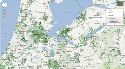
To start off, we've added information about bike trails, lanes and recommended roads directly to the map through the updated biking directions legend. This can help you get a better sense of your route, or easily find trails nearby for a recreational ride. When you're zoomed into a city, use the widget at the top right of the map to turn on the "Bicycling” layer.


Cycling is big in the Netherlands!

If you’re keen to start riding into work, or maybe just do your bit for the environment by swapping your car for a bike a couple of days a week, biking directions can help you find a convenient route that makes use of dedicated bike lanes and avoids hills whenever possible.

To use biking directions, select the cyclist icon from the list of routing modes when you search for directions. Watch this short video for more information. Biking directions are now available in Austria, Australia, Belgium, Denmark, Finland, Netherlands, Norway, Sweden, Switzerland and the United Kingdom.


A three hour ride through Swedish countryside

We’ve been working hard to add as much biking data to our maps as possible and we hope you enjoy this latest addition to Google Maps. That said, knowing the best roads for cycling is a challenge and there is only one group of people in the world who really know where the best cycle paths are in their regions: Cyclists!

Luckily, Google Map Maker is available in most countries where we’re releasing biking data and directions today, so we encourage all of you to help your fellow riders enjoy cycling as much as you do. Check out the brief tutorial and start adding those bike paths to your city or other places with which you’re familiar!


Add and edit bike data in Google Map Maker

If you live in a country that does not yet have Map Maker enabled, we appreciate your patience while we work to make it available as soon as possible. Or if you live in a place where biking directions are not yet enabled, but where you can already contribute to the map via Map Maker, we encourage you to add biking information in the meantime - and thanks for your help in making life easier for riders in as many countries as possible!

Posted by Kai Hansen, Product Manager, Google Maps
Read More
Posted in Android, biking, Google Maps | No comments

Tuesday, 10 July 2012

Indoor Google Maps help you make your way through museums

Posted on 09:01 by Unknown
(Cross posted to Official Google Blog) 

In the past, navigating through museums could be an art form in and of itself. But Google Maps for Android has got wayfinding inside your favorite museums down to a science. With indoor maps and walking directions for U.S. museums now available on your Android phone or tablet, you can plan your route from exhibit to exhibit, identifying points of interest along the way, including between floors.

Today, we’ve added more than twenty popular U.S. museums to our collection of over 10,000 indoor maps that we launched in November: the de Young Museum in San Francisco, the Philadelphia Museum of Art, Cincinnati Museum Center, the Indianapolis Museum of Art, the American Museum of Natural History and 17 Smithsonian museums—plus a zoo!

My location in the American Museum of Natural History, New York City

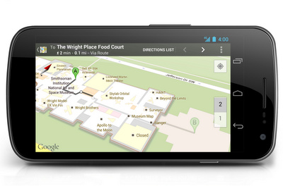
To access the floor plans, simply open Google Maps on your Android phone or tablet and zoom in on the museum of interest. To find the museum, either search for it by name using the magnifying glass icon or, if you’re already there, use the “My location” feature to orient yourself. With the “My location” feature enabled you can even get indoor walking directions.

Indoor walking directions in the National Air and Space Museum - Smithsonian Institution, Washington, D.C.

More museums are adding their floor plans to Google Maps for Android soon, including the SFMOMA, The Phillips Collection, the Nelson-Atkins Museum of Art and the National WWII Museum in New Orleans. If you’re interested in getting your museum’s floor plan included in Google Maps, visit the Google Maps Floor Plans tool.

Along with the Google Art Project, indoor mapping is one more way we’re working with museums to bring greater access to revered cultural and educational institutions around the world. Tap into the latest version of Google Maps for Android in Google Play, and enjoy exploring the art and science of the great indoors.

Posted by Cedric Dupont, Google Maps for Mobile team
Read More
Posted in Android, Google Maps, Indoor Maps | No comments

Tuesday, 3 July 2012

Inside Map Makerpedia

Posted on 13:45 by Unknown

Less than a year ago, we launched the Map Makerpedia to bring together the collective knowledge and expertise of the Map Maker community into a Wiki-style guide. We recently rolled out an update to the site, which includes a more intuitive layout and revised templates.


We’re thrilled to share these updates and a brief overview of the developments we’ve made over the past few months that have made it an invaluable resource for mappers across the globe.

Map Makerpedia is now divided into three broad categories, “Mapping Tutorials,” “Regional Hubs” and “Community Projects.”

The revised Map Makerpedia layout

The “Mapping Tutorials” pages offer mapping lessons and tutorial videos. Nineteen articles, ranging from “How to map a golf course” to “Mapping roundabouts,” and six videos (in languages as diverse as Russian and Kurdish) currently comprise the Mapping Tutorials section.

Some Help articles in Maps 101

The “Community Projects” section sets the stage for organizers of MapUps to share their event experiences while encouraging others to try their hand at organizing community mapping sessions. From chronicling the efforts of mappers in disaster management and the uplifting of slums, to providing a platform for a veteran mapper to showcase his teaching initiatives, Community Projects is a practical handbook on the benefits of mapping.

Community Projects - on the ground

The “Regional Hubs” section provides a one-stop source for all the regional guidelines. The Regional Hubs not only bring together mappers of one country or territory together under one umbrella, but they also enable mappers from one part of the world to help others across the globe.

Examples of Regional Hubs

Finally, any mention of Map Makerpedia is incomplete without a heartfelt thanks to its amazing contributors! From the sandy dunes of Jordan to paddy-filled Vietnam, from chilly North America to the sunny Asian Sub Continent, with the Pearl of Africa adorning, this is one diverse community.

You too can share your knowledge on Map Makerpedia. Get started!

Posted by Nadeem Ahmed, Map Maker Community team lead
Read More
Posted in community, Google Maps, Map Maker | No comments

Go indoors at locations across the United Kingdom

Posted on 07:00 by Unknown

Given the current British weather, we seem to be spending a lot more of the summer than we’d hoped indoors. The thing about being indoors is that people often get lost - I’m not talking about in your own home, of course, but when you’re out and about, in train stations, museums, department stores and shopping centres.

We’re happy to announce that today Google is launching indoor maps for Android devices in the UK. You’ll no longer need to feel clueless when you’re at the railway station, trying to figure out where to buy a coffee before you rush to catch your train from platform 11; nor will you feel embarrassed about asking for the lingerie section when you’re in the department store - because you’ll have all the answers in the palm of your hand.

Just open Google Maps on your Android mobile phone, zoom in to the location you’re in and the indoor floor plan magically appears. And for buildings where the information is available, we’ll even show you where you are on the map with a familiar blue dot if you’ve enabled the My Location feature. Next, search for the location you’d like to get to (Platform 9¾ at King’s Cross Station or Peter Jones in Sloane Square) and we’ll provide directions to help you get there - even if you’re on a completely different floor.

More than 40 venues in the UK have worked with us to have their indoor floor plans appear on Google, ranging from train stations to art galleries, department stores to sporting venues. In fact, any building owner can upload their maps for future inclusion in Google Maps.

I know that I’ll definitely be using the indoor maps feature this summer to find my way around London as I start my work as a volunteer this summer. And no doubt I’ll also be using it in between my shifts, perhaps for a spot of retail therapy at Peter Jones or to check out the James Bond exhibition at the Barbican.

So whatever the weather, take time to explore the indoors this summer in the UK.

Posted by Razia Ahamed, Geo Indoor Partnerships Lead, UK
Read More
Posted in Android, Google Maps, Indoor Maps, London | No comments
Newer Posts Older Posts Home
Subscribe to: Posts (Atom)

Popular Posts

  • Take off for the holidays with Google Street View
    Whether it’s touring the canals of Venice , swimming with the seals in the Galapagos or climbing the Burj Khalifa in Dubai, Street View ha...
  • A bird’s eye view of The Queen’s Diamond Jubilee procession
    Following the royal wedding in 2011, the eyes of the world will again be on London as we celebrate the Diamond Jubilee of Queen Elizabeth I...
  • New Maps domains in 11 countries in Middle East & North Africa
    [Cross-posted from the Google Arabia Blog - in Arabic] With the growing numbers of Internet users in the region, we noticed that a huge num...
  • Apply now to be the next Google Maps Trekker
    We’re working to build the very best map of the world, and we’d love your help to do it. Today we’re kicking off a pilot program that enable...
  • See the seafloor like never before on World Oceans Day
    Only a tiny fraction of our oceans have ever been explored. As a matter of fact, we know more about the surfaces of Mars and the Moon than w...
  • Get a better view of natural geography with Google Maps
    When you look at Google Maps, we want you to see the most comprehensive, accurate and easy-to-understand representation of the entire world....
  • Help improve the “blue dot” for people visiting your venue
    When we announced the availability of indoor maps for Android last November , we also introduced Google Maps Floor Plans as a tool for busi...
  • Refocused Design Evolution, Continued
    In June we launched the start of a comprehensive visual redesign for Google Maps founded on three key principles: focus, elasticity, and ef...
  • Google Map Maker now available in South Africa and Egypt, and coming soon to more corners of the globe
    From the wild grasslands of Kruger National Park to the the extraordinary pyramids of Giza, the world is ripe with wonders waiting to be exp...
  • Visit the Hiroshima Peace Memorial in Street View
    We’ve added many historic sites to Street View to let you explore these places online, and now we’ve included Street View imagery of the Hir...

Categories

  • #treasuremap
  • +1
  • 3D
  • 8bitmaps
  • Adwords Express
  • Africa
  • Amazon
  • Andorra
  • Android
  • api
  • Art Project
  • Audi
  • biking
  • Boost
  • Boulder
  • Brazil
  • Bulgaria
  • Business Photos
  • Canada
  • check-in
  • community
  • competition
  • contest
  • crisis response
  • Culture
  • custom maps
  • developer
  • Developers
  • directions
  • disaster response
  • discovery
  • Download Free Nokia 6680 PC Suite
  • Download Micromax pc suite
  • Download Micromax pc suite for window
  • Download micromax Q5 Pc suite
  • Download PC suite
  • Download Samsung Mobile Pc Suite
  • earth outreach
  • education
  • Enterprise
  • Estonia
  • Europe
  • Fusion Tables
  • galaxy s2
  • Gibraltar
  • GMM
  • google
  • Google Earth
  • Google Earth Engine
  • Google Map Maker
  • Google Maps
  • Google Maps API
  • Google Maps Engine
  • Google Maps for Mobile
  • Google Maps Navigation
  • Google Maps Transit
  • Google Places
  • Google Plus
  • Google Search
  • Google Street View
  • google.org
  • Google+
  • googlenew
  • Grand Canyon
  • ground truth
  • Halloween
  • historical
  • history
  • Hotpot
  • HTC PC Suite Download
  • HTC PC suite for WIN 7
  • HTC PC Suite Free Download
  • HTC sync Downlaod
  • HTC Sync Download for windows
  • HTC Sync Free Download
  • Hungary
  • imager
  • imagery
  • Indoor Maps
  • iPhone
  • Iraq
  • Japan
  • Latitude
  • Latvia
  • layers
  • LG Mobile PC Suite
  • LG Mobile Support Tool
  • LG PC suite Download
  • Lithuania
  • London
  • Malaysia
  • Mall of America
  • Map Maker
  • mapsgl
  • Matt Harding
  • Mexico
  • Micromax A110
  • Micromax Canvas 2
  • Micromax pc suite download
  • Micromax PC suite for windows
  • Micromax Q5 FB PC Suite Free Download
  • Micromax Q5 FB PC Suite Free Download For Windows
  • Mircromax Q3 PC Suite Download for windows
  • Mobile
  • Monticello
  • My Maps
  • my places
  • my tracks
  • navigation
  • new Google Maps
  • Nokia 5250 PC Suite Free Download
  • Nokia 5530 PC Suite Free Download
  • Nokia 5610 PC Suite Free Download
  • Nokia 5800 PC Suite Free Download
  • Nokia 6030 PC Suite Free Download
  • Nokia 6680 PC Suite Download for windows
  • Nokia 6680 PC suite free Download
  • Nokia Asha 305
  • Nokia Asha 306 PC Suite download
  • Nokia C3-01
  • Nokia Free Suite
  • Nokia Mobile PC suite Download
  • oblique imagery
  • ocean
  • offline maps
  • Outreach
  • Pakistan
  • Panoramio
  • Parks Canada
  • Pegman
  • photo tours
  • photos
  • picasa
  • Quiz
  • real estate
  • Russia
  • Samsung C3322 PC Suite Free Download
  • Samsung C6712 PC Suite Free Download
  • Samsung Corby 2 PC Suite Free Download
  • Samsung Galaxy
  • Samsung Galaxy 5830 PC Suite Download
  • Samsung Galaxy Ace Hugo Boss
  • Samsung Galaxy Ace PC Suite Download
  • Samsung galaxy I8190 S III PC Suite Download
  • samsung galaxy mega
  • Samsung Galaxy Mega 5.8
  • Samsung Galaxy Mega 6.3
  • samsung galaxy s2
  • Samsung Galaxy Stratosphere II I415
  • samsung GT-I9100 pc suite
  • Samsung GT-S6102 Galaxy Y Duos PC Suite Download
  • Samsung GT-S6102 PC Suite Download
  • Samsung I9000 Galaxy S PC Suite Download
  • Samsung mobile pc suite downlaod
  • samsung mobile pc suite download for Windows 7 ad XP
  • samsung mobile pc suite download for Windows 7 and XP
  • Samsung N7100
  • Samsung Note 2
  • Samsung Note II
  • Samsung PC Suite Download.
  • Samsung Wave Y Drivers Download
  • Samsung Wave Y PC Suite Free Download
  • Santa
  • Santa Tracker
  • search stories
  • SketchUp
  • Slovakia
  • Slovenia
  • Sony PC Companion Free Download
  • Sony PC Suite Free Download
  • South Sudan
  • space
  • Spain
  • sports
  • Street View
  • Sumsang C3322 Drivers Download
  • SXSW
  • Tags
  • Thomas Jefferson
  • Thomas Jefferson Foundation
  • Tip of the week
  • tour guide
  • traffic
  • Train
  • Transit
  • trees
  • Trekker
  • U.S. National Park Service
  • Ukraine
  • University of Virginia
  • voice search
  • walking
  • Waze
  • weather
  • webgl
  • Xperia PC Suite Download
  • zagat

Blog Archive

  • ►  2013 (87)
    • ►  November (7)
    • ►  October (3)
    • ►  September (4)
    • ►  August (9)
    • ►  July (13)
    • ►  June (12)
    • ►  May (10)
    • ►  April (9)
    • ►  March (11)
    • ►  February (2)
    • ►  January (7)
  • ▼  2012 (192)
    • ►  December (9)
    • ►  November (5)
    • ►  October (24)
    • ►  September (13)
    • ►  August (15)
    • ▼  July (18)
      • Calling all Aussie Mappers! Google Map Maker is no...
      • At your service: planned NYC subway changes now in...
      • Take a virtual walk in Downing Street
      • Imagery Update: Explore your favorite places in hi...
      • A more accurate starting point in Google Maps
      • 3D imagery now available on iPad and iPhone
      • Forty years of our planet, from space
      • A Hawkes eye view in Google Earth
      • Maps for good: Google Earth Outreach Developer Gra...
      • More detailed maps in parts of Europe, Africa and ...
      • Become an Antarctic explorer with panoramic imagery
      • My Tracks 2.0
      • Street View goes on a road trip through California...
      • Google Maps for Africa gets better - walking direc...
      • Biking directions expands into Europe and Australia
      • Indoor Google Maps help you make your way through ...
      • Inside Map Makerpedia
      • Go indoors at locations across the United Kingdom
    • ►  June (21)
    • ►  May (17)
    • ►  April (19)
    • ►  March (26)
    • ►  February (12)
    • ►  January (13)
  • ►  2011 (234)
    • ►  December (13)
    • ►  November (17)
    • ►  October (19)
    • ►  September (15)
    • ►  August (23)
    • ►  July (25)
    • ►  June (20)
    • ►  May (20)
    • ►  April (23)
    • ►  March (24)
    • ►  February (18)
    • ►  January (17)
  • ►  2010 (21)
    • ►  December (21)
Powered by Blogger.

About Me

Unknown
View my complete profile