Your Mobile Support

  • Subscribe to our RSS feed.
  • Twitter
  • StumbleUpon
  • Reddit
  • Facebook
  • Digg

Monday, 28 February 2011

Pedaling to new places with Street View

Posted on 19:45 by Unknown

Street View enables you to visit places around the world virtually, from the scenic Champs-Elysées in Paris to bustling Times Square in New York City. We’re able to collect imagery of most of these places with a car, but when we find an interesting place that a car can't reach, we get more creative.

In 2009 we introduced the Trike, a modified bicycle outfitted with Street View equipment, to visit these locations, from towering castles to picturesque gardens. The Trike team has been pedaling around the world, and today we’ve added more of these unique places to Street View in Google Maps.


With the Trike we’re able to take you inside the grounds of historic locations like the Château de Chenonceaux in Civray-de-Touraine, France.


In addition to historic sites, you can also view beautiful outdoor scenery of places like the National Botanic Gardens in Dublin.


You can now see 360-degree panoramic images of these gardens at the San Diego Art Institute, as well as several other gorgeous spots in Balboa Park in San Diego, California.


To continue exploring these and other beautiful and historic places around the world, we encourage you to visit Street View in Google Maps. If you are the owner of a private property and would to make your location available for users to explore in Street View, please visit this site to learn about our partner program.

Posted by Jeremy Pack, Software Engineer
Read More
Posted in imagery, Street View | No comments

Friday, 25 February 2011

You’re invited to fly to the red carpet

Posted on 11:50 by Unknown

This Sunday night is the 83rd annual Academy Awards, which makes a dazzling presence at the Kodak Theatre in Hollywood, California. The Oscar® Awards are the oldest awards ceremony in the media, and was created to honor film achievements. However, this event has evolved into something more of a spectacle and broadcast success over the years. There’s the extravagant red carpet, infamous paparazzi, buzzing interviews, entertaining ceremony and of course the fashion commentary.

Last year, I hosted an Oscars party for friends and got dressed up in high heels, rolled out a red carpet, made themed drinks & snacks and of course had the obligatory ballot with prizes. As we sat on the edge of our seats and critiqued the fashion, we pretended to be right there on the red carpet with the stars.

This year, we thought, why not take the experience one step closer to reality? Take a virtual tour of the Kodak Theatre in Google Earth -- as if you're actually there! It includes the red carpet, paparazzi and even the Oscar statues. Watch the video below to fly to the red carpet in 3D or download this KML to take a tour in Google Earth.


If you’d like to take your own trip on the red carpet in Google Earth, download a 3D model of the Red Carpet, Hollywood and Highland Center, and the Kodak Theatre.

You’ve probably already made your predictions, but if you’re curious about what other people are thinking, check out the Oscar Search Trends. See which nominees are being searched and also realtime news articles and mentions. I’m putting my bet on James Franco for “Best Actor in a Leading Role” but according to the graph I’m not alone.

There are two days left to take a virtual trip to the red carpet, see live search results for nominees and even have time to find the perfect pair of heels or cuff links. Enjoy watching the show!

Posted by Natasha Danko, Google Earth Product Marketing Manager
Read More
Posted in 3D, Google Earth | No comments

Imagery Update - Week of February 21st

Posted on 09:00 by Unknown
We’re just nearly two months into the new year but the Google Earth and Google Maps Imagery team’s aerial and satellite imagery updates keep coming!


Since it’s February, love is in the air and romance is on people’s minds (I mean, why stop at Valentine’s Day). And when it comes to all things amatory, no features and locations conjure up those feelings better than châteaux, castles, and royal wedding sites. Lucky for all our quixotic Earth and Maps users, we’ve got all that and more in our latest batch of published images.


Let’s start with the big one in the room. The Royal wedding isn't until April, but we’re getting ready for the big day by updating London, UK and wedding-related sites with high-resolution aerial imagery acquired this past June. In the image below, you can see the site of the royal wedding, the Collegiate Church of St Peter at Westminster, more commonly referred to as Westminster Abbey. While viewing this site in Google Earth, make sure you turn on the Photos Layer, and check out the several pano360 immersive images that dot the church confines.


Westminster Abbey, London, UK


Let’s move west a bit to the beautiful Emerald Isle. Below we’re looking at Trim Castle and adjacent grounds in the county town of Trim, in County Meath, Ireland. The castle is the remains of Ireland’s largest and dates to the 11th century. As with the Westminster Abbey location, make sure to click on the Photos layer and check out the pano360 images; the immersive images include 360° views of the castle interior.


Trim Castle, Trim, Ireland.


Lastly, let’s take a look below at some new aerial imagery of a section of the Biltmore Estate which contains the châteauesque house, the Biltmore (upper-right section of the image). The house was finished in 1895 and is located near Asheville, North Carolina. It is the largest privately-owned home in the U.S., owned continuously by members of the William Vanderbilt family.


The Biltmore Estate, Asheville, NC.


Do you have a place you love that you’d want to receive notification from us when the Earth and Maps Imagery team updates your beloved site? We’ve got just the tool: The Follow Your World application!


As always, these are but a few examples of the types of features that can be seen and discovered in our latest batch of published imagery. Happy exploring!


High Resolution Aerial Updates:

USA: Asheville, NC; Charleston, WV; Chattanooga, TN; Daytona, FL; Fayetteville, AR; Key West, FL; Perry, FL; Wachula, FL

Ireland: Kells; Navan; Omagh; Strabane; Trim

UK: Greater London; Immingham; Somerset

Switzerland: Valais


Countries/Regions receiving High Resolution Satellite Updates:

Algeria, Angola, Argentina, Australia, Austria, Bangladesh, Bolivia, Botswana, Brazil, Bulgaria, Burundi, Canada, Central African Republic, Chile, China, Colombia, Costa Rica, Cuba, Czech Republic, Côte d'Ivoire, Democratic Republic of the Congo, Dominican Republic, Ecuador, Egypt, El Salvador, Ethiopia, Faroe Islands, Finland, France, French Guiana, Germany, Greece, Guatemala, Haiti, Honduras, India, Indonesia, Iran, Ireland, Israel, Italy, Japan, Jordan, Kazakhstan, Kenya, Kuwait, Kyrgyzstan, Lebanon, Lesotho, Libya, Macedonia (FRYOM), Mexico, Morocco, Mozambique, Myanmar (Burma), Namibia, Nepal, New Zealand, Nicaragua, Niger, Nigeria, Norway, North Korea, Oman, Pakistan, Panama, Paraguay, People's Republic of the Congo, Peru, Poland, Republic of Korea, Romania, Russia, Rwanda, Saudi Arabia, Somalia, South Africa, Spain, Sri Lanka, Sudan, Suriname, Swaziland, Sweden, Switzerland, Syria, Tajikistan, Tanzania, Thailand, Togo, Trinidad and Tobago, Tunisia, Turkey, Turkmenistan, Uganda, United Arab Emirates, United Kingdom, United States, Uruguay, Uzbekistan, Venezuela, West Bank, Yemen, Zambia, Zimbabwe


These updates are now available in both Google Maps and Google Earth. To get a complete picture of where we updated imagery, download this KML for viewing in Google Earth.


Posted by Eric Kolb, Geo Data Strategist
Read More
Posted in Google Earth, Google Maps, imagery | No comments

Thursday, 24 February 2011

5 great user-created maps chronicling Egypt

Posted on 16:30 by Unknown

During the crisis in Egypt, third-party Geo developers helped the international community understand the situation and keep persons affected by the crisis safe through the use of innovative new tools. These same tools can be replicated by anyone in any crisis situation. In the developer examples below, three things jump out as particularly striking: How quickly these maps were built and put into action, some within hours of the first protests; how developers (many contributing independently) from all over the world worked together to get these maps up and running; and how geo-context has become extremely important for the international community in understanding and responding to any crisis, be it natural or man-made.

NY Times - Mapping the Protest in Cairo Day by Day


In this map, the New York Times has plotted the locations of the protests and clashes with police. There are also pictures, videos and contextual information provided in the icon info bubbles.

Al Jazeera - Mapping the Day of Wrath


This website features a video illustrating the geographic spread of the protests using fly-over animations in Google Earth. The same webpage includes maps with information about protests in Cairo and throughout Egypt.

Hypercities Egypt


Twitter’s real-time updates have become an invaluable tool for the Egyptian protest organizers, observers and citizens looking to stay safe. Hypercities Egypt used Google Maps to display geolocated tweets as they came streaming in. Also, view another Egypt Twitter map created by MiBazaar.


GeoEye Tahrir Square Imagery


The imagery above is of Tahrir Square on January 29, 2011 at around 10:30am local time from more than 400 miles above. This imagery is exclusively viewable in Google Earth (and the Earth API) using the historical imagery tool. The imagery highlights GeoEye's stunning ability to respond to world events and capture timely imagery.

Egypt Protests in Google My Maps by Storyful.com


During the crisis, many Geo developers and persons without a Geo developer background collaborated on Google My Maps to chronicle the events geographically as they unfolded, such as this one by Storyful. Using the My Maps tool, anyone with access to Google Maps could create a collaborative mash-up with custom icons, colored polygons, content rich info-bubbles and many other features. Once completed, the map can be shared globally through My Maps or embedded on a website. Access can also be restricted to a select group of people if need be. Learn more at http://maps.google.com/getmaps.

-----------

How you can help: During a crisis situation, up-to-date maps are often crucial for organizing humanitarian aid and effective response. In many regions, however, accurate and local map data is sparse, out of date, or not available at all. You can add your geographic knowledge to Google Maps by contributing map edits in Google Map Maker, which is currently available in select countries and territories.

-----------

Posted by Carlos Cuesta, Geo APIs Product Marketing Manager
Read More
Posted in developer, Google Earth, historical | No comments

Join us on the bridge for International Women’s Day 2011

Posted on 14:35 by Unknown
[Cross-posted from the Official Google Blog]

I lead a global team at Google and travel extensively. When I speak about my work, the questions I get are often about the efforts we make to bring more women into engineering and how I maintain my work/life balance with two young children. These are very important questions, but I’m acutely aware that they reflect a certain amount of privilege when it comes to issues of women’s equality. Despite the incredible advances women have made in the last century, many around the world are still struggling to provide for their families and keep them safe amidst violence and instability.

For the past several years I’ve been part of a sponsorship program administered by Women for Women International, an organization dedicated to helping women survivors of war rebuild their lives. Every time I receive a letter from a woman I sponsor, each of whom is determined to improve her life despite the terrible odds she faces, I’m reminded of why it’s so important that we all—women and men alike—recognize the challenges women continue to face around the world.

That’s why I’m so excited to celebrate the centenary of International Women’s Day on March 8, 2011. This year Google is collaborating with Women for Women International on their “Join me on the Bridge” campaign. Originally conceived of by women from Rwanda and Congo as a sign of solidarity between women in two conflict-ridden countries, last year’s campaign brought together thousands of women and men at more than 100 bridge events on four continents.


This year we’re making it simple for you, your friends, your classmates and your colleagues to participate in bridge events on International Women’s Day by offering new online resources.

To attend a bridge event, check our map to see all the events that have already been planned. Or you can use our event toolkit to plan your own event on the bridge of your choice. You’ll see that there are two kinds of events—physical and online; if you’re not able to attend a bridge event in person on March 8, you can lend your support online by virtually attending an event via Street View in Google Maps.


Finally, on our International Women’s Day 2011 site, you can to donate to Women for Women International and more than 40 other incredible organizations working in the fields of women’s economic security, education, empowerment, equality, health and safety.

See you on the bridge on March 8!

Update 4:50PM: Added YouTube video.

Posted by Claire Hughes Johnson, VP, Global Online Sales and Chair, Google Women’s Professional Community
Read More
Posted in | No comments

Tuesday, 22 February 2011

Mission Blue: Follow an Expedition off Easter Island, Chile

Posted on 14:25 by Unknown
Have you ever dreamed of embarking on an exciting expedition? Well, now you can follow a ship traveling the ocean in Google Earth. National Geographic and Oceana scientists in collaboration with the Chilean Navy are traveling on their next Mission Blue expedition to the remote Salas y Gomez Island. This island is 250 miles (390 km) east of Easter Island. They aim to discover what lies beneath these largely unexplored waters.

To follow along, open Google Earth and search for “Easter Island, Chile”. Look for the blue ship icon heading eastward as it travels to Salas y Gomez Island. Check back daily through March 10th to track this expedition (make sure the Places layer is turned on). The science team will share updates from the expedition as they travel east from Easter Island toward Salas y Gomez Island - including photographs, videos and links to the National Geographic News Watch blog. National Geographic and Oceana are members of Mission Blue.

We are also excited that we were able to quickly publish new imagery for the island in Google Earth and Google Maps, so that now anyone can visit Salas y Gomez virtually.

Click on the blue ship icon near Easter Island in Google Earth
to see the most recent post from the expedition.


In addition to the ship icon in Google Earth, you can also download the expedition KML or visit the Google Earth Gallery to download the file.

To bring this expedition to life for thousands of teachers and students around the globe, the National Geographic Ocean Education Program is working with Oracle® Education Foundation in the Oracle ThinkQuest online community. Educators can find lesson plans, submit questions to the research team while at sea, discuss with classrooms around the world and more. Visit the ThinkQuest website to apply to join the global community of teachers and students.

We hope you enjoy this virtual adventure at sea with the research team at Mission Blue.

Posted by Pete Giencke, GIS Data Engineer
Read More
Posted in discovery, education, Google Earth, imagery, ocean | No comments

Friday, 18 February 2011

Geography as art

Posted on 14:05 by Unknown
While maps are often considered guides to get from here to there, on the Google Maps and Earth team, we’re constantly thinking of innovative ways to express geographic information. From helping you see the world from a street-level perspective with Street View, to enabling you to dive into the Ocean layer in Google Earth, new geographic visualizations are top of mind for the team. With that mapping mindset, Group Product Manager Lior Ron was struck by the abstract landscape paintings he saw at the Sausalito art festival.
Ben Joyce’s painting of San Francisco caught his attention: “The color scheme, brush strokes, and the open frame prompted my imagination freely to think about San Francisco and what I love about this city. What a wonderful way of visualizing spaces!”

San Francisco at Night by Ben Joyce

Ben describes his work as Abstract Topophilia: “The affective bond between people and place. The Love of Place,” and explains how cities like San Francisco inspire his artwork: “There is great beauty and intrigue in the layout of a city - from your everyday drive to work, to the historical creation of the streets, to your personal relationship with the town."

When Lior shared Ben’s work with some teammates, we too were fascinated by the bold color schemes and dramatic visualizations of geographic information, and were thrilled to learn that Ben has consulted Google Earth to create his city artwork. To share these creative visualizations with the team, we invited Ben to show some of his artwork in our team building, with depictions of cities ranging from Florence to Moscow.

Moscow by Ben Joyce

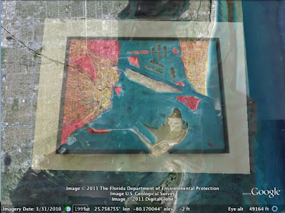
When we first hung up the paintings, we omitted location descriptions and opened a contest for the team: who could identify all of the paintings first? Google Earth Community Program Manager Robin Ziegler identified all of the locations about 30 hours after we started the challenge, and even plotted all of the paintings in Google Earth. Here you can see how Robin aligned Ben’s painting of Miami with the corresponding imagery in Google Earth.


Ben’s artwork will stay in our team’s building for the next three months, and will continue to remind us of the creative potential of geographic information.

Posted by Emily Henderson, Administrative Assistant, Google Maps & Earth
Read More
Posted in | No comments

Explore our U.S. Presidents on a map

Posted on 05:00 by Unknown

When I was in elementary school, I got two days off every February; one for George Washington and another for Abraham Lincoln. I remember classrooms were usually wallpapered with a potpourri of decorations left over from Valentine’s Day and token silhouettes of these two Presidents thumb-tacked to the bulletin board. My teachers would talk about the significance of the holiday during class but with lack of visuals to pique my interest, it was always hard to retain (and fully enjoy!) the information. With that in mind, we’re pleased to celebrate the President’s Day holiday in the U.S. by letting you go back in time to learn more about our past presidents in a visually fun and interactive way.

We’ve created a U.S. Presidents Showcase to map the birthplaces of all 44 presidents, and provide details about their presidential terms, using the Google Earth plug-in. You can also see the states that voted during each president’s election by clicking on the tours in the left column of the showcase.


Whether you’re a history buff or simply curious to learn more about U.S. presidents, we hope you enjoy exploring a little further using Google Earth. In addition to the U.S. Presidents map, educators can use some of our other resources in their classroom to explore more aspects of history. Here are a few ideas:
  • Explore the White House, Washington Monument, Lincoln Memorial and other historical monuments in 3D and have students explain how architecture is used to honor people, concepts and establishments
  • View a 3D model of Valley Forge National Park in Google Earth
  • View a copy of the Emancipation Proclamation signed by Abraham Lincoln and map the areas where slavery ended, as well as the areas that were not initially covered by this executive order
  • Discuss the famous painting “Washington Crossing the Delaware” by German American artist Emanuel Gottlieb Leutze and use the ruler tool in Google Earth to measure the width of the Delaware River
We hope you have fun exploring and learning a little more of the history behind the President’s Day holiday. And when you’re done, go out and enjoy your day off!

Posted by Tina Ornduff, Geo Education Program Manager
Read More
Posted in 3D, discovery, education, Google Earth, historical | No comments

Wednesday, 16 February 2011

Mapping favourite romantic movie scenes

Posted on 14:25 by Unknown

Last weekend, I was enjoying my favourite movie, Love Actually, which is a very appropriate movie to watch during the most romantic week of the year! The majority of this movie was filmed in and around my hometown of London, and as the ending film credits started rolling up the screen, I had a "eureka" moment. "I love this movie and I love Street View and Google Maps, so why not combine the two?" My virtual voyage of discovery began.

For those who like this movie, join me in this film tour across London. For those who haven’t seen the movie, I hope this blog post will help show how geography can help you to feel connected to something you are passionate about, such as places mentioned in your favourite songs or poems.

You may recognise this location as the London area home of the character "Jamie", played by Colin Firth, who meets his true love Aurelia while working on his novel in the south of France.


This next location is where Juliet, played by Keira Knightley, marries her husband Peter at the The Grosvenor Chapel‎ in Mayfair. Mark, Peter's best friend and a long suffering holder of unrequited love for Juliet, videotapes the ceremony.


When Juliet watches the video of the ceremony, focused entirely on her, she realises that Mark has feelings for her. Mark needs to get some fresh air, and this My Map I created shows the actual route Mark took for his walk.


This next spot, in Notting Hill, is where my favourite scene of the movie takes place. Yes, that's the one - where Mark holds up a series of cards to communicate his deepest feelings for Juliet.


This is where the film begins to build. The film’s British Prime Minister David, played by Hugh Grant, finally finds the courage to declare his feelings for Natalie, played by Martine McCutcheon. Knowing only the name of her street, her arrives to find what "must be the longest street in the world.” Driven by his desire to be with Natalie he starts to knock on every door, and eventually finds Natalie at number 102.


I hope this tour has inspired you to go and geographically organise what matters to you, just as this Jane Austen enthusiast did when she created a Google Earth project to geographically organise locations mentioned in Austen's novels.

Posted by Phil Verney, Program Manager, Google Earth & Maps
Read More
Posted in | No comments

Using My Maps for your summer sublet

Posted on 10:55 by Unknown
[Cross-posted from the Google Student Blog]

Today's guest author is Katie Corner, an Electrical and Computer Engineering student at University of Colorado, Boulder and a Google Student Ambassador. Check out more tips from students on the Google Student Blog, or submit your own to share.

The spring semester ends, and the frenzy begins: Quick, everyone find someone to sublet your apartment for the summer!

Hundreds of students in your university town will be simultaneously advertising their apartments to potential summer subletters. How can you help your apartment stand out among the crowd? Bring in Google Maps to save the day. Google Maps has a feature known as My Maps, which enables you to quickly and easily build a personalized map highlighting the locations you care about -- all on one map! Simply share the map link with your family or friends to let them see it too.

Everyone knows that when looking for a summer sublet, it’s all about location, location, location. Where are the closest grocery stores? What’s fun to do nearby? There’s a running path along the creek just two blocks away? And the local bus picks up on the corner? Nothing sells these points better than an easy, personalized map.

It only takes minutes to create your own My Map. To start, sign in to your Google account and go to maps.google.com. Click on the link in the upper-left corner labeled “My Maps.” By clicking the “Create new map” link, you can pick a title and get to building your housing map.

To start finding locations of interest and placing them on your new My Map, search for those places in Google Maps, for example “park in boulder co.” After finding the location you are interested in, simply click on the red pin on the map, followed by the “Save to...” link. From here you can easily select the new My Map you created.


After adding a number of specific locations to your map, you can also customize and edit the map to fit your style preferences. To access your map thus far, click on the “My Maps” link in the top left corner of the page, and select the map you are interested in editing. By clicking the “Edit” button, you are now in editing mode on the map and can easily make changes to the names of locations or the style of icon. To make a change to a specific place, just click on that location. On the map, an editable box appears where you can easily make changes, such adding as some notes about the place.


The end product is a unique map showcasing why your sublet is the right option to pick. Here’s an example I used for an apartment in Boulder, Colorado.

Stand out in your next apartment rental posting with My Maps today!

Posted by Katie Corner, University of Colorado
Read More
Posted in | No comments

Tuesday, 15 February 2011

Act Locally in Sudan with New Imagery & Maps

Posted on 16:30 by Unknown

After years of conflict, Southern Sudan overwhelmingly opted to secede from the country's north. Many challenges lie ahead as the newly independent state negotiates the rocky path towards independence. We believe that access to high-quality, up-to-date and locally relevant maps will assist humanitarian organizations working in the region.

We are encouraging users to add their local knowledge to this mapping effort through a campaign to build a better map of Sudan. Recent satellite imagery is key to building up-to-date maps, and we are continuously acquiring fresh and historical imagery of Sudan. Our latest imagery update is now live on Google Map Maker, Google Earth, and Google Maps, with nearly fifty percent of the UN priority areas over Southern Sudan covered with high resolution imagery. Thanks to our satellite partner GeoEye, we will continue to acquire and publish high resolution imagery of the remaining UN priority areas, as well as to refresh areas that we have previously covered as the need arises. This new imagery, such as the one over Melut, will directly benefit the many organizations working in Sudan and ultimately support the building of a solid basemap of Sudan to achieve long-term socioeconomic objectives.


Town of Melut (before 2/16/2004, after 1/30/2011). In Melut, there is a humanitarian hub where many services are delivered to at risk populations, including food, water, health care, education, and more. Given the varying needs of each of these services, maps can provide a variety of planning benefits for expansion, staff safety, and emergency procedures.

Google is also contributing to various humanitarian efforts, including the Satellite Sentinel project, by helping to build an active and self-sustained Sudanese mapping community -- locally and among the Sudanese diaspora. This community will help improve maps of Sudan by using Google Map Maker, a product that combines the power of mapping with community engagement.

Dedicated mappers have started building the foundation for a Sudan mapping community, resulting in high quality maps of Sudan. But this is a long term process that requires deep commitment from various stakeholders and community groups. To join the Sudan mapping efforts, and offer feedback, please join our Sudan community mailing list or visit our team site.

France Lamy, Program Manager, Google.org
Read More
Posted in Map Maker | No comments

Monday, 14 February 2011

Pin your love on the map

Posted on 02:43 by Unknown
(Cross-posted on the Official Google Blog)


This Valentine’s Day, tell your friends, family or significant other that you love them with a fun message from Google Maps.


Location can be a powerful trigger of memories—from the Italian place in San Francisco where you went on your first date to the cabin you rented at Lake Tahoe with your roommates. For that reason, we thought it would be great to create a Valentine’s Day card that’s tied to a specific location. As long as there’s a place that means something special to you and the ones you love, mapping your valentine is a great way to make Valentine’s Day a little more special.


One of my favorite memories is from a family trip we took to Eilat in Israel (check out my awesome fashion sense, I’m on the far left...), so I sent my parents this card:


I hope you'll take a moment to remind the people you love of the places you've shared with them. Visit www.mapyourvalentine.com to get started.

Happy Valentine's Day from Google!

Posted with love by Aaron Weissman, Google Maps & Earth Team
Read More
Posted in | No comments

Friday, 4 February 2011

Geotagging photos with Panoramio and Google Latitude

Posted on 07:45 by Unknown
[Cross-posted from the Panoramio Blog]


It is 9 a.m. and the thermometer shows -15°C. I have a Nexus S with Google Latitude in my left pocket and my new Lumix LX-5 in the right one. I am in Davos and I am ready for a fantastic day of skiing when I decide to use the new feature of Panoramio: geotagging photos with Google Latitude.


Panoramio is a community photos website that enables digital photographers to geo-locate, store and organize their photographs -- and to view those photographs in Google Earth.


Google Latitude allows you to share your location with friends and view their location on a map. When enabled, Google Latitude History allows you to store your previous locations and this allows you to match your photos with the locations stored in Google Latitude History.


By combining Panoramio and Google Latitude your photos get geotagged automatically as the time stamp of the photos is matched with your location record in Google Latitude History. To use this feature you need to explicitly enable it in your Settings page in Panoramio. With your permission, Panoramio will access your Google Latitude History to find out your location at the time when your photos are taken, so make sure the time in your camera is correct and it matches the value you entered in the Panoramio Settings page.


Using Google Latitude while skiing allows you to find your friends when you get lost on the slopes, and at the same time it allows you to focus on taking nice photos not worrying about the location where you are taking them.


Mapping photos within the city is normally not a problem as you can easily remember street names, points of interest, etc. It is much more difficult to do it in the countryside and that is why I decided to give the feature a whirl while skiing in Davos:


Thanks to Google Latitude, my photos were geotagged just after uploading them in Panoramio. The day was great, snow was perfect, weather was amazing and when I arrived home my photos were already geo-positioned.


For more information about this feature please check our help content and as always we will be happy to hear your feedback in the Panoramio forum.


Posted by Gerard Sanz, Panoramio Community Manager
Read More
Posted in education, Google Earth, Latitude, Panoramio, photos | No comments

Take a trip to the Super Bowl with Google Earth

Posted on 07:14 by Unknown

We’re two days away from one of my favorite events of the year, the Super Bowl (and I’m sure I’m not alone!). I’m one of those fans who starts watching football during pre-season and can have entire weekends ruined if my team loses. For me, the Super Bowl is the culmination of hours spent glued to the television and more hours doing post-game analysis (read: arguments) with fellow football enthusiasts.

However, what I love most about the Super Bowl is the tradition around it. It’s a time when friends and family get together and stuff their faces with nachos and beer, argue about who they wish were performing at halftime and watch the two best teams in the league slug it out for the storied Lombardi trophy. Even the commercials are good!

Unfortunately, not all of us can have the luxury of being at Cowboys Stadium – site of Super Bowl XLV – for the game, so we thought we’d offer users the next best thing: the Cowboys Stadium in 3D for Google Earth. Watch the video below to fly to Arlington, Texas and see the stadium in 3D.


You can also visit the stadium in Google Earth by searching for “Cowboys Stadium, Arlington TX” (make sure the 3D layer is turned on). Or, click here to see the area in your browser with Earth view in Google Maps.

We hope you enjoy the game as much as we will. Oh, and go Packers!

Posted by Gopal Shah, Google SketchUp team

Update: Go Steelers! -Nicholas Whitaker, Chief Steelers Evangelist
Read More
Posted in | No comments

Wednesday, 2 February 2011

It’s Groundhog Day!

Posted on 07:50 by Unknown
[Cross-posted from the SketchUp Blog]

Today is the 125th anniversary of Groundhog Day – a tradition in the US and Canada when a weather-predicting woodchuck named Punxsutawney Phil tells us how long winter will last. Every year on February 2, a group of local dignitaries hold a ceremony at Gobbler’s Knob, about 2 miles outside of Punxsutawney, Pennsylvania. Just after sunrise, Phil emerges from his burrow in front of thousands of spectators. The legend states that if Phil sees his shadow, there will be six more weeks of winter. No shadow means there will be an early spring.

Punxsutawney Phil in Google Earth

This year, Phil emerged at 7:25 AM and did not see his shadow! Despite the major winter storm stretching across 2,000 miles of the continent, it sounds like we’ll be enjoying an early spring!


You can check out Gobbler’s Knob by entering the coordinates 40°55'48.65"N, 78°57'27.53"W into Google Earth or by clicking here to see the area in your browser.


Posted by Zach Moore, 3D Data Specialist
Read More
Posted in | No comments

Tuesday, 1 February 2011

Google Hotpot now on Google.com and around the world

Posted on 18:10 by Unknown
[Cross-posted from the Hotpot Community Blog]

Back in November, we introduced Hotpot, a new local recommendation engine powered by you and your friends. Using Hotpot is simple: you rate places on google.com/hotpot—restaurants, hotels, cafes—and add friends on Hotpot whose opinions you trust. Then the next time you perform a search, Google will serve up personalized results, listing places based on your tastes, as well as recommendations from your friends.


We’ve watched Hotpot grow and change over the last couple months, and today Hotpot is really going places: to a Google search box near you and around the world.

You can now enjoy Hotpot recommendations in your regular search results on Google.com. So say you’re looking for a restaurant in Barcelona. Go to Google and search [restaurant barcelona]. If a friend has rated a particular restaurant, you might see their rating and what they had to say about it—as well as their name and photo—directly beneath that restaurant’s listing. To see all recommendations by your friends, click “Places” on the lefthand side of the page, and choose “Friends only.” Remember, you’ll need to be logged in to your Google account in order to see recommendations.


Seeing place recommendations based on your tastes and those of your friends across more Google searches will make results more relevant to you and maybe lead you to discover a new gem. If you don’t have Hotpot friends yet, you can invite them to share all the places they love with you by using the “Friends” tab on google.com/hotpot.

But Hotpot will only be half the fun if you can’t share it with all your international friends. So starting today, we’re making Hotpot available in 38 new languages—including Chinese, French, German, Italian, Korean, Polish, Russian and Spanish—allowing people to share their favorite places in their native language.

Start rating and sharing recommendations with Hotpot everywhere, anytime: at google.com/hotpot, on Google Maps, using Google Maps for Android with an easy widget, and on our new iPhone app.

Happy rating!

Posted by Lior Ron, Product Manager
Read More
Posted in Hotpot | No comments

Check in with Google Latitude

Posted on 10:30 by Unknown
[Cross-posted from the Official Google Blog]

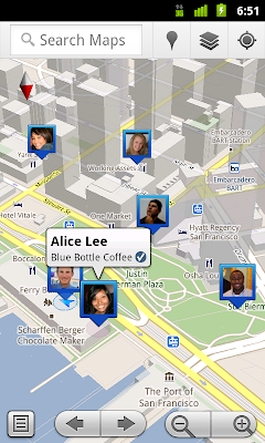
We first introduced Google Latitude to help you stay in touch with your friends and family by making it easy to share where you are. For the 10 million people actively using Latitude each month, this “where” has been a location on a map. Starting today in Google Maps 5.1 for Android, you can also connect that location to a real place by checking in there using Latitude.

Connecting your location with places
You can still use Latitude to automatically update and share your location, but check-ins let you add context to the location—like captions to a photo. For example, I live in San Francisco but often travel around the world. Until today, sharing my location let friends and family know if I was across the globe or in their neighborhood. Now, check-ins let them see the cool restaurant I’m trying in Taipei or join me for a latte at the cafe nearby.

See where your friends are on a map and where they’re checking in.

Not your typical check-ins
Because you can use Latitude to automatically detect your location, we’ve added a few twists to checking in to make it really easy:
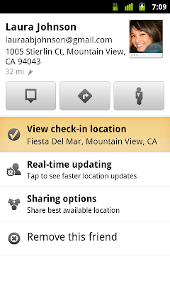
  • Notifications: Turn on check-in notifications in Latitude’s settings and get a notification to check in at a nearby place once you arrive. Never forget to check in again.
  • Automatic check-ins: Choose to automatically check in at specific places you designate, and you’ll be checked in when you’re there. You can talk to friends or finish your bagel without fumbling with your phone.
  • Check out: Once you leave, Latitude knows to automatically check you out of places so friends aren’t left guessing if you’re still there.


Explore your world one check-in at a time
Latitude is built right into Google Maps for Android so check-ins work across Latitude and Maps seamlessly. For example, check in at that new hamburger joint, and you’ll see its Place page with reviews to help you order. When friends check in at a place, you can go straight from their Latitude profile to its Place page to learn about it, fire up Google Maps Navigation (Beta) for turn-by-turn directions to them, and more.

You can also check in at a favorite place to earn special status there; you’ll see if you’ve become a “Regular,” a “VIP” or a “Guru” on its Place page. Keep checking in to hold onto your status or reach the next level.

Latitude check-ins are built right into Google Maps and Place pages.

Of course, we thought carefully about how to make checking in to places quick and easy while giving you control over your privacy. Just like when sharing your location with Latitude, checking in is 100% opt-in, and you can choose to share any check-in with your friends on Latitude, publicly on the web and your Google profile, or just yourself. Learn more about checking in and managing your check-ins with Latitude in the Help Center. Coming later this week, you’ll also be able to see your complete history of check-ins using the optional History tab at google.com/latitude from your computer.

Choose options for individual check-ins or turn on and off notifications in the Latitude settings.

Start checking in by downloading the latest Google Maps from Android Market (on Android 1.6+; tap here if you're on your phone) and then joining Latitude from the main menu. You can check in everywhere Maps and Latitude are already available. If you’re using the new Latitude app for iPhone, you’ll see your friends’ check-ins, and we’ll update the app soon so you can check in too.

Just the beginning...
Checking in from Latitude is just one step in helping you connect the places you go with the people you care about. We believe in letting you use or share your location however you like, and we’re working on making location and check-ins useful in more places—across Google and the web.

Posted by Joe LaPenna, Software Engineer, Google Latitude Team
Read More
Posted in Mobile | No comments

Street View takes you inside museums around the world

Posted on 09:05 by Unknown


We’re always excited to share new Street View imagery with users, whether a botanical garden in South Africa or ski slopes in Canada. While Street View has enabled users to visit places all around the world virtually, the demand to show a broader range of popular locations has been great. Today we’re entering new territory with our experiment to take Street View technology indoors.

The Art Project, developed by a group of art-loving Googlers, is a collaboration between Google and 17 of the world’s most acclaimed museums. Select works of art chosen by these partners are now available for you to explore through Street View in Google Maps, and the Art Project site offers an immersive experience to explore museum information, floor plans, more than 1000 high-resolution pieces, and Street View imagery. Learn more about the Art Project on the Official Google Blog.

To take you inside magnificent spaces like the State Hermitage Museum in St. Petersburg, Russia, our team needed to update the way we go about gathering Street View images.

The State Hermitage Museum, St. Petersburg, Russia

Street View imagery is typically collected using cars and we’re able to utilize the ample roof space and interior storage of these vehicles for all of our equipment. To take Street View technology indoors, we needed to fit all of the equipment on a much smaller vehicle, a push-cart lovingly dubbed Trolley.

Pictured with Trolley: Daniel Ratner, Mechanical Engineer and Matt Williams, Program Manager at the Van Gogh Museum in Amsterdam, The Netherlands

Trolley is outfitted with a few components that are key to collecting indoor imagery: a panoramic camera to collect 360-degree views, lasers to capture distances to walls, motion sensors to track Trolley’s position, a hard drive to store data, and a laptop to operate the system.

With this adapted equipment, we were able to gather the imagery and bring it into Google Maps, and you can now drag Pegman directly onto museums like the Metropolitan Museum of Art in New York City to explore their impressive European Paintings wing.

The Metropolitan Museum of Art, New York, United States

You can also enter museums when you’re already looking at Street View imagery of the museum exterior. You’ll notice new double-arrow navigation links from the nearby streets leading you inside, as you can see here for the Palace of Versailles.

Palace of Versailles, Versailles, France

Once inside the museum, you can navigate around rooms freely with the navigation arrows or simply click on a distant spot to jump to a closer view. Movement between floors can also be done with ease by selecting a different level from the new control panel below the Street View compass and zoom controls.

Alte Nationalgalerie, Berlin, Germany

We’re excited to introduce this new imagery in Street View, and will continue to improve and develop this indoor experience. To explore these museums directly through Street View in Google Maps, visit maps.google.com/museums, and to view high-resolution artwork and learn more about the museums, check out the Art Project at www.googleartproject.com.

Posted by Jonathan Siegel, Software Engineer
Read More
Posted in googlenew, Street View | No comments
Newer Posts Older Posts Home
Subscribe to: Posts (Atom)

Popular Posts

  • Take off for the holidays with Google Street View
    Whether it’s touring the canals of Venice , swimming with the seals in the Galapagos or climbing the Burj Khalifa in Dubai, Street View ha...
  • A bird’s eye view of The Queen’s Diamond Jubilee procession
    Following the royal wedding in 2011, the eyes of the world will again be on London as we celebrate the Diamond Jubilee of Queen Elizabeth I...
  • New Maps domains in 11 countries in Middle East & North Africa
    [Cross-posted from the Google Arabia Blog - in Arabic] With the growing numbers of Internet users in the region, we noticed that a huge num...
  • Apply now to be the next Google Maps Trekker
    We’re working to build the very best map of the world, and we’d love your help to do it. Today we’re kicking off a pilot program that enable...
  • See the seafloor like never before on World Oceans Day
    Only a tiny fraction of our oceans have ever been explored. As a matter of fact, we know more about the surfaces of Mars and the Moon than w...
  • Get a better view of natural geography with Google Maps
    When you look at Google Maps, we want you to see the most comprehensive, accurate and easy-to-understand representation of the entire world....
  • Help improve the “blue dot” for people visiting your venue
    When we announced the availability of indoor maps for Android last November , we also introduced Google Maps Floor Plans as a tool for busi...
  • Refocused Design Evolution, Continued
    In June we launched the start of a comprehensive visual redesign for Google Maps founded on three key principles: focus, elasticity, and ef...
  • Google Map Maker now available in South Africa and Egypt, and coming soon to more corners of the globe
    From the wild grasslands of Kruger National Park to the the extraordinary pyramids of Giza, the world is ripe with wonders waiting to be exp...
  • Visit the Hiroshima Peace Memorial in Street View
    We’ve added many historic sites to Street View to let you explore these places online, and now we’ve included Street View imagery of the Hir...

Categories

  • #treasuremap
  • +1
  • 3D
  • 8bitmaps
  • Adwords Express
  • Africa
  • Amazon
  • Andorra
  • Android
  • api
  • Art Project
  • Audi
  • biking
  • Boost
  • Boulder
  • Brazil
  • Bulgaria
  • Business Photos
  • Canada
  • check-in
  • community
  • competition
  • contest
  • crisis response
  • Culture
  • custom maps
  • developer
  • Developers
  • directions
  • disaster response
  • discovery
  • Download Free Nokia 6680 PC Suite
  • Download Micromax pc suite
  • Download Micromax pc suite for window
  • Download micromax Q5 Pc suite
  • Download PC suite
  • Download Samsung Mobile Pc Suite
  • earth outreach
  • education
  • Enterprise
  • Estonia
  • Europe
  • Fusion Tables
  • galaxy s2
  • Gibraltar
  • GMM
  • google
  • Google Earth
  • Google Earth Engine
  • Google Map Maker
  • Google Maps
  • Google Maps API
  • Google Maps Engine
  • Google Maps for Mobile
  • Google Maps Navigation
  • Google Maps Transit
  • Google Places
  • Google Plus
  • Google Search
  • Google Street View
  • google.org
  • Google+
  • googlenew
  • Grand Canyon
  • ground truth
  • Halloween
  • historical
  • history
  • Hotpot
  • HTC PC Suite Download
  • HTC PC suite for WIN 7
  • HTC PC Suite Free Download
  • HTC sync Downlaod
  • HTC Sync Download for windows
  • HTC Sync Free Download
  • Hungary
  • imager
  • imagery
  • Indoor Maps
  • iPhone
  • Iraq
  • Japan
  • Latitude
  • Latvia
  • layers
  • LG Mobile PC Suite
  • LG Mobile Support Tool
  • LG PC suite Download
  • Lithuania
  • London
  • Malaysia
  • Mall of America
  • Map Maker
  • mapsgl
  • Matt Harding
  • Mexico
  • Micromax A110
  • Micromax Canvas 2
  • Micromax pc suite download
  • Micromax PC suite for windows
  • Micromax Q5 FB PC Suite Free Download
  • Micromax Q5 FB PC Suite Free Download For Windows
  • Mircromax Q3 PC Suite Download for windows
  • Mobile
  • Monticello
  • My Maps
  • my places
  • my tracks
  • navigation
  • new Google Maps
  • Nokia 5250 PC Suite Free Download
  • Nokia 5530 PC Suite Free Download
  • Nokia 5610 PC Suite Free Download
  • Nokia 5800 PC Suite Free Download
  • Nokia 6030 PC Suite Free Download
  • Nokia 6680 PC Suite Download for windows
  • Nokia 6680 PC suite free Download
  • Nokia Asha 305
  • Nokia Asha 306 PC Suite download
  • Nokia C3-01
  • Nokia Free Suite
  • Nokia Mobile PC suite Download
  • oblique imagery
  • ocean
  • offline maps
  • Outreach
  • Pakistan
  • Panoramio
  • Parks Canada
  • Pegman
  • photo tours
  • photos
  • picasa
  • Quiz
  • real estate
  • Russia
  • Samsung C3322 PC Suite Free Download
  • Samsung C6712 PC Suite Free Download
  • Samsung Corby 2 PC Suite Free Download
  • Samsung Galaxy
  • Samsung Galaxy 5830 PC Suite Download
  • Samsung Galaxy Ace Hugo Boss
  • Samsung Galaxy Ace PC Suite Download
  • Samsung galaxy I8190 S III PC Suite Download
  • samsung galaxy mega
  • Samsung Galaxy Mega 5.8
  • Samsung Galaxy Mega 6.3
  • samsung galaxy s2
  • Samsung Galaxy Stratosphere II I415
  • samsung GT-I9100 pc suite
  • Samsung GT-S6102 Galaxy Y Duos PC Suite Download
  • Samsung GT-S6102 PC Suite Download
  • Samsung I9000 Galaxy S PC Suite Download
  • Samsung mobile pc suite downlaod
  • samsung mobile pc suite download for Windows 7 ad XP
  • samsung mobile pc suite download for Windows 7 and XP
  • Samsung N7100
  • Samsung Note 2
  • Samsung Note II
  • Samsung PC Suite Download.
  • Samsung Wave Y Drivers Download
  • Samsung Wave Y PC Suite Free Download
  • Santa
  • Santa Tracker
  • search stories
  • SketchUp
  • Slovakia
  • Slovenia
  • Sony PC Companion Free Download
  • Sony PC Suite Free Download
  • South Sudan
  • space
  • Spain
  • sports
  • Street View
  • Sumsang C3322 Drivers Download
  • SXSW
  • Tags
  • Thomas Jefferson
  • Thomas Jefferson Foundation
  • Tip of the week
  • tour guide
  • traffic
  • Train
  • Transit
  • trees
  • Trekker
  • U.S. National Park Service
  • Ukraine
  • University of Virginia
  • voice search
  • walking
  • Waze
  • weather
  • webgl
  • Xperia PC Suite Download
  • zagat

Blog Archive

  • ►  2013 (87)
    • ►  November (7)
    • ►  October (3)
    • ►  September (4)
    • ►  August (9)
    • ►  July (13)
    • ►  June (12)
    • ►  May (10)
    • ►  April (9)
    • ►  March (11)
    • ►  February (2)
    • ►  January (7)
  • ►  2012 (192)
    • ►  December (9)
    • ►  November (5)
    • ►  October (24)
    • ►  September (13)
    • ►  August (15)
    • ►  July (18)
    • ►  June (21)
    • ►  May (17)
    • ►  April (19)
    • ►  March (26)
    • ►  February (12)
    • ►  January (13)
  • ▼  2011 (234)
    • ►  December (13)
    • ►  November (17)
    • ►  October (19)
    • ►  September (15)
    • ►  August (23)
    • ►  July (25)
    • ►  June (20)
    • ►  May (20)
    • ►  April (23)
    • ►  March (24)
    • ▼  February (18)
      • Pedaling to new places with Street View
      • You’re invited to fly to the red carpet
      • Imagery Update - Week of February 21st
      • 5 great user-created maps chronicling Egypt
      • Join us on the bridge for International Women’s Da...
      • Mission Blue: Follow an Expedition off Easter Isla...
      • Geography as art
      • Explore our U.S. Presidents on a map
      • Mapping favourite romantic movie scenes
      • Using My Maps for your summer sublet
      • Act Locally in Sudan with New Imagery & Maps
      • Pin your love on the map
      • Geotagging photos with Panoramio and Google Latitude
      • Take a trip to the Super Bowl with Google Earth
      • It’s Groundhog Day!
      • Google Hotpot now on Google.com and around the world
      • Check in with Google Latitude
      • Street View takes you inside museums around the world
    • ►  January (17)
  • ►  2010 (21)
    • ►  December (21)
Powered by Blogger.

About Me

Unknown
View my complete profile