Your Mobile Support

  • Subscribe to our RSS feed.
  • Twitter
  • StumbleUpon
  • Reddit
  • Facebook
  • Digg

Friday, 23 December 2011

Santa Claus is coming to town... find out where with Google and NORAD

Posted on 06:00 by Unknown

(Cross-posted on the Official Google blog)

It’s that time of year again! The stockings are hung by the chimney with care and Google and NORAD are ready to answer the question of “where?”

NORAD’s tradition of tracking Santa on Christmas Eve started in 1955, when a Sears and Roebuck ad promoting the Talk-to-Santa hotline inadvertently sent callers to CONAD (NORAD’s predecessor) commander-in-chief’s operations hotline. After recovering from the surprise that the call was not from the Pentagon or the White House but instead a little boy inquiring if the commander was Santa Claus, Colonel Harry Shoup asked his team to check their radar for signs of Santa’s sleigh and a tradition was born.

The Santa tracking tradition has grown over the years and today it’s also possible to track Santa using Google Earth and Google Maps on the NORAD Santa site, and on your mobile phone as well. Starting tomorrow (Saturday, December 24) at 2:00 a.m. EST, visit www.noradsanta.org to follow Santa’s journey from the North Pole to homes all over the globe. This year there are many ways to keep tabs on Santa’s sleigh, no matter how quickly it moves:
  • Follow Santa on Google Maps: Visit www.noradsanta.org to see where Santa is currently flying and where he’s headed next on Google Maps. Click on the video icons to watch “Santa cam” videos from all over the world, and the gift icons will display information about each city along the route.
  • Watch Santa fly in 3D with the Google Earth plug-in: If you have the Google Earth plug-in installed on your computer, you can track Santa’s location in 3D and see him deliver presents everywhere from the mountain villages of the Swiss Alps to the white sand beaches of Hawaii.
  • Track Santa from your mobile phone: Follow Santa on the go by searching for [santa] on the Google Maps for mobile app.
  • Get updates via social media: The NORAD team will be posting updates about Santa’s flight throughout the day on December 24. Follow them on Google+, Twitter or Facebook for live updates.
  • Subscribe to the NORAD Tracks Santa YouTube channel: All “Santa cam” videos will be posted on the NORAD Tracks Santa YouTube channel as they’re captured. You can also watch a recap of Santa’s 2010 trip. Check back often for updates!
Santa flying over London in Google Earth

NORAD Tracks Santa is a special project near and dear to all of us involved. I started working on the program seven years ago and it’s been a thrill to watch it grow over the years. Recently, I was given the opportunity to speak at TEDActive about the origins of NORAD Tracks Santa and how Google has brought this to life in Google Earth.


I’d like to thank all of Santa’s “elves” that helped out across Google and NORAD far and wide. Happy Holidays!

Posted by Bruno Bowden, Lead Google Engineering Elf
Read More
Posted in Google Earth, Google Maps, Santa | No comments

Tuesday, 20 December 2011

New 45° imagery for Detroit and 4 other cities

Posted on 08:21 by Unknown
Earlier this month we highlighted 21 new cities with updated 45° imagery on Google Maps. In our last 45° imagery update of the year, we have 5 new cities from the Midwestern and Southern regions of the US.

Detroit, Michigan is one of those cities I’m particularly excited to share with you. Growing up nearby this great international city, I’ve gotten to know its beauty, character and deep history. Recently Detroit has attracted much international attention for its auto sector and changing urban landscape.

With this 45° imagery update, and also using the Street View feature of Google Maps, you can now explore for yourself the wonderful revival that has happened in Detroit’s downtown core. Here at the corner of Montcalm and Woodward you can see the historic Fox Theatre and the famed Hockeytown Cafe, with the home of the Detroit Tigers and Lions just a short walk away:

View Larger Map

(If you’re feeling nostalgic, you can even have a look at what the site of the old Tiger Stadium now looks like!)

You can also view some of Detroit’s stunning architecture, among the most beautiful in North America. The GM Renaissance Center standing proudly among many of the majestic 1920s era office buildings is a poignant contrast of Detroit’s history and progress:


View Larger Map

This new 45° imagery in Detroit extends a few neighborhoods in each direction of the downtown area so I encourage you to zoom in and rotate the compass ring to explore this great city from the air!

While you’re at it, be sure to take a look at other new updates in these US cities:

Fayetteville, AR, Nashville-Franklin, TN, Baton Rouge, LA, Huntsville, AL

Posted By Mike Pegg, Google Marketing
Read More
Posted in 3D, Google Earth, Google Maps, imager, oblique imagery | No comments

Thursday, 15 December 2011

Imagery Update: Week of December 12th

Posted on 12:00 by Unknown

The Google Earth and Maps Imagery Team has done it again, delivering another collection of updated aerial and satellite imagery from around the globe, just in time for the holidays. Below we’ll show several new high-resolution aerial imagery examples of important locations and landmarks of where large groups of people congregate.

Our first example is known the world over and houses one of the most impressive art collections ever assembled: the Louvre in Paris, France. The right half of the aerial image below shows the entire museum grounds, and the left center section is the garden and palace of past cardinals and kings, the Jardin du Palais Royal.

The Louve and Jardin du Palais Royal, Paris, France 

The next example is an aerial shot of the grounds of the United States Military Academy at West Point, New York. The lower right section shows part of the campus grounds and athletic fields, and the upper left shows Mitchie Stadium, home of the Black Knights football team. Army played the Navy Midshipmen for the 112th time this past week, narrowly losing to Navy in one of the more exciting meetings in their storied rivalry.

United States Military Academy, West Point, New York

The image below is an aerial shot of the Empire Polo Club in Indio California, site of the annual Coachella Valley Music and Arts Festival. It looks empty now, but this past year’s festival drew over 75,000 attendees on each day, and a total of 190 musical acts. Rock on!

The Polo Grounds, Indio, California

Speaking of rock concerts, the unassuming black-roofed building at the center of the aerial image below is home to the 40 Watt Club venue that helped launch the American punk and New-Wave music genres. It’s the place where the band R.E.M launched their career.


Home of the 40 Watt Club, Athens, Georgia

If you’d like to receive an email notification when the Google Earth and Maps Imagery team updates your favorite site(s), we’ve got just the tool: The Follow Your World application!

These are only a few examples of the types of features that can be seen and discovered in our latest batch of published imagery. Happy exploring!

High resolution aerial updates:
USA: Athens, GA; College Station, TX; Palm Springs, CA; Pine Bluff, AR; Meridian, MS; Poughkeepsie, NY; Rockdale, TX; Rutland, VT; St George, UT; Seguin, TX; Seminole, TX; Sonora, TX; Stockton, CA; Waco, TX

Spain: Catalonia, Zamora

France: Paris

Countries/regions receiving high resolution satellite updates:
Algeria, Argentina, Australia, Austria, Bangladesh, Belarus, Benin, Bhutan, Bolivia, Botswana, Brazil, Bulgaria, Burkina Faso, Burundi, Cameroon, Canada, Cape Verde, Central African Republic, Chad, Chile, China, Colombia, Comoros, Costa Rica, Croatia, Cuba, Cyprus, Czech Republic, Côte d'Ivoire, Democratic Republic of the Congo, Djibouti, Dominican Republic, Ecuador, Egypt, Eritrea, Ethiopia, Finland, France, French Polynesia, Germany, Ghana, Greece, Greenland, Guatemala, Guinea, Haiti, Honduras, Hungary, India, Indonesia, Iran, Ireland, Italy, Japan, Jordan, Kazakhstan, Kenya, Kuwait, Lesotho, Libya, Madagascar, Malawi, Marshall Islands, Mexico, Mongolia, Morocco, Mozambique, Myanmar, Namibia, Nepal, New Zealand, Niger, Nigeria, North Korea, Oman, Pakistan, Papua New Guinea, Paraguay, Peru, Philippines, Poland, Portugal, Qatar, Republic of Korea, Romania, Russia, Rwanda, Saudi Arabia, Senegal, Serbia, Sierra Leone, Slovakia, Somalia, South Africa, Spain, Sri Lanka, Sudan, Svalbard, Swaziland, Sweden, Switzerland, Syria, Tajikistan, Tanzania, Thailand, Togo, Tunisia, Turkey, Uganda, Ukraine, United Arab Emirates, United Kingdom, United States, Uruguay, Uzbekistan, Venezuela, Vietnam, West Bank, Yemen, Zambia, Zimbabwe

These updates are now available in both Google Maps and Google Earth. For a complete picture of where we updated imagery, download this KML for viewing in Google Earth.

Posted by Eric Kolb, Geo Data Strategist
Read More
Posted in Google Earth, imagery | No comments

Wednesday, 14 December 2011

Mapping made easier with the new Google Map Maker

Posted on 07:00 by Unknown

With 2012 approaching, we're getting a head start on our New Year's resolution to shed some excess weight and improve our overall appearance. You may have seen our ongoing efforts to improve the look, feel, and user experience across many other Google products to date. And with Google Map Maker available in the United States, Canada, and more than 180 other regions, it's time for another makeover. Today, we’re revealing a new version of Google Map Maker to help users map the places they know best and make their hometowns sparkle on Google Maps.


Start with a walkthrough of the new Google Map Maker

With Map Maker, you can easily help ensure that the changing world around you is accurately reflected on the map. Add your favorite gift shop, the nearest tree farm, or even the golf course where you once got that hole in one. It’s also easier to mark the best route to Grandma’s house and draw better buildings with courtyards and crisper corners. The options are endless when it comes to mapping the places you know and love. Once approved, your contributions will appear on Google Maps, Google Earth and Google Maps for mobile for all the world to see.


You don’t have to be an expert to start using Google Map Maker. High school student and Eagle Scout Tommy Bruce is a mapping superstar who finds mapping fun, fulfilling, and a simple way to help those in his community have the best, most comprehensive information possible. He started by mapping bike trails in his hometown of Mooresville, North Carolina and is now on an exchange program in Puebla, Mexico, mapping unmarked rivers that run through town! After witnessing Tommy’s accomplishments firsthand at the U.S. Geo User Summit, even his mother Margaret began thinking of places that she’s eager to put on the map. Why not make your New Year’s resolution to improve the map for millions of people? Start here.

Posted by Kaushik Sridharan, Software Engineer
Read More
Posted in community, Google Maps, googlenew, Map Maker | No comments

Monday, 12 December 2011

Experience the tsunami-affected areas of Japan through Street View

Posted on 18:00 by Unknown
(Cross posted on Official Google Blog)

Back in July, we announced our initiative to digitally archive the areas of Northeastern Japan affected by the March 11 earthquake and tsunami. Today, we’re making good on that promise—after driving more than 44,000 kilometers through the affected regions, 360-degree panoramic imagery of those areas is now available through the Street View feature in Google Maps. The images can also be viewed via a special website called “Memories for the Future,” where you can easily compare before and after shots of the towns changed by these events.

A virtual tour via Street View profoundly illustrates how much these natural disasters have transformed these communities. If you start inland and venture out toward the coast, you’ll see the idyllic countryside change dramatically, becoming cluttered with mountains of rubble and debris as you get closer to the ocean. In the cities, buildings that once stood proud are now empty spaces.


View Larger Map

In the bottom left corner of each image you’ll also see a month and year that tells you when a particular photograph was taken. When looking at images of the magnificent cities side-by-side with images of the ruins left in their place, this additional context demonstrates how truly life-changing this tragedy has been for those who live there and witnessed the destruction of their homes, neighborhoods and even entire districts. This timestamp feature has been the most requested Street View feature for the last few years, and it is now available on Street View imagery worldwide. Professionals such as historians, architects, city planners and tourism boards—as well as regular users including travelers and home-buyers—can now get a sense of how fresh the online photos are for a locations that interests them.

In the case of the post-tsunami imagery of Japan, we hope this particular digital archiving project will be useful to researchers and scientists who study the effects of natural disasters. We also believe that the imagery is a useful tool for anyone around the world who wants to better understand the extent of the damage. Seeing the street-level imagery of the affected areas puts the plight of these communities into perspective and ensures that the memories of the disaster remain relevant and tangible for future generations.

Posted by Kei Kawai, Senior Product Manager, Street View
Read More
Posted in Google Maps, imagery, Street View | No comments

New 45° imagery available for 21 cities

Posted on 14:00 by Unknown

Viewing 45° imagery can make the map much more fun and informative by enabling you to see a tilted aerial perspective of some of your favorite spots. In this month’s 45° imagery update in Google Maps, I highlight one of my favorite towns in Colorado.

Boulder, Colorado is a mecca for outdoor hiking, cycling, and climbing excursions and 45° imagery can help users plan their adventures. Located at the base of the Rocky Mountains, Boulder is at an elevation of 5,430 feet (1,655m) above sea level which makes for fun terrain to look at from a bird’s eye view. Here’s an image of Folsom Stadium at the University of Colorado, Boulder:

View Larger Map

The “Strip” in Las Vegas, Nevada is also included in the latest batch of 45° imagery. Now you can see the some of the large casinos and resorts that dot the famous Las Vegas Boulevard.

View Larger Map


Next we head to the southern hemisphere to Brasilia, the capital of Brazil. The city sits high up on a plateau and some say the aerial view of Brasilia resembles an airplane. Now you can fly even closer and get a 45° look.

View Larger Map

Happy exploring!

Here is a list of updated cities:

U.S.
Albuquerque (west), NM; Benton, AR; Boulder, CO; Eldridge, IA; Boston (east), MA; Centennial (south), CO; GooglePlex, CA; Indianapolis (south), IN; Las Vegas Strip, NV; Montgomery (outskirts), AL; Olathe, KA; Petaluma, CA; Tulsa, OK

South America
Brasilia, Brazil

Posted by Wayne Thai, Geo Data Strategist
Read More
Posted in Google Maps, imagery, oblique imagery | No comments

A new view of Google Earth on 48 screens

Posted on 10:15 by Unknown

Back in 2009, Google developed the first Liquid Galaxy, an entirely new way to display Google Earth on eight screens - which creates an immersive experience of virtually flying around the globe. Since then, we’ve built dozens of Liquid Galaxies all over the world and open sourced the code so anyone can build their own.

Late last year, the Paris Center for Architecture and Urbanism: Le Pavillon de l’Arsenal, approached us asking if they could use Google Earth to power a new interactive display highlighting the Paris metropolitan area in 2020 with upcoming buildings in 3D. Naturally, we were excited about the project, especially when they shared that the display would be 40 square meters - posing a fun and unique challenge.

A year later, we are excited to share that the first 48 screen Liquid Galaxy is now on display in Paris. We believe this to be the largest screen showing Google Earth to date!

Photo: Vincent Fillon

What started as a 20% project to support the new Google Cultural Institute resulted in a stunning display of the Earth in almost 100M pixels - powered by 48 instances of Google Earth synchronized and operated through 4 multi-touch screens with pinch and zoom functionality. The view is even sharper due to a refresh of the entire Paris area with higher resolution imagery.

As a Parisian, it’s amazing to be able to see what the city will look like in the future. If you can’t make it to France in the near future, you can preview it at home by downloading this KML file and opening it in Google Earth.

The Canopy and Transport Hub: Patrick Berger and Jacques Anziutti architects

This project was a close collaboration between Google and Le Pavillon de l’Arsenal, as well as technology JCDecaux, End Point and design partners ultranoir.


Over the next few months we’ll be fully open sourcing this work on Liquid Galaxy, as well as the graphical interface. Keep an eye out on our source code page for updates.

Posted by Pierre Lebeau, Product Manager
Read More
Posted in Google Earth | No comments

Friday, 9 December 2011

New Cities in 3D - Rome, Seville, Las Vegas, and more.

Posted on 09:00 by Unknown

Google Maps continuously works to bring you real-life 3D representations of your favorite cities from around the world. Google Maps in 3D combines a functional map with stunning visuals. You can tour an increasing number of cities in 3D and experience the streets and sights right from your computer or Android device.

Since embarking on our 3D mapping efforts, we have amassed a collection of cities that allows you to feel like a jet-setter. We have recently expanded and improved this collection to include more cities in Europe and the US, to name a few. You can experience a few cities below.

Hop on your scooter and take a romantic tour through Rome, Italy.

View Larger Map

Tour Seville, the artistic, historic, and cultural capital of southern Spain.

View Larger Map

Or take a look at the casino resorts that dot the Las Vegas Strip which has also been updated with 45 degree satellite imagery as well.

View Larger Map

New 3D maps coverage is available in:

US: Foster City, Honolulu, Las Vegas, Norfolk,Palo Alto, Portland, Redwood City, Riverside, Salt Lake City, San Antonio, San Diego, Santa Cruz, Sunnyvale.
Europe: Rome, IT, Rotterdam, NL; Seville, ES; Stuttgart, DE, Amsterdam, NL

Posted by Brian Brewington, Google Maps
Read More
Posted in 3D, Google Maps, Mobile | No comments

Thursday, 8 December 2011

Updating the Maps of the United Kingdom, Germany, Finland and Sweden

Posted on 15:56 by Unknown

As always, our team continues to work hard to provide up-to-date and accurate base map data for places around the world. Today, we are happy to announce updated maps for the UK, Germany, Finland and Sweden.

You may notice many improvements to Google Maps in these countries, such as improved water bodies and more comprehensive local park coverage. Many of these and other changes are the result of us working directly with a variety of organizations, agencies and data providers. For example, Germany's Federal Agency for Cartography and Geodesy (Bundesamt für Kartographie und Geodäsie) supplied us harmonized data from surveying and mapping agencies of all 16 federal states (Länder). And in the case of Finland, we acquired water body data directly from the National Land Survey. We're thankful to these and other data providers for helping us ensure that our digital maps accurately reflect real life.

We’d also like to thank all our users who report problems and help make Google Maps better for everyone. Starting today, the “Report a Problem” tool will appear in the lower right corner of the map for the UK, Germany, Finland and Sweden. So, if you see anything amiss, do let us know and we’ll do our best to update the map as quickly as possible, sometimes within just a few days!


Posted by Valient Gough, Software Engineer
Read More
Posted in Google Maps | No comments

Exploring ancient ruins in 3D with Google Earth

Posted on 13:00 by Unknown

(Cross-posted on the Inside Search Blog)

Searches can become stories. Some inspire us, others change the way we see the world or just make us smile. This is the latest in a series of videos about people who have used Google to discover or do something extraordinary.

The field of archaeology has changed much over the years. New modes of transportation have made even the most remote sites accessible, while cameras simplify how a historical record is created and shared with the world.

Spurred on by these innovations, researchers are also embracing technology as a creative way to aid their research and explore ancient sites. To conduct archaeological studies in the Middle East, Professor David Kennedy of the University of Western Australia turned to Google Earth.

From his office chair in Perth, Professor Kennedy has remotely identified thousands of archaeological sites without having to step foot on Saudi Arabian or Yemeni soil. Historically it has been difficult to undertake ground surveys and aerial photographs of these areas are seldom available for research, making the countries some of the least explored archaeologically. By carefully studying satellite imagery of the Arabian peninsula in Google Earth, Professor Kennedy has unearthed an enormous record of archaeological sites, from ancient geoglyphs to stone Wheels to Pendant-shaped tombs and animal traps called kites that could be up to 9,000 years old.

Watch Professor Kennedy’s Search Story video to see how Google Earth aided his search for these ancient sites across the Middle East.


Professor Kennedy isn’t the only archaeologist to discover the potential in using satellite imagery to aid traditional field methods. Visit www.OneWorldManyStories.com to discover how the scientific community has used Google Earth to uncover ancient relics, find a new hominid ancestor, identify hidden forests, and put craters on the map.

Do you have a great Google Earth story? Share it with us.

Posted by Vicky Homan, Google Earth Product Marketing
Read More
Posted in Google Earth, search stories | No comments

Tuesday, 6 December 2011

Looking for stores in a shopping mall or doctors in a hospital?

Posted on 07:00 by Unknown

As the holiday shopping season kicks into high gear, being a well-informed and efficient shopper is more important than ever. That’s why we’re excited to introduce a new feature in Google Maps that can help you find places that are located within or are part of larger buildings, such as malls, office buildings, and hospitals.


When appropriate, the name of the overarching location will be added to the listings that appear in Google Maps, just beneath a place’s address. For example, you can now easily tell that the Disney Store near you isn’t a standalone store, but rather, located at the Hillsdale Shopping Center. Similarly, you can more easily see that a specific doctor’s office is at the Palo Alto Medical Foundation, or that the restaurant you’re looking for is actually in the same structure as a local hotel.

Labels for the shopping malls where a store is located
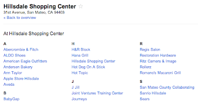
If you click on the name of the overarching location - in this case, Hillsdale Shopping Center -  you’ll see a detailed list of all the businesses or professionals at that particular location. Up to 20 listings are provided, and clicking the “More at...” link will give you the complete list.

List of stores and restaurants located at the shopping mall
This feature is available starting today for a variety of U.S. locations and venue types, and we hope to expand it to more categories and countries over time.

Happy holiday shopping!

Posted by Sean Wonjoon Choi, Product Manager
Read More
Posted in Google Maps | No comments

Monday, 5 December 2011

Pedal to find your dream home with Google Maps

Posted on 06:33 by Unknown

The features available in Google Maps are equally functional and fun. You can tour distant cities with Street View or map out a trip with multiple destinations using Custom Maps. Not only is Google Maps a great tool for everyday personal use, but it’s can also be used as a practical business tool. Such is the case for Matt Kolb, owner of Pedal to Properties.

Matt is an avid cyclist and a realtor based in Boulder, Colorado. In 2006, Matt decided to blend his hobby and career by founding his own real estate agency called Pedal to Properties. His company is built on the idea that by touring homes via bicycle, one can get a better sense of the local community and determine if a particular property is the right fit.


When Matt meets with clients, he locates various properties on Google Maps and creates a biking route of the houses they’ll visit that day, using Bicycling Directions as a guide. Home buyers are encouraged to interact with the map, using Street View to check out a property and its surrounding neighborhood, and using nearby search to take a look at local schools and businesses. Through this process Matt is able to narrow down viable homes for a specific buyer, making the experience enjoyable and time-efficient.

If you have interesting stories about how you use biking directions, Street View, or other Google Maps features to enhance your business, comment on our Google+ Page with #mygmapstory

Posted by Dave Kim, Product Marketing Manager
Read More
Posted in biking, Boulder, Google Maps, My Maps, Street View | No comments

Thursday, 1 December 2011

Here comes Santa Claus

Posted on 09:00 by Unknown

Whether you know him as Père Noël, Weihnachtsmann, Babbo Natale, Father Christmas, Saint Nicholas or Santa Claus, there’s a chance you’re anticipating a visit from the jolly old man this December 24. Although he goes by many different names, the magic he brings to the holidays is felt by children and adults celebrating Christmas all over the world.

Growing up in Lawrence, Kansas, I have fond memories of racing to the tree Christmas morning to see what Santa left during his stop in my town. Sometimes it took a lot of work to stay on the right side of the “naughty or nice” list, but Santa came through for me every year.

Like most traditions, this one has evolved over time. Now, in addition to racing downstairs to their stockings, children can follow Santa online on his annual trip from the North Pole to their chimney. With NORAD Tracks Santa, children and families can watch Santa as he delivers presents all over the globe (with a little help from the North American Aerospace Defense Command). If you haven't yet followed this tradition in your family, we'd like to invite you to join us this Christmas Eve.

The countdown to track Santa begins today. Visit www.noradsanta.org the entire month of December to play holiday games and learn fun facts about NORAD and Santa. Set a reminder for 2 a.m. EST on December 24 to start tracking Santa in real-time on the website using Google Maps, and in 3D with Google Earth. If your phone is handy on Christmas Eve, you can also search for [santa] on Google Maps for mobile to track his journey on the go.

Wherever you are, we look forward to counting down to the holidays with you at www.noradsanta.org. Be sure to finish all your holiday shopping in time so you can join us for the main event on December 24.

In the meantime, to get into the Santa tracking spirit, follow NORAD Tracks Santa on Google+ and enjoy a few highlights from last year’s journey in this video:


Posted by Brian McClendon, VP of Engineering, Google Earth and Maps
Read More
Posted in Google Earth, Google Maps, Google+, Santa | No comments

Wednesday, 30 November 2011

Imagery Update: Week of November 28th

Posted on 14:30 by Unknown

The winter and holiday seasons are quickly approaching but that hasn’t stopped the Google Earth and Maps Imagery Team from updating aerial and satellite imagery throughout the globe. Today, we’d like to share several interesting features identified in this latest release.

The first example shown below is part of an aerial image acquired this past September of the ski slopes in Breckenridge, Colorado. The slopes have already accumulated several inches of snow over the past few weeks and although it’s still very early in the ski season, a third of all ski lifts are now open! If you can’t make it to the mountains quite yet, be sure to experience the next best thing with Street View imagery from some of the most popular ski destinations.

Perspective view of ski slopes in Breckenridge, Colorado

Philadelphia, Pennsylvania is full of iconic landmarks from American history. The aerial image shown below, which was acquired this past October, shows some of the most well known buildings along the east bank of the Schuylkill River. At the bottom left of the image are the fifteen structures comprising Boathouse Row, and the upper right shows the Fairmount Water Works and the Philadelphia Museum of Art. In the far right corner of the image are the stone steps made famous in the Rocky movies.

Boathouse Row, Fairmount Water Works and the Philadelphia Museum of Art, Philadelphia, Pennsylvania

“X” marks the spot in the satellite image below of part of Miramar, Argentina. Of course, the feature is comprised of roads that lead to the town’s central sculpture, Monumento al Gral Alvarado, and the four parks comprising the central plaza.

Miramar, Argentina

As we close in on the Christmas season, it seems appropriate to feature several well known churches that have been updated with new imagery. The first example, shown below, is aerial imagery of the Basilica of the Assumption of the Blessed Virgin Mary, in Gdańsk, Poland. The structure is considered one of the largest Brick Gothic buildings ever constructed, and has sufficient space to hold 25,000 people!

Basilica of the Assumption of the Blessed Virgin Mary, Gdańsk, Poland

This next example shows updated aerial imagery of Burgos, Spain. In the upper left, is the Burgos Castle, overlooking the Burgos Cathedral in the lower right. This cathedral is famous for its vast size and unique French Gothic architecture.

Burgos, Spain

Finally, below is an updated image of the Calvary Baptist Church of Hi Vista, California, perhaps one of the more notable churches of late. This church was of course used famously in the Kill Bill Vol. I movie as the site of near demise for the heroine, “The Bride.”

Calvary Baptist Church, Hi Vista, California

If you’d like to receive an email notification when the Google Earth and Maps Imagery team updates your favorite site(s), we’ve got just the tool: The Follow Your World application!

These are only a few examples of the types of features that can be seen and discovered in our latest batch of published imagery. Happy exploring!

High resolution aerial updates:
USA: Alamosa, CO; Albany, NY; Altoona, PA; Atlanta, GA; Bartlesville, OK; Bishop, CA; Boise City, OK; Clarksville, TN; Clayton, NM; Edwards, CA; Erie, PA; Georgetown, SC; Great Bend, KS; Guymon, OK; Hot Springs, AR; Lamar, CO; Lawton, OK; Llano, TX; McAlester, OK; Merced, CA; Oklahoma City, OK; Palmdale, CA; Philadelphia, PA; Redding, CA; Roseburg, OR; Scranton, PA; Springfield, MO; Texarkana, TX; Twin Falls, ID; Vail, CO

Poland: Bielsko-Biala, Lubaczowski, Malborski, Mazowieckie, Mielecki, Wolowski, Wolczyn,

Spain: Burgos

Switzerland: Horgen

Countries/regions receiving high resolution satellite updates:
Algeria, Argentina, Australia, Austria, Bangladesh, Belarus, Benin, Bhutan, Bolivia, Botswana, Brazil, Bulgaria, Burkina Faso, Burundi, Cameroon, Canada, Cape Verde, Central African Republic, Chad, Chile, China, Colombia, Comoros, Costa Rica, Croatia, Cuba, Cyprus, Czech Republic, Côte d'Ivoire, Democratic Republic of the Congo, Djibouti, Dominican Republic, Ecuador, Egypt, Eritrea, Ethiopia, Finland, France, French Polynesia, Germany, Ghana, Greece, Greenland, Guatemala, Guinea, Haiti, Honduras, Hungary, India, Indonesia, Iran, Ireland, Italy, Japan, Jordan, Kazakhstan, Kenya, Kuwait, Lesotho, Libya, Madagascar, Malawi, Marshall Islands, Mexico, Mongolia, Morocco, Mozambique, Myanmar, Namibia, Nepal, New Zealand, Niger, Nigeria, North Korea, Oman, Pakistan, Papua New Guinea, Paraguay, Peru, Philippines, Poland, Portugal, Qatar, Republic of Korea, Romania, Russia, Rwanda, Saudi Arabia, Senegal, Serbia, Sierra Leone, Slovakia, Somalia, South Africa, Spain, Sri Lanka, Sudan, Svalbard, Swaziland, Sweden, Switzerland, Syria, Tajikistan, Tanzania, Thailand, Togo, Tunisia, Turkey, Uganda, Ukraine, United Arab Emirates, United Kingdom, United States, Uruguay, Uzbekistan, Venezuela, Vietnam, West Bank, Yemen, Zambia, Zimbabwe

These updates are now available in both Google Maps and Google Earth. For a complete picture of where we updated imagery, download this KML for viewing in Google Earth.

Posted by Eric Kolb, Geo Data Strategist
Read More
Posted in Google Earth, Google Maps, imagery | No comments

Tuesday, 29 November 2011

A new frontier for Google Maps: mapping the indoors

Posted on 09:33 by Unknown
(Cross-posted on the Official Google Blog)

“Where am I?” and “What’s around me?” are two questions that cartographers, and Google Maps, strive to answer. With Google Maps’ “My Location” feature, which shows your location as a blue dot, you can see where you are on the map to avoid walking the wrong direction on city streets, or to get your bearings if you’re hiking an unfamiliar trail. Google Maps also displays additional details, such as places, landmarks and geographical features, to give you context about what’s nearby. And now, Google Maps for Android enables you to figure out where you are and see where you might want to go when you’re indoors.


When you’re inside an airport, shopping mall or retail store, a common way to figure out where you are is to look for a freestanding map directory or ask an employee for help. Starting today, with the release of Google Maps 6.0 for Android, that directory is brought to the palm of your hands, helping you determine where you are, what floor you're on, and where to go indoors.


Detailed floor plans automatically appear when you’re viewing the map and zoomed in on a building where indoor map data is available. The familiar “blue dot” icon indicates your location within several meters, and when you move up or down a level in a building with multiple floors, the interface will automatically update to display which floor you’re on. All this is achieved by using an approach similar to that of ‘My Location’ for outdoor spaces, but fine tuned for indoors.

Mall of America in Minneapolis before and after, with a floor selector

San Francisco International Airport before and after, with 3D tilt

We’ve initially partnered with some of the largest retailers, airports and transit stations in the U.S. and Japan, including:
  • Mall of America, IKEA, The Home Depot, select Macy’s and Bloomingdale’s, Daimaru, Takashimaya and Mitsukoshi locations and more. Watch an IKEA demo here.
  • Hartsfield-Jackson Atlanta International Airport (ATL), Chicago O’Hare (ORD), San Francisco International Airport (SFO) and Narita International (NRT), among others.
  • JR and Tokyu Corporation
For a detailed list of participating locations, please visit our help center. And this is just the start--we’ll continually add new indoor maps to public buildings across the world. If you’re a business owner interested in getting your location’s floor plan included in Google Maps, visit maps.google.com/floorplans.

We’re thrilled Google Maps continues to provide you with new and helpful perspectives—whether you’re rushing through the airport or finding your way around a mall. To visit our website and learn more about indoor Google Maps and other features, start here.

Posted by Brian McClendon, VP of Engineering, Google Earth and Maps
Read More
Posted in Google Maps, Indoor Maps, Mobile | No comments

Monday, 28 November 2011

Visualizing water and energy solutions in a warming world

Posted on 16:00 by Unknown

Editor’s Note: Today’s guest author is Zachary Hurwitz from International Rivers, an environmental and human rights organization with staff in four continents, who has worked to protect rivers and the rights of communities that depend on them for over 25 years. International Rivers was the recipient of a Google Earth Outreach Developer Grant, funded through the Google Inc. Charitable Giving Fund at the Tides Foundation. We are excited to showcase International River’s innovative use of Google Earth and KML tours.

Today, the COP17 climate meeting starts in Durban, South Africa. The climate meeting is themed “saving tomorrow today.” One hot topic currently being discussed is the construction of dozens of mega-dams for Africa’s major rivers. At International Rivers, we believe that this proposal could place tomorrow’s ecosystem sustainability at risk. In order to bring this issue to life, we worked with Friends of the Earth International and Nigerian activist Nnimmo Bassey (winner of the prestigious Right Livelihood Award) to create a Google Earth tour aimed at increasing awareness around the environmental impact of such widespread damming in Africa.

This new Google Earth tour takes viewers on a trip to the world's dam-building hotspots to visualize the effect that large dams have on the climate, river ecosystems, and the communities that depend on them. You can learn about topics such as reservoir emissions, dam safety, and adaptation while visiting real case studies in Africa, the Himalayas and the Amazon.

International Rivers’ Google Earth tour shows the effects of large dams on ecosystems around the world.

The tour also includes animations, which show how over time melting glaciers in the Himalayas – an effect of climate change – may lead to higher flood and safety risks for communities living downstream of dams. You’ll also plunge under water in one of Brazil's dirtiest reservoirs, the Tucuruí Dam, to see in 3D how rotting organic material creates methane gas, which bubbles up from dam reservoirs to emit greenhouse gases in the tropics.

We also hope this tour makes it easier to visualize better water and energy solutions that already exist, including solar, wind, geothermal, energy efficiency, and decentralized grids to give energy access to the poorest of the poor in places like Africa, who are often far away from central grid connections.

The Google Earth tour shows many data layers, such as hydropower use across Africa.

Google Earth has enabled us to share this research in a more interactive way by making it possible to really show the broader impact of large scale damming. Download the interactive tour (KML file) or watch the tour video to learn more.

Posted by Zachary Hurwitz, International Rivers
Read More
Posted in Google Earth, Outreach | No comments

Wednesday, 23 November 2011

Street View comes to beautiful Belgium

Posted on 09:05 by Unknown

Belgium may be a small country but it’s big on culture with more than 300 castles, 40 UNESCO World Heritage sites, 200 museums, 500 types of beer and 2000 chocolate shops. Today we are opening up our beautiful sites to users all over the world as we launch the country at the centre of Europe on Street View.

In the heart of the capital, Brussels, you can now take a virtual stroll around the famous Grand Place which houses the town hall, markets, cafes, museums and the magnificent flower carpet.

View Larger Map

Grand Place, Brussels

Belgium was one of the founding members of the European Union and Brussels is home to many EU and international headquarters. You can now explore the area around the European Parliament and the European Commission.

View Larger Map

European Parliament, Brussels

Beyond Brussels is a world of landscapes, castles and stone-built villages. From the scenic town centre of Bruges to the castles of Bouillon, Belgium’s magnificent sites are now available for all via the Street View feature of Google Maps. Imagery of the historic battlefield of Waterloo is also now available, where the fate of Europe was defined almost 200 years ago.

View Larger Map

Waterloo memorial, Brussels from the road

We’re thrilled to be releasing the imagery of our small yet fascinating country, known by connoisseurs to be Europe's best hidden secret. As we continue to expand Street View, we look forward to bringing many more European countries for you to explore.

Posted by Julien Blanchez, Google Belgium
Read More
Posted in Google Maps, imagery, Street View | No comments

Monday, 21 November 2011

Street View special collections: ski and snow edition

Posted on 10:00 by Unknown
(Cross posted on the Official Google Blog)

From the streets to the slopes, Street View in Google Maps recently updated its special collections to include a number of new ski resorts, so you can tour some of the world’s most beautiful ski terrain right from your browser. Whether you’re planning your annual trip to your favorite resort or hunting for an exciting new adventure, Street View can transport you to your desired destination. Tour a few of our favorite ski resorts below.

First stop off the ski lift is the world famous Squaw Valley, in northern California. Squaw Valley has been a ski destination since it hosted the Olympic Winter Games in 1960.

View Larger Map

Squaw Valley Resort - Going down Gold Coast Face

Following a record setting 519 inches of snowfall last season, Breckenridge Ski Resort is celebrating its 50th anniversary this year. Take a tour of this famous Colorado destination.

View Larger Map

Breckenridge Resort, Looking down Four O’Clock


Last, but surely not least, you can tour Whistler Blackcomb, home of the 2010 Winter Olympics. We captured Whistler with our Street View cameras last year and made some recent updates. Located in the Coast Mountain range of British Columbia, Whistler, known for both its scenery and adrenaline-pumping runs, is one of the most famous ski destinations in the world.

View Larger Map

Whistler Blackcomb, Whistler Peak

All snow view imagery was captured by the Street View snowmobile which made its debut two years ago at the Winter Olympics in Vancouver. To get a glimpse of a few more resorts you can go to the gallery or watch the video:


Whether you’re a snowbird, a beach bum, an urban adventurer or something else entirely, there’s something for everyone in our growing set of Street View collections. To see some of our favorite special collections, visit the Street View gallery.

Enjoy the slopes!

Posted by Ryan Falor, Product Manager, Street View Special Collections
Read More
Posted in Google Maps, imagery, Street View | No comments

Finding the perfect home with Google Fusion Tables

Posted on 06:00 by Unknown

Editor’s Note: This is a true story, but some of the details have been changed for privacy purposes.

My husband and I were recently in the market for a new home. We worked with a realtor for a few months, looking at several houses every weekend. As we checked out each house, we tracked our thoughts about it in a Google spreadsheet, which included columns for the address, our pros and cons, individual ratings and the combined rating of the house.

One day, while my husband and I were rating a recently viewed home, he came up with a brilliant idea to put all of our home data on a map. We realized that adding geographic information to our personal opinions would help us find trends, such as which neighborhoods we preferred. A light bulb went on over my head: Google Fusion Tables!

Fusion Tables is a data management web application that makes it easy to view tabular data on a Google Map. Columns with location data, such as addresses, points, lines, or polygons, are automatically interpreted and mapped. The map features can be styled according to the data in your table. It’s also simple to share the map visualization with others.

In just a few steps, we were able to convert our spreadsheet into a fusion table:


This was a great start, but what we really wanted was to quickly get a glimpse of this data on a map. All we had to do was select ‘Visualize > Map’ from the table menu and the data in the ‘Address’ column was geocoded (i.e. converted into latitude and longitude coordinates) and the markers were displayed on the map. Clicking on the markers showed additional information about the house pulled from our spreadsheet, including the pros, cons and ratings we inputted for each location.

Our house ratings viewed in Google Maps (after being converted into a Fusion Table).

Fusion Tables also allow you to style the features on the map according to data in a numerical column in the table. We had the perfect column to use for this purpose: the ‘Total Rating’ column!

In order to color code the map markers by their ‘Total Rating’ score, we customized the icons based on a range of scores, with red representing the lowest scores, yellow show mid-range scores and green showing the houses with the highest combined rating. After saving these new settings, the map markers were immediately styled:


Our new map made it much easier to see what locations we were most interested in (the house just south of Redwood City) and the neighborhoods of low interest (those that were closer to the bay or hills).

We shared the map with our realtor and she loved it. It helped her refine the selection of homes she showed us and in just a matter of weeks, I’m happy to say that my husband and I found the perfect house!

Posted by Kathryn Hurley, Developer Programs Engineer, Geo DevRel
Read More
Posted in Fusion Tables, Google Maps, real estate | No comments

Thursday, 17 November 2011

Follow robotic wave gliders on a record setting Pacific crossing in Google Earth

Posted on 12:48 by Unknown

Join a journey of discovery virtually in Google Earth, as Liquid Robotics launches four wave-powered robotic gliders to cross the Pacific ocean in their Pacific Crossing (PacX) Challenge Expedition. The wave gliders are attempting to set a new world record for the longest distance ever attempted by an unmanned vehicle and will be collecting data about the Pacific ocean for use by scientists and students back on dry land. These R2D2s of the sea will cross 25,000 miles over 300 days and collect over 2 million data points, helping build the record of oceanic knowledge.

Wave glider robots await launch from San Francisco in this first expedition blog post in Google Earth.

To follow the wave gliders in Google Earth, download the expedition KML file or open the PacX Gallery page and click on the ship icon. You will be able to read updates from scientists sharing the latest robotic observations, from wave height in storms to weather measurements like barometric pressure, wind speed and air temperature. The ship icon will represent the location of the wave gliders, starting in the San Francisco bay.

Good luck to the wave gliders and congratulations to the scientists who will be monitoring their progress!

Posted by Jenifer Foulkes, Product Manager, Ocean in Google Earth
Read More
Posted in | No comments

Tuesday, 15 November 2011

See your rated places and discover new ones directly on the map

Posted on 09:00 by Unknown


(Cross-posted on the Google Places Blog)

Since the My Places tab was released earlier this summer, you’ve been able to view all the places you’ve rated in one manageable list. This list is now being used to personalize your view of Google Maps, enabling you to visualize all the various places you’ve visited, loved, loathed, and might want to check out right on the map.

Starting today, business labels for locations you’ve rated with Google Places will be highlighted on the map with your corresponding rating beneath it. Additional places that our system thinks you might enjoy visiting -- either to eat, shop, or more -- will be highlighted as well. These personalized recommendations are based on the places and ratings you’ve already shared.

Rated Foreign Cinema 5 Stars. Ritual Coffee & Spork are recommended by Google Places

Whereas old paper road maps only became “personalized” when you accidentally folded them the wrong way, spilled a drink on them while driving or physically got out a highlighter to circle locations of interest, we hope this simple and lightweight way of emphasizing the places you’ve shared your opinions about makes Google Maps even more personal, relevant and helpful.

These highlighted map labels are available on the desktop and Google Maps for Android. To get started, sign in with your Google account and either check out a place you’ve rated or contribute more Places ratings.

Posted by Myles Jordan, Software Engineer
Read More
Posted in Google Maps, Google Places | No comments

Friday, 11 November 2011

Map your military service for Veterans Day

Posted on 06:50 by Unknown

Today is Veterans Day in the U.S., and we’re honoring this community by sharing relevant Google tools for veterans and families all over the world--you can learn more on the Google for Veterans and Families site. I specifically wanted to highlight a couple of these tools that enable people to map and tell their stories using Google Earth and Google Maps.

Explore veteran tours in Google Earth
For Veterans Day we’re featuring several stories created by veterans that show how Google Earth can be used to create a 3D virtual tour of their service history, complete with photos and videos. Fly back to the 1940's to hear about six siblings who served in WWII and an Army nurse who worked in post-war Japan. Then see where a Marine Lieutenant spent four years during the Vietnam War. Watching these tours requires the Google Earth plug-in, which you can download here. We hope to make this story-telling tool available to everyone soon.


Make a Custom Map of your service
Google Maps makes it easy (and fun!) to create a simple Custom Map and also share with others. With our mapping tools, veterans can map their service and then share the personalized map with their families and friends. Stories, photos and videos can be geo-located so the complete story is recorded and marked on a map.

We hope our mapping tools can be useful to the veteran community for sharing and recording life stories. For more other relevant Google products, we invite you to explore the Google for Veterans and Families site, www.googleforveterans.com.

Posted by Sean Askay, Developer Advocate
Read More
Posted in community, discovery, education, Google Earth, Google Maps, My Maps | No comments

Thursday, 10 November 2011

Announcing the 2012 Google Model Your Town Competition

Posted on 10:15 by Unknown

[Cross-posted from the SketchUp blog]

Following the success of last year’s Google Model Your Town competition, today we're launching the second Google Model Your Town Competition. Model Your Town is about geo-modeling – making photo-textured models of real-life buildings that appear in Google Earth. The Model Your Town Competition is also a chance to celebrate your town by adding it to the 3D map. Of course, the USD$25,000 for a local school/district is a nice incentive too.

Barranco, Lima, Peru

The Model Your Town Competition is open to just about everyone, just about everywhere in the world. Form a team, model buildings (using SketchUp or Building Maker) and upload them by the end of February 2012.


You can model as many structures as you like – which types of buildings you choose to include is entirely up to you. The important thing is that your choices say something about the character and history of your town.

If your town wins, a bunch of us from the SketchUp team will visit, throw you a dinner party and do our best to make you feel like the local hero that you truly are. Check out the competition website for details, and start rounding up teammates!

Here's some inspiration by way of the 2010 winner, Jorge De Albertis, from Lima, Peru (just to get your creative juices flowing):


New to geo-modeling? Learn more at Your World in 3D, then get started modeling your town!


Posted by Allyson McDuffie, Google Geo team
Read More
Posted in | No comments

Getting to know you

Posted on 09:05 by Unknown
Every week, we try to share a fun little something about Google Maps and Google Earth on our social channels to help you stay tuned in to the latest product announcements and provide tips on how to get the most out of your Maps and Earth experiences.

But to make sure our posts are interesting and valuable to you, our readers, we thought it’d be useful to ask what you’d like to read, watch and share. Whether you're a user, developer or journalist, we want to know more about who you are and what you’d like to see from us. To collect your feedback, we’ve set up an anonymous form with a few questions — you can find it here.

We’ll leave the form open for the next few days. Thanks in advance to those of you who take a few minutes to respond!

Posted by Brian Hendricks, Google Maps marketing
Read More
Posted in Google Earth, Google Maps | No comments
Newer Posts Older Posts Home
Subscribe to: Posts (Atom)

Popular Posts

  • Take off for the holidays with Google Street View
    Whether it’s touring the canals of Venice , swimming with the seals in the Galapagos or climbing the Burj Khalifa in Dubai, Street View ha...
  • A bird’s eye view of The Queen’s Diamond Jubilee procession
    Following the royal wedding in 2011, the eyes of the world will again be on London as we celebrate the Diamond Jubilee of Queen Elizabeth I...
  • New Maps domains in 11 countries in Middle East & North Africa
    [Cross-posted from the Google Arabia Blog - in Arabic] With the growing numbers of Internet users in the region, we noticed that a huge num...
  • Apply now to be the next Google Maps Trekker
    We’re working to build the very best map of the world, and we’d love your help to do it. Today we’re kicking off a pilot program that enable...
  • See the seafloor like never before on World Oceans Day
    Only a tiny fraction of our oceans have ever been explored. As a matter of fact, we know more about the surfaces of Mars and the Moon than w...
  • Get a better view of natural geography with Google Maps
    When you look at Google Maps, we want you to see the most comprehensive, accurate and easy-to-understand representation of the entire world....
  • Help improve the “blue dot” for people visiting your venue
    When we announced the availability of indoor maps for Android last November , we also introduced Google Maps Floor Plans as a tool for busi...
  • Refocused Design Evolution, Continued
    In June we launched the start of a comprehensive visual redesign for Google Maps founded on three key principles: focus, elasticity, and ef...
  • Google Map Maker now available in South Africa and Egypt, and coming soon to more corners of the globe
    From the wild grasslands of Kruger National Park to the the extraordinary pyramids of Giza, the world is ripe with wonders waiting to be exp...
  • Visit the Hiroshima Peace Memorial in Street View
    We’ve added many historic sites to Street View to let you explore these places online, and now we’ve included Street View imagery of the Hir...

Categories

  • #treasuremap
  • +1
  • 3D
  • 8bitmaps
  • Adwords Express
  • Africa
  • Amazon
  • Andorra
  • Android
  • api
  • Art Project
  • Audi
  • biking
  • Boost
  • Boulder
  • Brazil
  • Bulgaria
  • Business Photos
  • Canada
  • check-in
  • community
  • competition
  • contest
  • crisis response
  • Culture
  • custom maps
  • developer
  • Developers
  • directions
  • disaster response
  • discovery
  • Download Free Nokia 6680 PC Suite
  • Download Micromax pc suite
  • Download Micromax pc suite for window
  • Download micromax Q5 Pc suite
  • Download PC suite
  • Download Samsung Mobile Pc Suite
  • earth outreach
  • education
  • Enterprise
  • Estonia
  • Europe
  • Fusion Tables
  • galaxy s2
  • Gibraltar
  • GMM
  • google
  • Google Earth
  • Google Earth Engine
  • Google Map Maker
  • Google Maps
  • Google Maps API
  • Google Maps Engine
  • Google Maps for Mobile
  • Google Maps Navigation
  • Google Maps Transit
  • Google Places
  • Google Plus
  • Google Search
  • Google Street View
  • google.org
  • Google+
  • googlenew
  • Grand Canyon
  • ground truth
  • Halloween
  • historical
  • history
  • Hotpot
  • HTC PC Suite Download
  • HTC PC suite for WIN 7
  • HTC PC Suite Free Download
  • HTC sync Downlaod
  • HTC Sync Download for windows
  • HTC Sync Free Download
  • Hungary
  • imager
  • imagery
  • Indoor Maps
  • iPhone
  • Iraq
  • Japan
  • Latitude
  • Latvia
  • layers
  • LG Mobile PC Suite
  • LG Mobile Support Tool
  • LG PC suite Download
  • Lithuania
  • London
  • Malaysia
  • Mall of America
  • Map Maker
  • mapsgl
  • Matt Harding
  • Mexico
  • Micromax A110
  • Micromax Canvas 2
  • Micromax pc suite download
  • Micromax PC suite for windows
  • Micromax Q5 FB PC Suite Free Download
  • Micromax Q5 FB PC Suite Free Download For Windows
  • Mircromax Q3 PC Suite Download for windows
  • Mobile
  • Monticello
  • My Maps
  • my places
  • my tracks
  • navigation
  • new Google Maps
  • Nokia 5250 PC Suite Free Download
  • Nokia 5530 PC Suite Free Download
  • Nokia 5610 PC Suite Free Download
  • Nokia 5800 PC Suite Free Download
  • Nokia 6030 PC Suite Free Download
  • Nokia 6680 PC Suite Download for windows
  • Nokia 6680 PC suite free Download
  • Nokia Asha 305
  • Nokia Asha 306 PC Suite download
  • Nokia C3-01
  • Nokia Free Suite
  • Nokia Mobile PC suite Download
  • oblique imagery
  • ocean
  • offline maps
  • Outreach
  • Pakistan
  • Panoramio
  • Parks Canada
  • Pegman
  • photo tours
  • photos
  • picasa
  • Quiz
  • real estate
  • Russia
  • Samsung C3322 PC Suite Free Download
  • Samsung C6712 PC Suite Free Download
  • Samsung Corby 2 PC Suite Free Download
  • Samsung Galaxy
  • Samsung Galaxy 5830 PC Suite Download
  • Samsung Galaxy Ace Hugo Boss
  • Samsung Galaxy Ace PC Suite Download
  • Samsung galaxy I8190 S III PC Suite Download
  • samsung galaxy mega
  • Samsung Galaxy Mega 5.8
  • Samsung Galaxy Mega 6.3
  • samsung galaxy s2
  • Samsung Galaxy Stratosphere II I415
  • samsung GT-I9100 pc suite
  • Samsung GT-S6102 Galaxy Y Duos PC Suite Download
  • Samsung GT-S6102 PC Suite Download
  • Samsung I9000 Galaxy S PC Suite Download
  • Samsung mobile pc suite downlaod
  • samsung mobile pc suite download for Windows 7 ad XP
  • samsung mobile pc suite download for Windows 7 and XP
  • Samsung N7100
  • Samsung Note 2
  • Samsung Note II
  • Samsung PC Suite Download.
  • Samsung Wave Y Drivers Download
  • Samsung Wave Y PC Suite Free Download
  • Santa
  • Santa Tracker
  • search stories
  • SketchUp
  • Slovakia
  • Slovenia
  • Sony PC Companion Free Download
  • Sony PC Suite Free Download
  • South Sudan
  • space
  • Spain
  • sports
  • Street View
  • Sumsang C3322 Drivers Download
  • SXSW
  • Tags
  • Thomas Jefferson
  • Thomas Jefferson Foundation
  • Tip of the week
  • tour guide
  • traffic
  • Train
  • Transit
  • trees
  • Trekker
  • U.S. National Park Service
  • Ukraine
  • University of Virginia
  • voice search
  • walking
  • Waze
  • weather
  • webgl
  • Xperia PC Suite Download
  • zagat

Blog Archive

  • ►  2013 (87)
    • ►  November (7)
    • ►  October (3)
    • ►  September (4)
    • ►  August (9)
    • ►  July (13)
    • ►  June (12)
    • ►  May (10)
    • ►  April (9)
    • ►  March (11)
    • ►  February (2)
    • ►  January (7)
  • ►  2012 (192)
    • ►  December (9)
    • ►  November (5)
    • ►  October (24)
    • ►  September (13)
    • ►  August (15)
    • ►  July (18)
    • ►  June (21)
    • ►  May (17)
    • ►  April (19)
    • ►  March (26)
    • ►  February (12)
    • ►  January (13)
  • ▼  2011 (234)
    • ▼  December (13)
      • Santa Claus is coming to town... find out where wi...
      • New 45° imagery for Detroit and 4 other cities
      • Imagery Update: Week of December 12th
      • Mapping made easier with the new Google Map Maker
      • Experience the tsunami-affected areas of Japan thr...
      • New 45° imagery available for 21 cities
      • A new view of Google Earth on 48 screens
      • New Cities in 3D - Rome, Seville, Las Vegas, and m...
      • Updating the Maps of the United Kingdom, Germany, ...
      • Exploring ancient ruins in 3D with Google Earth
      • Looking for stores in a shopping mall or doctors i...
      • Pedal to find your dream home with Google Maps
      • Here comes Santa Claus
    • ►  November (17)
      • Imagery Update: Week of November 28th
      • A new frontier for Google Maps: mapping the indoors
      • Visualizing water and energy solutions in a warmin...
      • Street View comes to beautiful Belgium
      • Street View special collections: ski and snow edition
      • Finding the perfect home with Google Fusion Tables
      • Follow robotic wave gliders on a record setting Pa...
      • See your rated places and discover new ones direct...
      • Map your military service for Veterans Day
      • Announcing the 2012 Google Model Your Town Competi...
      • Getting to know you
    • ►  October (19)
    • ►  September (15)
    • ►  August (23)
    • ►  July (25)
    • ►  June (20)
    • ►  May (20)
    • ►  April (23)
    • ►  March (24)
    • ►  February (18)
    • ►  January (17)
  • ►  2010 (21)
    • ►  December (21)
Powered by Blogger.

About Me

Unknown
View my complete profile