Your Mobile Support

  • Subscribe to our RSS feed.
  • Twitter
  • StumbleUpon
  • Reddit
  • Facebook
  • Digg

Thursday, 23 December 2010

Dashing through the snow... with NORAD and Google

Posted on 08:00 by Unknown
[Cross-posted from the Official Google Blog]

Every Christmas Eve, children all over the world ask themselves—and their parents—questions about Santa’s magical journey. How does Santa visit so many children in one night? Will he eat the cookies I left out? How does he fit all those presents into his sleigh? These childhood mysteries are part of what makes the Santa tradition so special.

There’s one timeless question that we’re proud to say we can help answer: Where in the world is Santa at this very moment? Thanks in part to recent advances in warp-speed GPS technology and some very clever elves (elveneering?) NORAD Tracks Santa is once again prepped and ready to go.

Starting tomorrow, December 24 at 2:00am EST, visit www.noradsanta.org to follow Santa as he journeys around the world delivering presents to children in more than 200 countries and territories. There are a few different ways to find the jolly old man in his unmistakable red suit over the course of the day, so feel free to track him using any of the following methods:
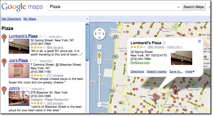
  • See Santa on a Google Map: On your home computer or laptop, visit www.noradsanta.org and choose your preferred language. You’ll see a large Google Map on the page displaying Santa’s current location and his next stop. Click the video icons to watch “Santa Cam” videos, and click the gift icons to learn more about each city.

  • Watch Santa fly with the Google Earth Plug-in: From www.noradsanta.org, click on the link Track Santa in Google Earth. You'll see Santa steering his sleigh right on the webpage. If you don't have the Google Earth plug-in, you can get ready by downloading it ahead of time.

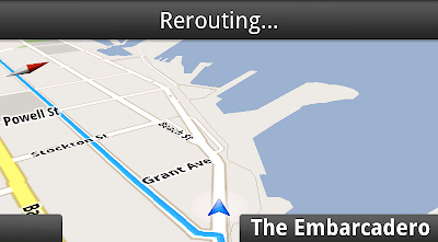
  • Follow Santa on your phone: Track Santa from your mobile phone by opening Google Maps for mobile and searching for [santa]. Or, visit m.noradsanta.org on your phone’s browser.

  • Subscribe to his YouTube channel: Santa’s home on YouTube is at http://www.youtube.com/noradtrackssanta. That’s where you can find videos from his journey throughout the night.

  • Get real-time information about Santa’s location: Use Google’s Realtime Search to get updates from social networks, news and micro-blogs like Twitter at @noradsanta, and keep up with news about his journey on this Facebook page.
For any techie questions you might have, we’ve also put together some helpful tips and tricks about all the cool ways you can experience Santa’s journey. Now that you know how to follow Saint Nick on Christmas Eve, it’s our tradition to tell the story of how this all started...

NORAD (North American Aerospace Defence Command) first began to track Santa in 1955 when a misprinted advertisement in a Sears & Roebuck catalogue mistakenly led callers expecting a Santa-hotline to the NORAD commander-in-chief's telephone. Embracing the spirit of the season, NORAD used its satellite and radar capabilities to offer callers sleigh-location updates, and has tracked Santa's whereabouts on Christmas Eve ever since. Then in 2004, Google started tracking Santa on Google Earth as a 20% project, which in 2007 grew into a partnership with NORAD, adding the mapping technology of Google Maps and Google Earth to the NORAD experience. Over the years, other Google teams have also joined in the holiday fun (YouTube, Google Voice’s www.SendACallFromSanta.com and Google SketchUp).

As we approach this year’s Christmas Eve adventure, Santa was able to take a break from the preparations to visit the New York Stock Exchange this past Monday. His helpful elves kept everything at the North Pole on schedule while folks from Google and NORAD attended the Closing Bell ceremony, and stood alongside Santa from Macy’s going over last minute details about tomorrow’s big ride.

Santa with NORAD, Google and members of the Marine Toys for Tots Foundation (that’s me, the tall guy in the back row clapping)

So don’t forget to visit www.noradsanta.org tomorrow morning starting at 2:00am EST when Santa embarks on his flight. From all of us here at Google, happy holidays and here’s to a very happy New Year!


Posted by Brian McClendon, Original Google Engineering Elf
Read More
Posted in Google Earth, Santa | No comments

Tuesday, 21 December 2010

Holiday trees in 3D

Posted on 15:55 by Unknown

Can you imagine the holidays without fir, spruce and cedar trees decorated with colorful ornaments? Beyond tracking Santa, we’re getting into the spirit of the season by placing 3D holiday trees in more than a dozen places on Google Earth 6.

Check out the Rockefeller Center in New York City. The only thing that would help make this scene even more festive would be crowds of people bearing shopping bags and a light dusting of winter snow! And don’t you just love how the ornaments on the New Year Tree in Moscow’s Red Square reflects the vibrant colors of Saint Basil's Cathedral?

Rockefeller Center


Red Square

One of the most interesting places where we’ve added holiday trees is Austin, Texas, along highway 360 near 2222. Every year when the holiday season starts, the cedar trees along this section of highway called Loop 360 are mysteriously dressed up in tinsel, ornaments and lights. Some say elves are responsible for spreading this holiday cheer, and we’re excited to celebrate and tribute the fun local activity with digital replicas of the trees!

In all, there are fourteen places where you can find holiday trees in Google Earth 6. Can you find them all?


Posted by Kay Chen, 3D Data Specialist
Read More
Posted in Google Earth | No comments

Tips for creating a free business listing in Google Places: business types

Posted on 08:35 by Unknown

Are you curious about what kind of businesses are eligible to appear in the free listings that appear on Google and Google Maps? In this second post in our blog series about how to create a clear and effective business listing via Google Places, we’ll help you to determine if Google Places is right for your business.

Business types and models that work with Google Places

Google Places is meant to facilitate customer interaction with brick-and-mortar businesses and service providers. Therefore, the business owner or employee who is officially authorized to represent their particular business location must have a physical address in order to comply with our quality guidelines.

Having a physical address means that your business has a specific location (typically including a street name and a street number), can be visited by potential customers or business partners, and has a specific phone number at that location where you can be reached during operating hours. Including your physical address in your free business listing helps customers figure out where they can find you.

Examples of business listings displayed on Google Maps


Businesses that aren’t right for Google Places

Here are a few examples of business types that are not currently eligible to use Google Places:
  • Web shops that operate exclusively online and have no office for visitor traffic or direct client interaction
  • Businesses without actual physical locations (your living room, the airfield where you offer paragliding lessons, nor the river where your rafting tours start do not qualify as business locations)
  • Companies with non-permanent locations like a farmers market stall, a mobile hot dog vendor, or a one-time concert event at a local café
  • Real estate companies that don’t have a central office and are trying to advertise individual apartments where no one can be reached in person or by phone
For operations like these, rather than appearing in Google and Google Maps search results associated with a physical location, other online tools might better fit your needs. One option is to advertise and generate awareness about your business activities through Google AdWords. This cost-effective program enables you to get the word out about your business, website or event via online ad campaigns, and does not require you to have a brick-and-mortar business address.

How to create a free listing if you’re eligible

If you’re a business with a physical office location that is open to customers and staffed both in person and via phone during regular business hours, we encourage you to create a free listing by signing in to Google Places here. For example, a real estate company with a corporate office can add the services it offers, the apartments it sells, and so on in the description field of the listing.


Be careful to create just one listing per physical location and to create listings only at places where your business is actually located. For example, if you run a DJ service and your office is at 41 Broadway in New York, you should only add that location in Google Places, even if you also DJ at 32 Main Street and at 14 Smith Street.

How to indicate service areas

For businesses that have one physical location but also offer their services elsewhere - such as the aforementioned businesses as well as locksmiths, translation services, delivery pizzerias, cleaning services and the like - you can use the Service Areas feature in your Google Places account. Marking a service area enables you to show your potential customers the range of places where you work.


Businesses that require travel to meet customers can define a radius around their main location or select specific areas they serve. If your main location is your home address and only used to receive business-related mail and phone calls, you can also hide that address and only show the service area in which you operate. This might be the case for babysitters, DJs, household services or IT repair services. Detailed instructions about how to set up this feature can be found in our help center.

Taxi and courier companies are particularly good examples for the use of the Service Areas feature. They offer a service that is location-independent and therefore shouldn't be associated with fixed locations on Google Maps. Even if you can find taxis often in front of train stations or airports, these are not locations owned by the business. The service area feature allows taxis to indicate the area in which they operate. If the taxis are coordinated over a dispatch centre, that can be listed as one physical location, otherwise the address should be hidden.

How to verify a listing

In order for your free business listing to appear on Google and Google Maps, you must verify your business via Google Places. This simple process includes providing a verification code by mail, automated call or text message. The phone number used for this process will be shown in your listing, so be sure that the number directs calls to your business.

We hope this information helps to explain our Google Places quality guidelines around setting up a free business listing. If you have any further questions about the types of businesses that are eligible for inclusion in Google Places, please visit our Google Places help forum.

Posted by Lina Paczensky, Local Search Quality
Read More
Posted in Google Places | No comments

Monday, 20 December 2010

Lunar Eclipse Live

Posted on 20:00 by Unknown

It'll be a dark and stormy night on the moon. Well, dark anyway, because tonight is the only total lunar eclipse of 2010.

Visible to people in North America starting at about 9pm Pacific this evening, the Earth will pass between the sun and moon, blocking the sun's light from reaching the moon's surface.

We’ve launched a live telescope feed in Google Sky, and we’ll be broadcasting the whole event so that you can keep tabs on the event regardless of the local weather conditions.

To find the feed, which we created in partnership with slooh.com, fire up Google Earth and enter Sky Mode by clicking on the Planet Icon in the toolbar and selecting Sky.


Then, open up the Current Sky Events folder and click on the blue Slooh Space Camera link to open the feed balloon.

Be sure to check back after the eclipse too and follow along as we and Slooh broadcast more live images from their telescopes.

Posted by Noel Gorelick, Chief Extraterrestrial Observer
Read More
Posted in | No comments

Friday, 17 December 2010

Imagery Update - Week of December 12th

Posted on 15:35 by Unknown


‘Tis the season of giving! For those of you who’d like nothing more than to receive the gift of new places to explore on Google Earth and Maps, you’re in luck. Our imagery team’s latest update includes many places that relate metaphorically to the holiday season.

For example, it’s often at the end of the year that we remark “Out with the old, and in with the new.” That concept can also be applied to the below image that captures two military installations located North West of Beijing. You can see the fascinating juxtaposition of the modern Yongning Air Force base (bottom right) and an adjacent section of the ancient Great Wall of China (upper left quadrant) that outlines parts of the Shibapan Ling mountain range. And yes, you really can see the wall from space!

Near Beijing, China

Wouldn’t gold make a great stocking stuffer? Take a look at the below image of Jin Xixin Lake, the dammed section of the Minjiang River also known as the Gold Lake, located south of Mount Wuyi, China. In this image, you can see lots of prime locations that might make great prospecting camps. Get out your pans!

Gold (but no frankincense) near Mount Wuyi, China

Finally, although this time of year is often associated with the Christian-based holidays, when thinking about China, thoughts naturally turn to Buddhism. Just the other day on the Google campus in Mountain View, a group of Tibetan monks visited to build a Sand Mandala and lead a meditation group. In this spirit, I’ve included the below image of the first Buddhist monastery built in Tibet, the Samye Monastery.

A site of enlightenment in Tibet

The examples above only hint at the type and breadth of features that can be seen and discovered in our latest batch of published imagery. Happy exploring and happy holidays!

High resolution aerial updates:
USA: Birmingham AL, Little Rock AK, Peoria IL, Tuscaloosa AL, Worcester MA, Jerome ID, Stevenson WA, Knoxville TN, Morganton NC, and Statesville NC
Canada: Powell River, and Sunshine Coast, BC., Canmore, and Cold Lake
Netherlands: Hilversum
South Africa: Northern, Eastern, and Western Cape, and Limpopo
Sweden: Gävleborgs Län, Jönköpings Län, Uppsala Län, Västerbottens Län, and Västra Götalands Län

Countries receiving high resolution satellite updates:
Albania, Algeria, Angola, Argentina, Armenia, Australia, Austria, Azerbaijan, Bahrain, Bangladesh, Belgium, Bhutan, Bolivia, Bosnia and Herzegovina, Botswana, Brazil, British Virgin Islands, Brunei Darussalam, Bulgaria, Burkina Faso, Cambodia, Cameroon, Canada, Chad, Chile, China, Colombia, Costa Rica, Croatia, Cuba, Democratic People's Republic of Korea, Democratic Republic of the Congo, Denmark, Dominican Republic, Ecuador, El Salvador, Estonia, Ethiopia, Finland, France, Georgia, Germany, Greece, Guatemala, Haiti, Honduras, Hungary, India, Indonesia, Iran, Ireland, Israel, Italy, Japan, Jordan, Kazakhstan, Kenya, Kuwait, Kyrgyzstan, Laos, Latvia, Lesotho, Liberia, Libya, Lithuania, Luxembourg, Madagascar, Malawi, Malaysia, Mali, Mauritania, Mexico, Mongolia, Montenegro, Morocco, Mozambique, Myanmar, Namibia, Nepal, Netherlands, New Caledonia, New Zealand, Nigeria, Norway, Oman, Pakistan, Panama, Papua New Guinea, Paraguay, Peru, Philippines, Poland, Portugal, Puerto Rico, Republic of Korea, Romania, Russia, Samoa, Saudi Arabia, Senegal, Serbia, Slovakia, Slovenia, Solomon Islands, South Africa, Spain, Sri Lanka, Sudan, Sweden, Switzerland, Syria, Taiwan, Tajikistan, Tanzania, Thailand, Turkey, Turkmenistan, Uganda, Ukraine, United Arab Emirates, United Kingdom, United States, Uruguay, Uzbekistan, Venezuela, Vietnam, Virgin Islands, West Bank, Yemen, Zambia, Zimbabwe

These updates are currently only available in Google Earth, but they'll also be in Google Maps soon. To get a complete picture of where we updated imagery, download this KML for viewing in Google Earth.

Posted by Eric Kolb, Geo Data Strategist
Read More
Posted in imagery | No comments

Under the hood of Google Maps 5.0 for Android

Posted on 12:45 by Unknown
[Cross-posted from the Official Google Blog]

Yesterday we introduced Google Maps 5.0 for Android with two significant new features: 3D interaction and offline reliability. In order to create these features, we rebuilt Maps using vector graphics to dynamically draw the map as you use it. Building a vector graphics engine capable of achieving the visual quality and performance level you expect from Google Maps was a major technical challenge and enables all sorts of future possibilities. So we wanted to give you a closer look under the hood at the technology driving the next generation of mobile maps.

Vector graphics
Before diving into how Maps uses vector graphics, it may be helpful to understand how maps were created before. Previously, Google Maps downloaded the map as sets of individual 256x256 pixel “image tiles.” Each pre-rendered image tile was downloaded with its own section of map imagery, roads, labels and other features baked right in. Google Maps would download each tile as you needed it and then stitch sets together to form the map you see. It takes more than 360 billion tiles to cover the whole world at 20 zoom levels!

Now, we use vector graphics to dynamically draw the map. Maps will download “vector tiles” that describe the underlying geometry of the map. You can think of them as the blueprints needed to draw a map, instead of static map images. Because you only need to download the blueprints, the amount of data needed to draw maps from vector tiles is drastically less than when downloading pre-rendered image tiles. Google Maps isn’t the first mobile app to use vector graphics—in fact, Google Earth and our Navigation (Beta) feature do already. But a combination of modern device hardware and innovative engineering allow us to stream vector tiles efficiently and render them smoothly, while maintaining the speed and readability we require in Google Maps. Just try it out and see for yourself!

See the difference between image tiles (left) and vector tiles (right) tilted to show 3D buildings.

One map, many perspectives
Using vector tiles instead of image tiles gives Maps the flexibility to re-draw the same map from different perspectives using the same set of data. Zooming is one example of this at work. If you magnify an map image tile by 2x, lines such as roads and text would get twice as wide and appear blurry. As a result, we had to constrain Maps to 20 fixed “zoom levels,” each one twice as close as the last. Every time you zoomed in further, you’d need to download a completely new set of image tiles. It took time to load new data over a mobile data connection, and would fail when you lost your connection in a subway or large building.

Compared to image tiles (left), vector tiles (right) keep lines and labels crisp as you zoom.

With vector graphics, you no longer need to “round” to the nearest zoom level and then download all the tiles for that level. One vector tile has the underlying vector data (or blueprints) to draw the map at many different levels of scale. So when you zoom, the map stops when your fingers stop, and roads and labels always stay crisp. This same technique powers the new 3D map interactions: tilt, rotate and compass mode. Just like with zooming, Maps uses the same vector data to draw the map from any angle or direction as you tilt or rotate.

We can also display entirely new levels of detail that weren’t possible with flat image tiles. For example, in the 100+ cities where we have 3D building data, each building is drawn in 3D using a polygonal building footprint and heights for different parts of the building. And with tilt and rotate, you can see them from a variety of different angles.

Reading the map
Just like other map features, labels are dynamically drawn so they continue to face you and stay legible if you rotate the rest of the map or use compass mode. Maps also “chooses” the best labels to show you based on several factors. You’ll notice labels fade in and out as you interact with the map so that the most useful ones appear and the map never gets too cluttered.

See the difference between rotating maps with static labels (left) and dynamic labels (right).

Vector graphics also allow us to draw additional data on the map more clearly. For example, traffic or transit lines no longer block the labels beneath them. We can also draw the same map in different styles—like “satellite view” where the roads are translucent over aerial imagery, or Navigation’s “night mode” where a darker palette helps your eyes adjust quickly in the lower light.

Previously, map features like labels and traffic could conflict (left) instead of blend seamlessly (right).

Offline reliability
Vector graphics also enable another significant new feature: the ability to continue viewing maps even when you have poor—or no—network connections. Because each vector tile works across multiple zoom levels, it requires more than 100 times less data to view maps across all zoom levels than before, allowing Maps to cache much larger areas of the map on your device.

With this first version, Maps proactively caches map data for the places you use Maps the most—where you’re actively using it as well as places for which you search or get directions. Then when you’re plugged in and connected over WiFi, caching happens automatically. Near your frequent places, you’ll get detailed vector tiles for city-sized regions so you can see every road labeled. Further away, you’ll have less detail but will typically have towns and highways labeled for miles. We’re continuing to work on these algorithms, so you’ll see improvements over time.

Offline rerouting
With Google Maps Navigation (Beta), you’ll also see the benefits of additional caching with offline rerouting. This feature is only possible because Navigation caches not only map data but also data like turn restrictions for the areas surrounding your route. You’ll still need to be connected when you first start a trip to download and cache your route. But this way, even if you take a wrong turn after losing your connection, Navigation can use the cached data to get you back on your way. We will be rolling this feature out gradually over the next few weeks.

This is just the start, and we’re really excited about all the possible ways to use vector graphics technology for the next generation of Google Maps. So please stay tuned!

Posted by Andrew Miller, Software Engineer, Google Maps for mobile
Read More
Posted in 3D, imagery, Mobile | No comments

Thursday, 16 December 2010

The “City of Love,” now in 3D

Posted on 13:55 by Unknown
[Cross-posted from the Google SketchUp Blog]

To foreigners, Paris is the “city of love.” To Parisians, it’s the “city of lights” (La Ville-Lumière). Today, Paris is the “city in 3D.”

Sunrise in Paris

Often considered one of the top destinations for world travelers, Paris is known for landmarks like the Notre Dame Cathedral and the Arc de Triomphe, world-famous museums like the Louvre and the Musée d'Orsay, and hundreds of little bistros with French pastries so good they make your heart pop (literally and figuratively). Now all of these sites – and the many, many others that make Paris special – are available to tour in 3D in Google Earth.


With Google Earth’s “3D Buildings” layer turned on (or by using the Google Earth plug-in for Google Maps) you can wander the streets of the Montmartre district made famous by artists like Picasso, Van Gogh and Dalí from your living room. You can also see the Sacré-Cœur Basilica without having to climb the 237 steps to get there. Instead of waiting in line to see the view from the Eiffel tower, fly straight to the top in Google Earth and get a 360-degree view of Paris. Round out your tour by taking a peek at the Centre Pompidou, which turned the architectural world upside down (or perhaps inside out?) with its exposed skeleton and brightly colored building utilities.

Whether you’re an armchair tourist or planning your next vacation to France, take some time to tour the streets of the French capital and see the historic sites; after all, many of them were created by modelers just like you.

If you’d like to get involved in modeling your town (or any other location), we have several tools to get you started. With Google Building Maker, you can create and contribute a building in as little as 10 minutes. And if you’d like to refine your building, bring it into Google SketchUp for fine-tuning.

Happy touring!

Posted by Gopal Shah, Google SketchUp team

Read More
Posted in 3D, SketchUp | No comments

Send a message of holiday cheer with Google Maps

Posted on 10:20 by Unknown
[Cross-posted from the Official Google Blog]

For me, celebrating the holidays is about spending time with family and friends. Along with sharing delicious meals and building snowmen in the backyard, getting into the season often means traveling to places both familiar and new, whether going to visit family or walking down the Champs-Élysées to see the holiday lights.

We’re sure many of you have holiday plans in the works, so we’ve designed greeting cards you can email to friends and family—to share those fun adventures or just to say hello from wherever you are around the world. In addition to choosing from 10 holiday covers and adding a personal message, you can include specific directions, a Street View image or a favorite place on the inside of the card.

Since I grew up in New England, the holidays always make me think of skiing. So I’ll send some of my friends cards with inspiring ski scenes in Street View, or directions to Squaw Valley for an upcoming ski trip.


Around this time of year, I also get nostalgic about specific places where great holiday memories were made, so the card I’ll send to my family will remind them of the amazing breakfasts we had at Lou’s during past holiday seasons. And the card to my friends in New York will suggest a restaurant we should try when I visit them in a couple of weeks.

Thanks to Christoph Niemann for inspiration

And of course, to share some winter weather with my friends in California, I’ll send a card with some wintry scenes of Antarctica and Whistler, and snowy greetings on the cover.


We hope these online cards help you stay connected and share holiday cheer with your loved ones, whether you send directions to a holiday party, winter imagery from Street View or the various places that signify the spirit of the season to you. Start sending at googlemapsholidays.appspot.com. Happy holidays!

Posted by Katie Mandel, Product Marketing Manager, Google Maps
Read More
Posted in | No comments

The next generation of mobile maps

Posted on 09:45 by Unknown
[Cross-posted from the Official Google Blog and Google Mobile Blog]

I’m excited to announce Google Maps 5.0 for Android, with two significant new features: 3D interaction and offline reliability.

We launched Google Maps for mobile a little more than five years ago. Since then, we’ve added dozens of features, and we’ve grown from a few thousand to more than 100 million users. Still, a couple of things have remained the same: a flat, north-up map and the need for a strong Internet connection. Today, we’re changing that for the first time.

Tilt while zoomed in (left) or use compass mode (right) to orient yourself with 3D buildings.

Explore maps in 3D
Until now, Google Maps has always downloaded the map as a set of small, square images that we stitch together to form the map you see. (You’ve probably seen those gray squares getting filled in, block-by-block, as the images load over the network.) Starting today, we’ll use vector graphics to dynamically draw the map on your device as you use it, allowing you to interact with it in new ways:
  • Tilting: Drag down with two fingers to tilt the map. Tilt while zoomed in on one of the 100+ cities around the world with 3D buildings to see a skyline spring to life.
  • Rotating: Twist with two fingers to rotate the map. After tilting to see 3D buildings, rotate around them to gain a new perspective from any direction.
  • Smooth zooming: Slide two fingers together or apart, and see the map and labels continuously scale to any zoom level, stopping when your fingers stop.
  • Compass mode: Center the map on your location, and then tap the compass button in the top right corner. The map will flip into 3D mode and start rotating to match your perspective, while still keeping all the labels upright and readable.
I found 3D buildings especially useful on a recent trip to New York. From my hotel to the Google office in Chelsea and bars on the Lower East Side, this richer representation of the real world made the map much more helpful. And whenever I walked out of a building or subway station, I used compass mode to get myself quickly oriented and on my way. Check out the video below to see tilt, rotation, zoom and compass mode in action, or see more pictures.


Offline reliability
Google Maps has always been, and continues to be, a fundamentally Internet-connected experience, meaning you always get the freshest map and place data, search and voice search, live traffic conditions, satellite and Street View imagery, and much more. Still, we understand that mobile Internet connections aren’t 100% reliable. So today we’re happy to take the first steps toward greater offline reliability, so you can find your way even if you lose your connection.

In the past, you’ve probably had frustrating moments when you get stranded without a map, whether ducking into the subway, sitting at the back of a restaurant or traveling anywhere with a flaky Internet connection. But dynamically drawing maps requires 100 times less data to get maps across all zoom levels, so now we’re able to proactively cache (or store) large areas on your device based on where you use Maps the most. This way, you can rely on having fast, robust maps available to you where you’re most likely to need them.

For example, I live in San Francisco and work in Mountain View, so Maps makes sure I can always pull up detailed street maps of each city and area maps for the whole San Francisco Bay Area. When I do have an Internet connection, I still get live traffic, imagery, richer map details and all the other features I’m used to with Google Maps.

Rather than having a static set of maps when installed, Maps will automatically start caching the areas you visit the most when your device is plugged in and connected to WiFi (e.g., the nightly charge). We’re already hard at work improving the algorithms and technology behind these features, so over time you can expect to see maps work better in more offline situations.

Offline rerouting
If you’re one of the more than 10 million people relying on Google Maps Navigation (Beta), our free turn-by-turn GPS navigation feature, losing your Internet connection can be particularly painful. (This happened to me on a recent ski trip to Tahoe, and I was left trying to manually find my way back to my route.) So we’re also introducing offline rerouting. You’ll still need a connection to start a route, but if you miss a turn along the way, we’ll quickly get you back on track, even if you don’t have an Internet connection. We’ll be rolling this feature out gradually over the next few weeks.

Google Maps Navigation now automatically reroutes you, even if you lose your connection.

These new features are just the first steps in maximizing dynamic map drawing technology to create a faster, more interactive experience where efficiency really matters: mobile devices. For example, we estimate that viewing maps now requires almost 70% less mobile network data overall than before. We can’t wait to take the next steps in making Google Maps faster, more reliable and even more useful no matter where you take it.

Get Google Maps for mobile 5.0 by searching for Google Maps in Android Market (or tap on this link if you’re on your phone). Android 1.6+ devices can get Maps 5.0, but 3D and offline features require Android 2.0+, and some features may not be supported for all devices or countries.

So try it out. Wander around in compass mode, explore 3D buildings—even dare to open Maps on the subway! I hope you enjoy all the new features as much as we do.

Posted by Michael Siliski, Product Manager
Read More
Posted in 3D, googlenew, imagery, Mobile | No comments

Wednesday, 15 December 2010

Announcing Google Earth Enterprise 4.1

Posted on 12:00 by Unknown
[Cross-posted from the Enterprise Blog]

Back in August we announced Google Earth Enterprise 4.0. This version introduced the new Google Earth Portable Solution, and a Google Earth Android Client, for enterprise use. Since then, we’ve been speaking with numerous customers about the release, learning all about the compelling ways they’re using our portable and mobile technologies and listening to their helpful feedback. We’ve made additional developments based on that feedback, and today we’re pleased to announce an update to Google Earth Enterprise (GEE). The new version 4.1 brings with it:
  • 2D Map Cutting and 2D Map Portable Serving: Google Earth now supports cutting and serving 2D (Mercator) maps.
  • Google Maps API V3 on Google Earth Enterprise Solution: Developers can now use the Maps API V3 to build and serve mapping applications.
  • Customized search services for Google Earth: Search tabs on the portable server can be extended via Python search scripts that you bundle with the server for distribution.
Thanks again to all our customers and partners who provided us with great feedback over the past few months and we look forward to hearing more from you.

Posted by Dylan Lorimer, Enterprise Earth/Maps Product Manager

Read More
Posted in Google Earth | No comments

Tuesday, 14 December 2010

Building Maker: 109 cities and counting

Posted on 17:20 by Unknown
[Cross-posted from the Google SketchUp Blog]

Today’s Google Building Maker imagery update is our last one for 2010 – you can now use our purpose-built geo-modeling tool in any of 109 cities around the world. We’ve just released imagery for:
  • Oklahoma City, Oklahoma
  • Oslo, Norway
  • The Hague, The Netherlands
San Antonio, Texas is one of the newest additions to Building Maker.

We also greatly expanded the coverage areas for San Diego, California and Portland, Oregon. And in case you missed the update two weeks ago, we also released imagery for:

  • San Antonio, Texas
  • Tucson, Arizona
  • Norfolk, Virginia
  • Salt Lake City, Utah
Norfolk, Virginia is itchin' to be modeled.

Still waiting for your city to be added to Building Maker? You can request it; in the meantime, try modeling in one of these new cities to help get them on the 3D map.

Posted by Nicole Drobeck, Geo Community Program Manager

Read More
Posted in 3D, SketchUp | No comments

Deep sea exploration with the joint Indonesia-USA Ocean Expedition

Posted on 10:05 by Unknown

Come on a tour to never-before explored Indonesian waters. The INDEX-SATAL 2010 Expedition is the first-ever joint ocean research voyage by the Republic of Indonesian and the United States. To experience it yourself, watch a Google Earth YouTube video tour here or explore the area more interactively with the Google Earth plug-in on our Ocean Showcase.


The colored surface areas seen in the video represent underwater terrain data collected during the expedition. The data, highlight photos and videos have been incorporated into Google Earth so you can now explore them on your own by diving under the surface.

Much of the Coral Triangle remains unexplored, and this partnership aims to help reverse the decline of coral reefs in the area and to protect natural resources. The expedition began in the SATAL region around two island chains stretching north of Sulawesi. It was undertaken by scientists from the USA National Oceanic and Atmospheric Administration, Indonesia’s Ministry of Marine Affairs and Fisheries, and the Indonesian Agency for the Assessment and Application of Technology.

“Telepresence” was used to send data in real time to scientists who stood watch at Exploration Command Centers in Jakarta and Seattle. This same technology brought the excitement of the expedition to visitors at the Exploratorium in San Francisco as well.

Little Hercules, a remotely operated exploration vehicle, descended 6000 feet under the sea to capture images and videos of exciting sights like hydrothermal vents and creatures like the deep sea octopus seen below:


Mapping and discovery data from expeditions like this will help all organizations involved better understand ocean resources and how to protect them. More information about the still mysterious ocean will ultimately further economic and environmental initiatives such as the management of sustainable fisheries, the conservation of the marine environment and the preservation of fragile corals.

Dive deeper at Oceanexplorer.noaa.gov, or download this KML for viewing in Google Earth.

By Jenifer Austin Foulkes, Product Manager, Ocean in Google Earth and Maps

Read More
Posted in Google Earth, ocean | No comments

Monday, 13 December 2010

Introducing the Google Latitude app for iPhone

Posted on 18:05 by Unknown

[Cross-posted from the Google Mobile Blog]

“Where are you?”


Starting today, you’ll never again have to answer (or ask) that question when you’re on the go with your iPhone. With the new Google Latitude app for iPhone, you can see where your friends are and now, continuously share where you are – even in the background once you’ve closed the app.


Since launching last year, Latitude’s focus has always been on one goal: make it simple to stay in touch with friends and family by sharing where you are with each other. Simple setup. Simple sharing without fumbling for your phone. Now, you can use Latitude on your iPhone just like the more than 9 million people actively using it from Android, BlackBerry, Symbian, and Windows Mobile smartphones. Use the app to:
  • See where your friends are
  • Share your location continuously with whomever you choose
  • Contact friends by phone, text message, or email
  • Control your location and privacy


Watch the Latitude app for iPhone in action

You still get simple control over your privacy. Remember, Latitude is 100% opt-in. You must install the app and add friends (or accept requests) to start sharing your location. You can turn off background updating if you’d like and control the same privacy settings: share only city-level location, hide your location, or sign out of Latitude at any time. Learn more in the privacy tips video.

Though we released Latitude as a web application before the iPhone supported third party background applications, today’s Latitude app was built from the ground up using iOS 4’s new multitasking capability to support background updating. You’ll need iOS 4 and above on an iPhone 3GS or iPhone 4 to use the app.

Download Google Latitude now from the App Store in over 15 languages and 45 countries. It will be appearing in the App Store over the next day, but you can also find it directly now. Learn more in the Help Center or ask questions in the Help Forum.

Posted by Chris Lambert, Software Engineer, Google Latitude Team

Read More
Posted in | No comments

Directions, the way you want them

Posted on 13:40 by Unknown

We recently released advanced options for getting public transit directions on Google Maps, helping you customize your route based on your personal preferences.

We work hard to provide the right results to get from A to B, but sometimes riders have their own preferences. For example, you might not mind a longer journey if it means fewer transfers; or you may prefer traveling by bus or train, rather than subway, to have views of your route. You can now specify these preferences and alter your route results by clicking the “Show options” link below your destination:


We hope that this new feature makes it easier for you to find your way! To get started, please visit maps.google.com/transit.

Posted by Noam Ben-Haim, Product Manager
Read More
Posted in directions, Transit | No comments

How to find directions online (and 50 other things you might want to teach your parents)

Posted on 09:35 by Unknown

Everything really is bigger in Texas, as my parents found out when they moved to Houston from Kansas in early November. Since moving, my mom - who openly admits that navigation isn’t her strongest suit - was getting lost quite often as she settled into her new hometown. She found herself spending just as much time trying to find the grocery store as doing the actual shopping. So when I headed home for Thanksgiving, I gave her a quick lesson on how easy it is to find directions online using Google Maps.

With millions of people travelling across county and state lines for the holidays, my mom probably isn’t the only one who could use a quick tutorial on how to get simple, easy to understand, and accurate turn-by-turn directions.

That’s why a bunch of Googlers got together to create a website - TeachParentsTech.org - that enables kids to send basic how-to videos to mom, dad, or even grandma. Check out this video in which I show just how easy it is to get from Point A to Point B with the help of Google Maps.


To see more videos, or to send someone a tech support care package of your own, make sure to visit TeachParentsTech.org.

Posted by Preston Hershorn, Product Marketing Manager
Read More
Posted in directions, education | No comments

Thursday, 9 December 2010

Trailblazing in Portland

Posted on 15:00 by Unknown
[Cross-posted from the Hotpot Community Blog]

When we announced the availability of Hotpot last month, we knew from the beginning we were going to take a different approach to marketing the product and engaging with our users, both businesses and consumers.

To that end, we’re excited today to start testing this new approach by launching our first local marketing campaign in Portland, Oregon. Portland is a tech savvy, forward-thinking city with a history of innovation and some of the best coffee houses, microbreweries and parks in the country. Whether you know it as The City of Roses, Stumptown, P-Town, Rip City or just PDX, Portland’s thriving local business community and strong heritage of being a trailblazer made it a great choice for us to try something new.

So starting today and over the course of the next few months, we’ll be out and about in Portland. Here’s a taste of what’s in store:

Business Kits and Window Decals


Every day millions of people search on Google.com to find local businesses, and we want to make it seamless for standout businesses to get discovered online. To achieve this, we’ll be working directly with some of Portland’s top businesses to educate them about Google Places for business and all its benefits. In addition, to help these businesses spread the word, we’re providing owners with special Google Places Business Kits. These kits are a multi-flavored sampler of marketing materials that can help businesses get even more exposure, get them rated and reviewed online, and get more customers through their door. We’re already distributing these to some of Portland’s top businesses, but any business in Portland who has claimed their Place page can request a box.


A central part of the kit is the bright red “Recommended on Google” window sticker. This is not your ordinary sticker. Unlike others, this is an interactive sticker that has Near Field Communications (NFC) technology built right in, allowing people with cutting edge phones like the Nexus S to simply touch their phones to the sticker to find out more information about the business. Suddenly stickers are cool again!

Community Events


Sure, Hotpot’s about sharing recommendations with friends online. But we thought it’d be fun to take things offline. To kick things off, we’re partnering with Portland’s beloved Voodoo Doughnut. Because we at Google are such big fans of their tasty treats, we wanted to spread the love — so if you like doughnuts and coffee, be sure to stop by both locations starting this Saturday at 10am for a special treat.

Hotpot Jackpot


We’re also launching our second Hotpot Jackpot competition to encourage Portlanders to start rating the places they know and share them with friends and family. Everyone over the age of 18 who lives within a 50-mile radius of Portland can participate, and the top five raters at the end of the competition will win dinner for 10 at any restaurant in Portland, courtesy of Google. To kick things off, all of the fans at tonight’s Trail Blazers vs. Magic game will receive t-shirts announcing the competition and supporting the Blazers.

This is just the beginning and we’ll be doing a lot more in the upcoming months. For the latest and greatest of what we’re up to in Portland (and elsewhere), keep an eye out by staying up to date via the Hotpot Blog, and by following us on Twitter and liking us on Facebook.

Posted by Bernardo Hernandez, Director of Emerging Marketing
Read More
Posted in Google Places, Hotpot | No comments

Wednesday, 8 December 2010

Street View in Romania

Posted on 09:30 by Unknown

Bram Stoker’s world famous novel Dracula was believed to have been inspired by fifteenth century Wallachian Prince, Vlad Dracul from Romania (better known to many as Vlad the Impaler). The legend of the vampire is still deeply rooted in Transylvanian culture today, and tourists from across the world come to explore the history and mystery of the many beautiful castles that can be found here.

But of course those aren’t all the sights Romania has to offer, and now you can see for yourself, because today we’re making 360-degree Street View imagery available in Romania for several cities and roads.

From your virtual vantage point, you can now take a look over the bridge onto Lacul Vidraru (Vidraru Lake). This is the starting point of the most beautiful road in Romania, the Transfăgărășan mountain pass, which at its highest point reaches 2,034 meters above sea level:


Or check out the summer residence of Romanian Kings, Castelul Peleș (Peleș Castle):


It’s not just Paris that has an Arc de Triomphe. You can whizz round the Romanian
Arcul de Triumf in the capital Bucharest:


And here’s our parliamentary palace, Palatul Parlamentului (Parliament Palace):


There’s heaps to explore but I’ll leave you with one final tip, and that’s to visit
Vatra Ardealului, my favorite cofee shop in Brasov, which you can see below:


Welcome to Romania and enjoy your virtual exploration!

Posted by Octavian Iercan, Operations Lead, Street View Europe
Read More
Posted in imagery, Street View | No comments

Monday, 6 December 2010

Cricket Season Has Begun!

Posted on 10:50 by Unknown

Summer has arrived in the southern hemisphere, which in Australia, means cricket!

“The Ashes,” a tournament series played between England and Australia, recently began a couple weeks ago so the competition is underway. It’s said to be international cricket's most celebrated rivalry, dating back to 1882.

The series is played biennially, alternating between the United Kingdom and Australia. Since cricket is a summer sport, and the venues are located in opposite hemispheres, the break between series alternates between 18 and 30 months.


In Australia, where the tournament is being played this year, the “grounds” (stadiums) used are "The Gabba" in Brisbane, the Adelaide Oval, the WACA in Perth, the Melbourne Cricket Ground (MCG) and the Sydney Cricket Ground (SCG), in that order.

A view of the Sydney Cricket Ground in Google Earth

So whether you’re a cricket newbie like me, or a veteran “cricketer,” we hope that you’ll explore all of these grounds in Google Earth, or just enjoy our video tour, today!

Posted by Bruce Polderman, Product Manager
Read More
Posted in 3D, Google Earth | No comments

Friday, 3 December 2010

Rediscover Historical Imagery in Google Earth 6

Posted on 13:35 by Unknown

Historical imagery is one of the most powerful features of Google Earth, enabling you to go back in time and browse the visual historical record of our planet - from the evolution and rise of developing communities to the destruction caused by hurricanes, earthquakes and fires. With Google Earth 6, we’ve made it easier than ever to discover historical imagery. In addition to streamlining the timeline interface, we’ve added a date button to the status bar to notify you of past imagery that you might be interested in exploring. So now, when you zoom in on a location in our latest version of Google Earth, the button will appear highlighting specific years. Clicking it enables historical imagery and takes you back to the year you selected. For instance, when I zoom in on the headquarters of a certain company with a fruit namesake nestled in the heart of Silicon Valley, Google Earth suggests imagery from 1948. Clicking the date button reveals the fruit tree orchards that used to inhabit that very location. I wonder if they were apple trees.

Google Earth 6 suggests historical imagery to explore, e.g. of Silicon Valley in 1948

In the almost two years that historical imagery has been available, we have captured several moments of cultural significance, such as the inauguration of the first African American President of the United States, the devastation of Hurricane Katrina, and the transformation of South Africa in preparation for the 2010 FIFA World Cup.

Washington D.C., January 20, 2009. Can you spot where the jumbotrons were installed?

But the feature is more than just what historians deem significant. We built the historical imagery database to enable anyone to see and tell their own personal history. A great example comes from fellow historical imagery engineer Reuel Nash:

In 1979, my wife and I spent the first night of our marriage in a hotel at Dallas/Fort Worth International Airport. It was still there in 1995, which you can see in Google Earth. The hotel and the surrounding area has since been replaced by Terminal D. You can see the terminal construction (and destruction of the hotel) literally from the ground up using historical imagery.

The construction of Terminal D at Dallas/Fort Worth International Airport

We have a vast amount of data in our historical imagery archive, so you’ll be able to tell your own personal stories by browsing those places that are special to you. In fact, we have more square miles of high resolution imagery in our historical imagery archive than in our default view. In the coming years, we look forward to expanding this imagery collection even further. Visit the Historical Imagery Showcase to watch video tours of cities with imagery dating as far back as 1940.


Posted by Chris Co, Google Earth Software Engineer
Read More
Posted in Google Earth, imagery | No comments

How Local Search Ranking Works

Posted on 09:05 by Unknown

We’ve been quite busy this year working on Google Places, Tags, Boost, and our shiny new addition: Hotpot. With so many different products and features now available for local businesses, we wanted to take a step back and explain how the ranking of local listings works when people search on Google and Google Maps.

Product Manager Jeremy Sussman takes us under the hood in this informative video. Below are a few key takeaways, but we encourage you to watch the video, which features helpful examples and visuals.


Local search ranking refers to the placement and order of local information on a Google or Google Maps organic search results page. There are a variety of factors we take into account to provide you with results that match your local search, and three of the primary signals are relevance, prominence and distance. The best way to help potential customers connect with your business is to ensure that your basic company information like its name, address and phone number, are accurate, and then to add rich details like photos, hours of operation and more. You can do this by claiming and verifying your business via Google Places. However, claimed business listings do not receive any special ranking treatment over unclaimed business listings.

Google Tags and Boost are great online advertising solutions for local businesses. Tags make your organic business listings stand out on the Google and Google Maps search results page with a bright yellow marker that highlights specific attributes such as offers, videos or photos. And Boost is an effective complement to your organic Places listing because it quickly and easily creates an ad that can appear alongside the search results - giving your business additional exposure to people searching online. Neither of these advertising products available through your Google Places account affect the organic ranking of your business listing on Google or Google Maps.

Conversely, Hotpot - our new local recommendation engine based on ratings from you and your friends - can definitely affect the ranking of the local businesses you see in your organic search results. If you’re signed in to your Google account and have enabled Hotpot, you’ll get personalized recommendations based on the ratings you and your friends provided - making it easier for you to discover new places you’ll enjoy.

Posted by Brianna Brekke, Senior Strategist, Google Places
Read More
Posted in Boost, Google Places, Hotpot, Tags | No comments

Thursday, 2 December 2010

Mapping Korogocho

Posted on 17:15 by Unknown
[Cross-posted from the Google Africa Blog]

At Google we want to make the world's information more accessible and useful to people all over the globe. This includes providing rich local geographic data because a high percentage of search queries have a geographic component. We have often spoken about Google Map Maker, a tool that allows people to help create a map by adding or editing features such as roads, businesses, parks, schools and more.

We are ever grateful to Kenya’s active online cartographers who have helped us build our maps from the ground up. Maps are valuable for users, governments, NGOs, universities and entrepreneurs alike, who can visualise, plan and market the areas and projects that they work on. The mapping session we held recently with 21 volunteers in Korogocho, one of the largest slum neighbourhoods in Nairobi, is one such example of cartographers literally putting their community on the map. We joined forces with Internews and a group of inspiring volunteers from the Korogocho community to build their very own maps.

Ahmed Abdi of Korogocho receives a certificate from Jacqueline Rajuai on completion of the mapping exercise

We only had two and a half days to achieve this task but the group was up to the challenge! After 2 hours of hands-on training on the mapping tools, we embarked on mapping Korogocho and, thanks to the amazing hardworking volunteers from the area, they have now added all sorts of rich information about Korogocho on Google Maps (Map Maker). See below for ‘before’ and ‘after’!

Korogocho before the mapping session


Korogocho after the volunteers mapped the area on Google Map Maker

During this productive mapping exercise, the group mapped social and health infrastructure that is important to their community, including water vendors, public toilets, bio-gas projects, schools, Adopt-a-Light locations and more.

This is the beginning of bigger things that Internews has in store for the area, and we are grateful that they approached us to help them take that first step towards an impressive new map of an important part of Nairobi. We are pleased to continually improve our maps functionality for Africa, and helping to make Africa's information readily available.

Posted by Jackie Rajuai, GIS Specialist, Google Kenya
Read More
Posted in Map Maker | No comments
Newer Posts Home
Subscribe to: Posts (Atom)

Popular Posts

  • Take off for the holidays with Google Street View
    Whether it’s touring the canals of Venice , swimming with the seals in the Galapagos or climbing the Burj Khalifa in Dubai, Street View ha...
  • A bird’s eye view of The Queen’s Diamond Jubilee procession
    Following the royal wedding in 2011, the eyes of the world will again be on London as we celebrate the Diamond Jubilee of Queen Elizabeth I...
  • New Maps domains in 11 countries in Middle East & North Africa
    [Cross-posted from the Google Arabia Blog - in Arabic] With the growing numbers of Internet users in the region, we noticed that a huge num...
  • Apply now to be the next Google Maps Trekker
    We’re working to build the very best map of the world, and we’d love your help to do it. Today we’re kicking off a pilot program that enable...
  • See the seafloor like never before on World Oceans Day
    Only a tiny fraction of our oceans have ever been explored. As a matter of fact, we know more about the surfaces of Mars and the Moon than w...
  • Get a better view of natural geography with Google Maps
    When you look at Google Maps, we want you to see the most comprehensive, accurate and easy-to-understand representation of the entire world....
  • Help improve the “blue dot” for people visiting your venue
    When we announced the availability of indoor maps for Android last November , we also introduced Google Maps Floor Plans as a tool for busi...
  • Refocused Design Evolution, Continued
    In June we launched the start of a comprehensive visual redesign for Google Maps founded on three key principles: focus, elasticity, and ef...
  • Google Map Maker now available in South Africa and Egypt, and coming soon to more corners of the globe
    From the wild grasslands of Kruger National Park to the the extraordinary pyramids of Giza, the world is ripe with wonders waiting to be exp...
  • Visit the Hiroshima Peace Memorial in Street View
    We’ve added many historic sites to Street View to let you explore these places online, and now we’ve included Street View imagery of the Hir...

Categories

  • #treasuremap
  • +1
  • 3D
  • 8bitmaps
  • Adwords Express
  • Africa
  • Amazon
  • Andorra
  • Android
  • api
  • Art Project
  • Audi
  • biking
  • Boost
  • Boulder
  • Brazil
  • Bulgaria
  • Business Photos
  • Canada
  • check-in
  • community
  • competition
  • contest
  • crisis response
  • Culture
  • custom maps
  • developer
  • Developers
  • directions
  • disaster response
  • discovery
  • Download Free Nokia 6680 PC Suite
  • Download Micromax pc suite
  • Download Micromax pc suite for window
  • Download micromax Q5 Pc suite
  • Download PC suite
  • Download Samsung Mobile Pc Suite
  • earth outreach
  • education
  • Enterprise
  • Estonia
  • Europe
  • Fusion Tables
  • galaxy s2
  • Gibraltar
  • GMM
  • google
  • Google Earth
  • Google Earth Engine
  • Google Map Maker
  • Google Maps
  • Google Maps API
  • Google Maps Engine
  • Google Maps for Mobile
  • Google Maps Navigation
  • Google Maps Transit
  • Google Places
  • Google Plus
  • Google Search
  • Google Street View
  • google.org
  • Google+
  • googlenew
  • Grand Canyon
  • ground truth
  • Halloween
  • historical
  • history
  • Hotpot
  • HTC PC Suite Download
  • HTC PC suite for WIN 7
  • HTC PC Suite Free Download
  • HTC sync Downlaod
  • HTC Sync Download for windows
  • HTC Sync Free Download
  • Hungary
  • imager
  • imagery
  • Indoor Maps
  • iPhone
  • Iraq
  • Japan
  • Latitude
  • Latvia
  • layers
  • LG Mobile PC Suite
  • LG Mobile Support Tool
  • LG PC suite Download
  • Lithuania
  • London
  • Malaysia
  • Mall of America
  • Map Maker
  • mapsgl
  • Matt Harding
  • Mexico
  • Micromax A110
  • Micromax Canvas 2
  • Micromax pc suite download
  • Micromax PC suite for windows
  • Micromax Q5 FB PC Suite Free Download
  • Micromax Q5 FB PC Suite Free Download For Windows
  • Mircromax Q3 PC Suite Download for windows
  • Mobile
  • Monticello
  • My Maps
  • my places
  • my tracks
  • navigation
  • new Google Maps
  • Nokia 5250 PC Suite Free Download
  • Nokia 5530 PC Suite Free Download
  • Nokia 5610 PC Suite Free Download
  • Nokia 5800 PC Suite Free Download
  • Nokia 6030 PC Suite Free Download
  • Nokia 6680 PC Suite Download for windows
  • Nokia 6680 PC suite free Download
  • Nokia Asha 305
  • Nokia Asha 306 PC Suite download
  • Nokia C3-01
  • Nokia Free Suite
  • Nokia Mobile PC suite Download
  • oblique imagery
  • ocean
  • offline maps
  • Outreach
  • Pakistan
  • Panoramio
  • Parks Canada
  • Pegman
  • photo tours
  • photos
  • picasa
  • Quiz
  • real estate
  • Russia
  • Samsung C3322 PC Suite Free Download
  • Samsung C6712 PC Suite Free Download
  • Samsung Corby 2 PC Suite Free Download
  • Samsung Galaxy
  • Samsung Galaxy 5830 PC Suite Download
  • Samsung Galaxy Ace Hugo Boss
  • Samsung Galaxy Ace PC Suite Download
  • Samsung galaxy I8190 S III PC Suite Download
  • samsung galaxy mega
  • Samsung Galaxy Mega 5.8
  • Samsung Galaxy Mega 6.3
  • samsung galaxy s2
  • Samsung Galaxy Stratosphere II I415
  • samsung GT-I9100 pc suite
  • Samsung GT-S6102 Galaxy Y Duos PC Suite Download
  • Samsung GT-S6102 PC Suite Download
  • Samsung I9000 Galaxy S PC Suite Download
  • Samsung mobile pc suite downlaod
  • samsung mobile pc suite download for Windows 7 ad XP
  • samsung mobile pc suite download for Windows 7 and XP
  • Samsung N7100
  • Samsung Note 2
  • Samsung Note II
  • Samsung PC Suite Download.
  • Samsung Wave Y Drivers Download
  • Samsung Wave Y PC Suite Free Download
  • Santa
  • Santa Tracker
  • search stories
  • SketchUp
  • Slovakia
  • Slovenia
  • Sony PC Companion Free Download
  • Sony PC Suite Free Download
  • South Sudan
  • space
  • Spain
  • sports
  • Street View
  • Sumsang C3322 Drivers Download
  • SXSW
  • Tags
  • Thomas Jefferson
  • Thomas Jefferson Foundation
  • Tip of the week
  • tour guide
  • traffic
  • Train
  • Transit
  • trees
  • Trekker
  • U.S. National Park Service
  • Ukraine
  • University of Virginia
  • voice search
  • walking
  • Waze
  • weather
  • webgl
  • Xperia PC Suite Download
  • zagat

Blog Archive

  • ►  2013 (87)
    • ►  November (7)
    • ►  October (3)
    • ►  September (4)
    • ►  August (9)
    • ►  July (13)
    • ►  June (12)
    • ►  May (10)
    • ►  April (9)
    • ►  March (11)
    • ►  February (2)
    • ►  January (7)
  • ►  2012 (192)
    • ►  December (9)
    • ►  November (5)
    • ►  October (24)
    • ►  September (13)
    • ►  August (15)
    • ►  July (18)
    • ►  June (21)
    • ►  May (17)
    • ►  April (19)
    • ►  March (26)
    • ►  February (12)
    • ►  January (13)
  • ►  2011 (234)
    • ►  December (13)
    • ►  November (17)
    • ►  October (19)
    • ►  September (15)
    • ►  August (23)
    • ►  July (25)
    • ►  June (20)
    • ►  May (20)
    • ►  April (23)
    • ►  March (24)
    • ►  February (18)
    • ►  January (17)
  • ▼  2010 (21)
    • ▼  December (21)
      • Dashing through the snow... with NORAD and Google
      • Holiday trees in 3D
      • Tips for creating a free business listing in Googl...
      • Lunar Eclipse Live
      • Imagery Update - Week of December 12th
      • Under the hood of Google Maps 5.0 for Android
      • The “City of Love,” now in 3D
      • Send a message of holiday cheer with Google Maps
      • The next generation of mobile maps
      • Announcing Google Earth Enterprise 4.1
      • Building Maker: 109 cities and counting
      • Deep sea exploration with the joint Indonesia-USA ...
      • Introducing the Google Latitude app for iPhone
      • Directions, the way you want them
      • How to find directions online (and 50 other things...
      • Trailblazing in Portland
      • Street View in Romania
      • Cricket Season Has Begun!
      • Rediscover Historical Imagery in Google Earth 6
      • How Local Search Ranking Works
      • Mapping Korogocho
Powered by Blogger.

About Me

Unknown
View my complete profile